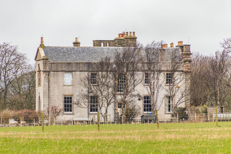
Innergellie House
Innergellie House is an 18th century mansion which incorporates part of an earlier castle.
The house sits back from the coast on the east bank of the Kilrenny Burn, formerly known as the Gellie Burn. When the first building was built on the property is not clear however a low barrel-vaulted basement is clearly much older than the later house and may date from the 15th or 16th centuries. Whether the basement was built in a rectangular or an L-plan tower originally is not known.
Around 1156 Malcolm IV confirmed a charter in which Robert of Scone, Bishop of St Andrews, granted to Matthew, archdeacon of St Andrews and Bishop of Aberdeen, various lands including Rossen, Kinnemont, Kinkellet and Innergelly.
Lands in this area of the south-east coast of Fife were held by Merleswain, Lord of Kennoway and Ardross, son of Colbán and grandson of Merleswain, around this time. His son, also Merleswain, witnessed charters by Richard the Chaplain, Bishop of St Andrews, in the third quarter of the 12th century. Towards the end of the 12th century Merleswain’s son, Waltheof, inherited Ardross, Fethkill and Kennauchy and his possessions also included Kincraig, Sandford and Elie.
Waltheof’s son, another Merleswain, was described as lord of Invergelly and died around 1250 leaving three daughters, Scolastica, Margaret of Ardross and Ela of Ardross. Judging by later references to subdivisions of the lands of Innergellie it is likely that his estates were split into three parts and distributed between his daughters as as co-heiresses.
Margaret of Ardross married Hugh de Pearsby, Sheriff of Roxburgh, and in September 1281 granted the lands of Innergelly to Dryburgh Abbey with the consent of her husband who acted as procurator. This grant was for the benefit of the souls of her and her husband, and the annual rents from the land were to go to William Fraser, Bishop of St Andrews. By 1295 she had married again, this time to Sir John de Soulis or Soules, one of the ambassadors to France who helped arrange the marriage between Alexander III and Yolande de Dreux.
Margaret’s grant to Dryburgh is confirmed by subsequent Bishops of St Andrews however the ownership of other parts of the lands of Innergellie is less clear and they appear infrequently in early records. In 1392 Christiana, sister and heiress of Galfridus de Retray, was granted one twelfth of Innergelly, which possibly represented a quarter part of one of the original thirds, along with one third of Sandford in the barony of Ardross, one third of Ballingall and of Pitgedie, and one twelfth of Balnaves in the barony of Fethkill.
Part of the lands of Innergellie seem to have come into Royal hands by the 14th century as in January 1431 James I confirmed an earlier grant by his late brother, David, Duke of Rothesay (who died in 1402), to Richard de Spaldyne of all of his lands of Lunlethyn, and of Cragon in Angus and all of his lands of Ardaray and Invergelli in Fife.
Another part seemingly had passed to the Leslies of Fethkill as in February 1440 George Leslie, later 1st Earl of Rothes, was served heir to his father, Norman de Leslie, in the eighth part of the lands of Innergilly, valued at twenty shillings yearly in the time of peace and forty shillings in the time of war, which were held from the Bishop of St Andrews. Interestingly these lands are also referred to as one half of Innergellie perhaps suggesting that this represented half of a quarter share.
James II confirmed various lands, including Inuergelly, to James Kennedy, Bishop of St Andrews, in 1452 and in 1479 and 1480 James III confirmed his father’s charter of the same lands including Invergelly to William Scheves, Archbishop of St Andrews.
At some point during the 15th century Richard de Spaldyne or Richard Spalding of Airdrie, Lamlethan and Innergellie sold his part of Airdrie to John Lummysden of Glengyrnoch, a descendant of the family of Lumsdaine of Lumsdaine.
In October 1481 John Lummisdene de Ardery received from James Rinde de Broxmouth the quarter part of the lands of Ardere, the superiority of the lands of Lathame and Redewellis, and the one-sixteenth part of the lands of Innergelly in exchange for the quarter part of the lands of Lunlethin.
In April 1526 William Lundy, as son and heir of Sir John Lundy of Lundy, was granted a precept of clare constat by John Hepburn, Prior of St Andrews, of the eighth part of the lands of Innergelly. In November of that year John Hepburn granted a a precept of clare constat in favour of Isobell Strang, daughter and co-heiress of Walter Strang of Pitcorthy, in a 32nd part of the lands of Innergellye.
Walter Lundy of Lundy received a sasine of the eight part of the town of Innergellie in a charter by James Beaton, Archbishop of St Andrews, in July 1528. In May 1531 James V granted to John Spens of Maristoun various lands which included the one-sixteenth part of the lands of Innergelly, extending to 3 merks, which John Chalmer of Drumlochy had placed in ward with Archbishop Beaton.
Isobel Strang died in 1533 or 1534 and her part of Innergellie passed to her widower, John Clephane of Carslogie. Her sister, Egidia Strang, also seems to have received a 32nd part of the lands of Innergellie from their father as in 1534 Archbishop Beaton granted to Andrew Wood both parts of a 32nd part of the town of Innergellie that had belonged to Egidia and Isobel and John Clephane. In April 1535 Archbishop Beaton granted to John Cornuelle, burgess of Crail, a twelfth part of the lands of Innergellie which had belonged to his father, William Cornuelle.
David Beaton, Archbishop of St Andrews, granted eight arable acres of Innergelle to John Lyon, 7th Lord Glamis, as heir to his grandfather, John Lyon, 4th Lord Glamis, and his great-grandfather, John Lyon, 3rd Lord Glamis, in September 1545. In 1546 or 1547 John Spens of Maristoun sold his one-sixteenth part of the lands of Innergellye, extending to 3 merklands and occupied by Alexander Howesoun, to William Arthour, a citizen of St. Andrews, and his wife, Margaret Mertyne.
By the mid-16th century the Lumsdaine family had evidently added to their Innergellie holdings as in November 1548 John Hamilton, Archbishop of St Andrews, granted a sasine in favour of Thomas Lumisden as heir to his late father, William Lummisdene, in an eighth part and a sixteenth part of the lands of Innergelly, the latter presumably the one-sixteenth part which James Rinde had exchanged with John Lumsdaine in the 15th century.
In 1560 William Barclay of Ryn was served heir to his father, Thomas Barclay, in two part of the lands of Pettarty (probably Pitcorthie or Wester Petcorthy rather than Pittarthie) and a fourth part of the lands of Innergelly, receiving a precept of clare constat by David Erskine, Commendator of Dryburgh. William and Thomas are thought to have descended from the Barclays of Kippo. Wester Pitcorthie is thought to have been used as the dower-house of Innergellie by this time. Margaret Barclay, a daughter of Barclay of Innergellie, possibly Thomas, was married to Alexander Inglis of Tarwald.
William Arthoure, son and heir of William Arthoure and Margaret Martene, resigned into the hands of Archbishop Hamilton the forty shilling lands of Innergelly which his parents had bought from John Spens and which were formerly owned by John Chalmer of Drumlochy, in favour of Chalmer’s son, William Chalmer of Drumloche in April 1570. The following month William Chalmer granted a feu charter of the forty shilling lands of Innergelly in favour of John Spens of Condy and Joanna Arnot, his wife.
Patrick Adamson, Archbishop of St Andrews, confirmed a charter of alienation by Andrew Wod of Strathwittie to William Lundy of Lundy of a 32nd part and half of a 32nd part of Innergellie in June 1582. Later that month James Lummisden of Ardrie and his wife, Euphemia Dowglass, were granted a sasine of the eighth and sixteenth parts of the lands of Innergellye which were formerly held by William Lummisden, rector of Cleisch, and alienated by him to Thomas Lummisden of Ardrie in a charter by Archbishop Adamson.
Towards the end of the 16th century James Lumsden, son of John Lumsden of Blanerne, married the heiress of the lands of Airdrie, presumably also a Lumsden, and from them descended the Lumsdens of Innergellie, Airdrie, Strathvithie and Mountquhannie.
In April 1593 James VI granted to his second cousin, Ludovic Stewart, 2nd Duke of Lennox, the episcopal revenues from the lands of the Archbishop of St Andrews which included Innergellie. Five years later the King granted to Robert Lummisden, brother of James Lummisden of Ardrie, and his wife, Isobel Cor, various lands including the eight and sixteenth parts of of the lands of Innergellie.
David Lundie of Newhall, heir to his brother, Robert Lundie of Newhall, was granted various lands in March 1603 which included “a quarter and a thirty-second part and two-thirds of another thirty-second part of the lands and vill of Innergellie, in regality of St Andrews, and two thirds of a twelfth of the lands of Innergellie”.
In March 1604 James VI granted a charter to John Erskine, 2nd Earl of Mar, of all the lands which once belonged to the monasteries of Inchmahome, Cambuskenneth and Dryburgh, including “the landis of Pettorthie and Innergellie”, uniting them all into the lordship and barony of Cardross. This was presumably the superiority of those lands. The Earl of Mar was a relation of David Erskine, Commendator of Dryburgh.
Thomas Barclay of Rynd was recognised as heir to his father, William Barclay, in Wester Petcorthy and a quarter part of the lands of Innergelly in March 1608. The house of Innergellie seems to have been situated on this quarter part. William Barclay of Innergelly is listed as a witness in Edinburgh on numerous charters in the first quarter of the 17th century, in particular in connection with the Earl of Glencairn.
In 1611 William Barclay of Innergellie gave his consent to Sir William Anstruther of Anstruther mortgaging the land, town and barony of Anstruther, with the fortalice and manor, to Patrick Black, master tailor to Henry, Prince of Wales and Duke of Rothesay.
James VI confirmed a charter by the Earl of Mar in March 1617 to his son, Henry Erskine, of the lordship and barony of Cardross which included Pitcorthie and Innergellie.
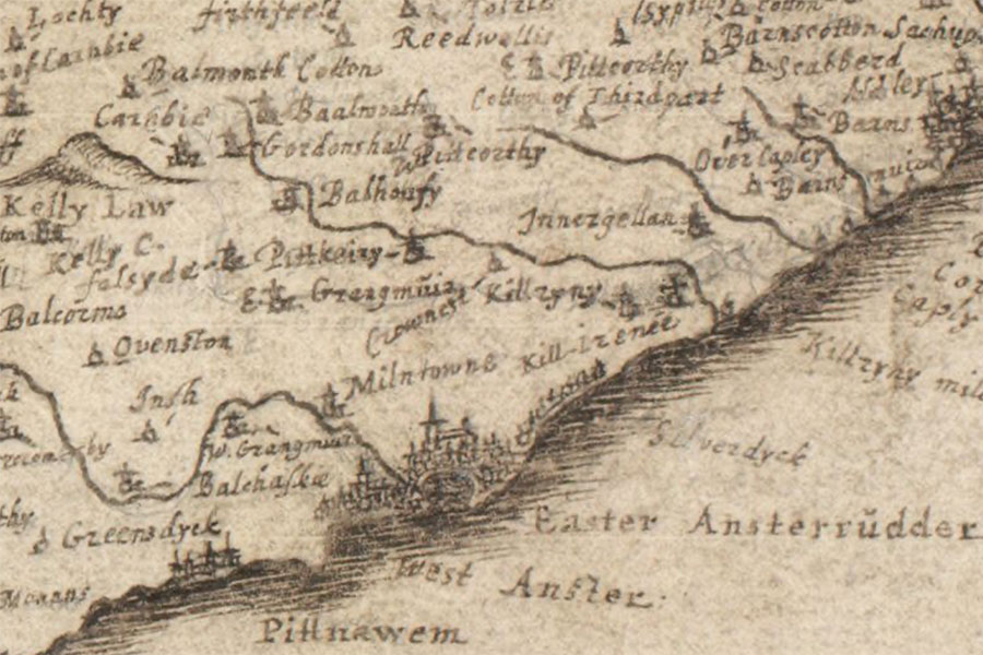
In July 1618 the Earl of Mar, by then Lord High Treasurer of Scotland, signed a contract with William Barclay of Innergellie according to the terms of which the Earl ratified in William’s favour all the infeftments of the lands of Pitcorthie Wester and the fourth part of the lands of Innergellie and the parsonage and vicarage teinds of the parish of Kilrynnie, with William undertaking to relieve the Earl of all expenses in respect of the kirk of Kilrynnie.
In February of the following year the King granted to John Scott of Scottistarvet the “decimas garbales et vicarias decimas” lands of Over Caplie alias Thridpairt, the town and lands of Nethir Caplie with the mill and mill lands, and the town and lands of Eister Pitcorthie, which the Earl of Mar had resigned with the consent of William Barclay de Innergillie.
William Barclay married Margaret Borthwick in 1619 and their marriage was commemorated by a triangular pediment carved with that date and the initials W.B. and M.B. The pediment was installed over a gate in the wall to the right of the main entrance to the house and was still visible in 1956.
By this time the house is likely to have been L-plan in form, with a wing extending south from the east end of the main block. It may have been the Barclays who built an octagonal stair tower in the re-entrant angle of the two wings, although it may date to later in the 17th century.
In 1621, for good service, Williame Berclay of Inuergellie and his wife were granted “sundry parts and portions of the town and land of Inuergellie with the pertinents (except a quarter pertaining to the Abbot of Dryburgh and also excepting a third part of a quarter of the town and lands of Inuergellie pertaining to David Beaton of Balfour)”. This seems to have consolidated a large part of the constituent parts of Innergellie.
Innergellie was erected into a free burgh of barony in favour of William Barclay of Innergellie and Margaret Borthwick by John Spottiswood, Archbishop of St Andrews, in October 1623. This was confirmed in December of that year by James VI in a charter which specified that it included, amongst other parts, the town lands and lands of Innergellie, with the one-eighth and one-sixteenth parts of Innergellie including the mills, fisheries and charcoals previously owned by James Lumsden of Airdrie, the twenty-fourth part of Innergellie with the mansion, mills, fisheries and charcoals previously owned by David Archibald of Blakhall, the third part of the twelfth part of Innergellie previously owned by William Black, burgess of Anstruther-Eister and later by his son, William Black, the forty shilling lands previously owned by William Lundie of Lundie, David Lundy of Newhall, James Geddie and Andrew Wood of Stravethie, and the 8 acres of arable land previously owned by David Betoun of Balfour.
In June 1624 James VI granted to William Barclay and his heirs the lands and barony of Rossie in Angus, comprising of the Mylntoun of Rossie, alias Eist-maynes, the lands of Stanelaw, the dominical lands of Wester-maynes of Rossie with the tower and manor, the mill of Holy-mylne, the lands of Westertoun of Rossie and the lands of Monby, which David Rossie of Rossie had placed in ward.
The King granted in July 1629 to David Carnegie of Kynnaird and his heirs various lands including the half lands of Rynd which at that time was owned by William Barclay of Innergellie.
In July 1631 Charles I granted to John Scott of Scottistarvett the lands and barony of Scottistarvett comprising of the lands and barony of Tarvett, the lands and barony of Caiplie annexed to the barony of Tarvett, the lands of Eister Pitcorthie in the parish of Kilrynnie, and various others, which were incorporated into the free barony of Scottistarvett. As part of the agreement Scott was due to pay the minister of the church of Kilrynnie £75 (and therefore the 600 merks which were due to be paid by the heir of William Barclay of Innergellie).
Around this time William Barclay, son of William Barclay and Margaret Borthwick, sold Innergellie to Sir James Lumsdaine of Airdrie, who held a commission as a Colonel in the army of Gustavus Adolphus, King of Sweden. He married Christian Rutherford of Hunthill who in 1635 was infeft in an annuity from Invergellie, presumably while her husband was serving abroad. The following year Sir James’s holdings in the parish of Kilrenny were valued at £2400.
In March 1637 David Erskine, male heir of Henry Erskine of Cardrois, was granted the lands and barony which formerly belonged to Dryburgh, including the lands of “Pitcorthie Innergellie” (“terris de Pitcorthie Innergellie”).
In December 1642 Charles I granted the Colonel a new charter of the lands of Innergellie that had been erected into a free burgh of barony in favour of William Barclay, along with the lands of Barnes, Strathvithie, Kinkell and Snawdoun, with their towers and manors, which were all incorporated into the free barony of Innergellie with the manor of Innergellie as its principal messuage.
James Gordon, 1642image courtesy of NLS
The eldest son of Colonel Lumsdaine and Christian Rutherford, also James Lumsdaine, married Margaret Bruce, daughter of the late Sir George Bruce of Carnock, in November 1643. The following month Colonel Lumsdaine granted them the lands of the barony of Barnes.
Colonel Lumsdaine returned from the Continent in 1646 and in November was given the rank of general major of the Scottish army and appointed to the Committee of War for Fife. In July 1647 his daughter, Christian, married Philip Anstruther, nephew and heir of Sir William Anstruther of Anstruther.
In 1650 an armorial panel was carved with that date and the initials S.I.L. for Sir James Lumsdaine and D.C.R. for Dame Christian Rutherford. The panel, which is now located above the front door of Innergellie, has a mantled and wreathed helm surmounted by a crest with a right hand holding a sword. Above the shield is the motto “VIRTVTE ORTA OCCIDVNT RARIVS” (“those that rise by virtue rarely fall”) while the shield itself carries the arms of Lumsdaine of Innergellie and Rutherford.
A sundial carved with the same date and initials was moved from Pitcorthie to Cairnie House near Balcarres in the 19th century.
Part of a second 17th century sundial, featuring a cylindrical shaft carved with egg and dart enrichment, is still in the garden at Innergellie.
One of Colonel Lumsdaine and Christian Rutherford’s daughters, Jean, married Thomas Ramsay, son of Gilbert Ramsay of Bamff, in October 1656. She later married David Erskine of Dun and was the mother of David Erskine, the future Lord Dun, in 1666.
Christian died at Innergellie in April 1662 and in August another of her daughters, Anna, married William Preston of Valleyfield. In January 1663 Colonel Lumsdaine married Isabel Ramsay, waiting-woman of Ord of Carnbee, a marriage which his children and friends didn’t approve of.
In June of that year the younger Sir James was appointed a justice of the peace for Fife and in the same year was included in a list of Commissioners and Committees of War for the “Presbyterie of St Andrews”. It was also in 1663 that Christian Lumsdaine’s husband, Sir Philip Anstruther of Anstruther, commissioned a new house at Anstruther and specified that it was to have a “sufficient square docote of the quantity of Sir James Lumsdaines’, of Innergellie, his docate.” The doocot at Innergellie is therefore likely to be mid-17th century in date rather than late 17th century as it is sometimes described.
In September 1665 the second son of Colonel Lumsdaine and Christian Rutherford, Robert Lumsdaine of Strathvethie, married Helen Preston, youngest daughter of the late Sir John Preston of Airdrie. The younger Sir James died at Innergellie in February 1670 and in November of that year his eldest daughter, Jean Lumsdaine, married Helen’s brother, also Sir John Preston of Airdrie.
The younger Sir James was succeeded by his eldest son, George Lumsdaine of Innergellie, who around 1680 seems to have sold Innergellie to his uncle, the aforementioned Robert Lumsdaine of Stravithie. Some time before 1697 Robert married Isabel Ellis, daughter of John Ellis of Elliston, who had inherited considerable estates from her father.
In July 1697 Isabel and some accomplices scaled the walls of Elliston, which by then belonged to John Hamilton, 1st Earl of Rutherglen, at midnight, broke in and occupied the castle, and “they brought cattle, which they turned loose, to eat whatever fodder the place afforded.” She was tried in absentia in August of the same year. The couple later separated and in December 1707 she took her husband to court to seek an allowance from him. The following year she submitted a petition requesting custody of her only son from his father, on account of his education being neglected, but the case was dismissed.
The walled garden at Innergellie is thought to date to around this period and is surrounded by rubble walls with terracing and four vaulted cellars. On the terrace are fragments of 17th century carvings representing animals.
Around 1719 Robert Lumsdaine of Lumsdaine, eldest son of George Lumsdaine of Innergellie, bought back Innergellie from his father’s uncle. Robert married Eliza, daughter of James Lumisdaine of Stravithie and granddaughter of Robert Lumsdaine of Stravithie and Helen Preston.
Robert, now styled Robert Lumsdaine of Lumsdaine, Stravithie and Innergellie, was a member of the erotic society The Most Ancient and Most Puissant order of the Beggar’s Benison and Merryland, Anstruther, which was founded in 1732 and met at Dreel Castle. In 1738 he married Sophia, eldest daughter of the late Robert Lundin of Lundin and sister of James Lundin of Lundin.
In 1740 Innergellie House was remodelled in a provincial baroque style, most notably on the north façade in ashlar which is three storeys over a sunken basement. Giant Ionic pilasters flank the outer edges of the façade which is made up of seven bays. Fluted Ionic pilasters frame the door-piece with a pedimented Ionic aedicule above containing the aforementioned armorial stone of 1650. Above this is an arched niche containing a statue of Mercury.
The projecting south-east wing is two storeys in height and is harled. It consists of five bays on its east façade with the central upper window featuring a rusticated round-headed surround.
The interior was also extensively remodelled and features a Corinthian pilastered dining room and baroque chimneypieces. A scale and platt staircase to the west of the main entrance may date from this time although it’s possible that this may be older than mid-18th century.
In 1746 a single storey Renaissance-fronted stable block was built to the north-west of the house and features a stone carved with that date and the initials RL and SL, presumably for Robert Lumsdaine and Sophia Lundin.
Robert died in 1761 and was succeeded by his son, James, who in 1769 married Christian Anstruther, daughter of Sir Philip Anstruther of Anstruther. A table sundial dated 1769 may have commemorated their marriage. It’s possible that the gate piers at the east gate and a single storey gate lodge may also date to this period.
The date of James’s death is sometimes given as 1803 however his death at Innergellie was noted in Blackwood’s Edinburgh Magazine in May 1820. He didn’t have any children and was succeeded by his brother, Robert, who must have died soon after, and unmarried without issue. Innergellie passed to their brother, Major John Lumsdaine of Lathallan, however the Major died in 1823, seemingly without issue, and Innergellie passed to a distant cousin, William Lumsdaine of Rennyhill, a neighbouring estate to the south-west. William was a great-great-grandson of William Lumisdaine of Rennyhill, the youngest son of Colonel Lumsdaine and Christian Rutherford.
The younger William died unmarried and without issue in 1830 and was succeeded by his sister, Mary Lilias, who in 1816 had married the Reverend Edwin Sandys, a descendent of Edwin Sandys, the 16th century Archbishop of York. They assumed the additional surname and arms of Lumsdaine, becoming Sandys-Lumsdaine.
Mary Lilias died in December 1864 and their son, the Reverend Francis Gordon Sandys-Lumsdaine, succeeded to Lumsdaine, Blanerne and Innergellie.
At some point in the 19th century the octagonal stair tower in the re-entrant angle of the house was given a parapeted top storey.
The Reverend Francis Sandys-Lumsdaine died in 1873 and was succeeded by his eldest son, Edwin Robert John Sandys-Lumsdaine. It seems that he rented out the house as in the late 19th century a James McLaren was resident, however the Sandys-Lumsdaines retained ownership.
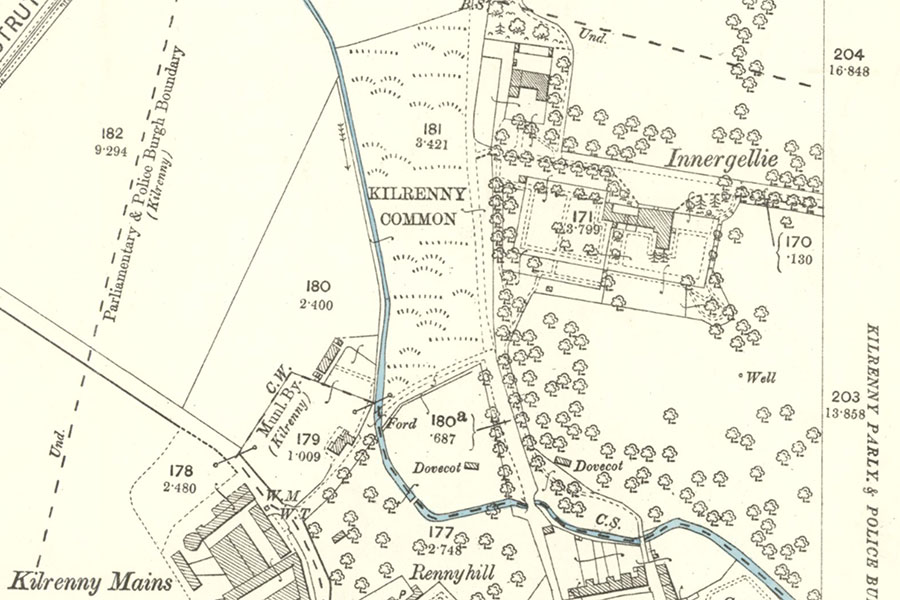
Ordnance Survey, 1895image courtesy of NLS
The Sandys-Lumsdaine family sold Innergellie House and its remaining land to Margaret MacLean, Lady Skiffington. Lady Skiffington became almost blind in her later years and when she died aged 93 in January 2004 she left her entire estate to benefit the blind of East Fife with the stipulation that public access to Innergellie South Wood should be maintained. The Lady Margaret Skiffington Trust was established in March of the same year and the trustees sold the house and policies in 2005, retaining the woodland. Innergellie House is now a private home.


Alternative names for Innergellie House
Endergaile; Endergailie; Endergaillie; Endergailly; Energellie; Ennergelly; Inner Gellie House; Inergelly; Inner-gellie; Innergalie; Innergellan; Innergally; Innergelle; Innergelley; Innergelly; Innergellye; Innergillie; Innergillie House; Innergilly; Inneryeldie; Inuergeldie; Inuergellie; Inuergelly; Inuerghellin; Invergelli; Invergellie; Invergelly