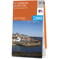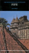
Dreel Castle
Dreel Castle was a castle belonging to the Anstruther family and although demolished stonework from it can still be seen built into the wall of a later building.
In the 12th century the church and lands of Kilrenny, of which Anstruther Easter formed a part, belonged to Dryburgh Abbey. Traditionally a Norman baron named William de Candela is said to have settled here during the reign of David I, supposedly by 1130. He is usually described as the son or grandson of the Duke of Apulia who was sent to help William the Conqueror in his conquest of England in 1066. It is perhaps more likely however that the de Candela family, while still Norman, took their name from Caundle in Dorset.
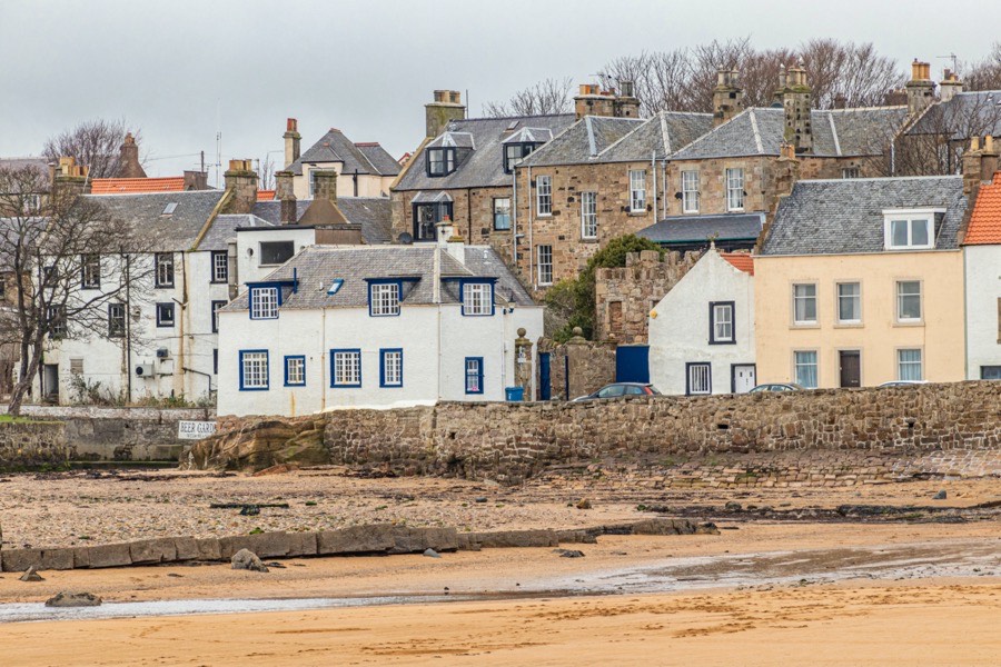
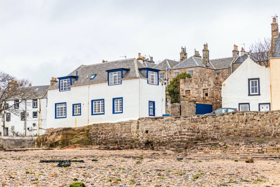
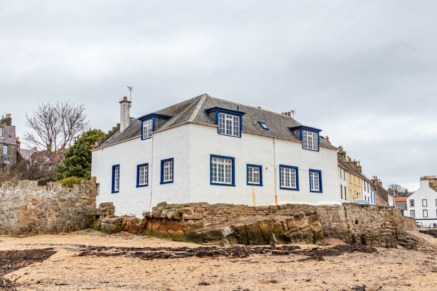
Whether or not the family built their first castle on this site or somewhere else is unclear. The site is a strategic one, occupying a rocky projection into the mouth of the Dreel Burn and overlooking what was then a natural haven with a beach where boats could be landed. The Dreel Burn separates Anstruther Easter from Anstruther Wester.
A “Mothlaw” is mentioned in a charter of 1590 to John Betoun of Balfour which may represent an early motte and castle site and the potential progenitor of Dreel Castle, however it isn’t clear exactly where it was located. The charter granted Betoun some land in Anstruther Easter and the right to draw water from a spring under the Mothlaw, which would suggest that the Mothlaw was in Anstruther Easter.
Chesterhill in Anstruther Wester, now destroyed, has also been suggested as the possible site of the Mothlaw in question. However it seems more likely that the first castle would have been to the east of the Dreel Burn rather than to the west. Betoun had already, in 1579, been granted the lands and town of Kilrenny to the north-east of Anstruther.
The first potential member of the family on record at Anstruther, although he doesn’t use the designation “de Candela”, is Gaufr’ de Einestr’, or Geoffrey of Anstruther, in the late 12th century who witnessed a grant to the Priory of May by William de Beauair of land at Airdrie. Next to appear on record is a Henrico de Ainestroth’, or Henry of Anstruther, who around 1225 granted three booths in his villa of Anstruther to the monks of Dryburgh Abbey. This grant was reconfirmed, probably in the mid-13th century, by his son, also Henry, for the good of the soul of his deceased wife, Margaret.
The younger Henry’s brother, William, also confirmed their father’s grant to Dryburgh and as William de Candela granted land in Anstruther to the monks of Balmerino Abbey, which was founded in 1229. In 1270 William, who was described as lord of Anstruther, was involved in an inquest to establish who was the rightful heir of the lands of Abercrombie.
He was dead by 1288 and succeeded by his son, Henry, who is said to have accompanied Louis IX of France on Crusade and performed fealty to Edward I of England in 1292 and 1296. Henry may have joined Robert the Bruce’s cause for a time however as there is a record of his English lands in Northumberland being restored to him in 1303 and 1304. Henry had a brother, Andrew de Anstruther, whose wife, Christian, is referred to as widow in 1336.
Around this time one of the Anstruther lairds is said to have married a daughter of Lauder of the Bass which is supposed to have later been immortalised in verse as the song of Maggie Lauder, written by Francis Sempill of Belltrees in the 17th century. Some sources suggest that Maggie Lauder was Margaret Lauder, daughter of Sir Robert Lauder of the Bass, and that William de Anstruther brought her across the Forth as his wife during the reign of Alexander I. However since Alexander died in 1124 and William de Candela isn’t supposed to have settled at Anstruther until 1130 this seems unlikely.
Robert was a popular name in the Lauder family and they can be found throughout the centuries but there are considerably less lairds of Anstruther named William. It may of course be that the William in question was a brother of the laird rather than the laird himself. In the second half of the 15th century Robert Lauder of Edrington, later Sir Robert Lauder of the Bass, had a daughter named Margaret however she is known to have married, before 1498, Kentigern Hepburn of Waughton and Luffness and in 1521 Alexander Hume of Polwarth.
I’ve lived in Fife, baith maid and wife,
These ten years and a quarter;
Gin’ ye should come to Anster fair,
Speir ye for Maggie Lauder.
The Book of Scottish Song
Glasgow, 1843
Returning to Henry, he was succeeded by his son, Richard, who may have been married to Margaret Gordon. He granted various lands in Anstruther, next to the lands belonging to Dryburgh Abbey, to his sister Cecilia’s husband, John Strang of Balcaskie in 1363. In 1366 an Andrew de Kandell was proprietor of part of Ardross, although whether he was of the same family is not clear. Three years later William de Anstruther and his wife, Mariota, were granted land in Crail which formerly belonged to Richard, son of Walter, and Mariota.
There are various members of the Anstruther on record around this time but the exact relationship between them isn’t clear. The aforementioned William may have been a brother of Richard, who may also have had a brother named Andrew who appears in a charter of 1392 and styled as Andrew de Anstruther of that Ilk in 1396.
During the reign of Robert III, in the late 14th or early 15th century, the castle at Anstruther is said to have been occupied by Sir William Anstruther and his daughter, Margaret, his son being at the court of Robert. Sir William was knick-named Fisher Willie for his custom of going out to sea with his fishermen. His daughter is said to have fallen in love with the 22 year old Patrick Home, son of Earl of Home, whose ancestor had supposedly killed Sir William’s grandfather on the Firth of Forth. The title Earl of Home wasn’t created until 1605 and the title Lord Home wasn’t created until 1473 however the progenitor of the Lords Home at this time was George de Dunbar, 10th Earl of Dunbar and March, whose fourth son was Patrick de Dunbar of Biel. Whether or not this was the Patrick of the fable is unknown.
The story goes that Sir William was in dispute with the neighbouring laird of Thirdpart, although another version of the story states that it was Sir Neil Cunningham of Barns. Neil or Nigel of Cunningham received the lands of Barns upon the resignation of Patrick of Polwarth in 1376 so it fits the timeline. The laird seems to have had intentions regarding Margaret of which Sir William did not approve leading him to insult the laird. This prompted the laird to devise a plot to kill his neighbour.
The laird invited Sir William and Margaret to his house but a wandering beggar got wind of the plan and informed Sir William who then invited the laird to Dreel instead. When he arrived Sir William hit him over the head with an axe and killed him. Sir William vowed to repay the beggar’s kindness in warning him of the danger and did so by offering his daughter’s hand in marriage, at which point the beggar is supposed to have cast off his disguise to reveal himself to be Patrick Home.
In 1445 John Anstruther of that Ilk, probably the son of Andrew, made over the lands of Morristoun or Moricetoun in Berwickshire to his son and heir-apparent, David. However David doesn’t appear to have succeeded his father, the next laird seemingly being Robert de Anstruther, possibly John’s brother. Robert married Isabel or Elizabeth Balfour and had three sons, Andrew, Robert and David. Andrew received a sasine of the lands of Moricetoun or Morestoun in 1475 suggesting his father and brother were dead, and in 1483 he received confirmation of the barony of Anstruther along with his wife, Christian Spence or Spens. He later resigned the lands of Morristoun and in 1490 they were granted to George Hume of Wedderburn.
The castle, sometimes referred to as Anstruther Castle, was by this time a large square tower of great strength built close to the edge of the Dreel Burn as it flows into the sea.
Andrew may have remarried as an Andrew married Christian, daughter of Sir James Sandilands of Calder and widow of David Hepburn of Waughton, some time after 1498. It is also possible that this Andrew was in fact Andrew’s son. An Andrew Anstruther of that Ilk is on record in 1504 and 1509 and an Andrew Anstruther fought at the Battle of Flodden in 1513. Some sources say that he was killed during the battle while others state that he survived. It’s possible that it was the son who was killed, leaving a widow, Janet Borthwick.
Robert and David, the sons of Robert and Elizabeth Balfour, went to France along with David’s sons, also David and Robert. The younger David and Robert were made officers in the Garde Écossaise of the French army around 1515. David fought at the Battle of Pavia in 1525 under the command of the Marshal of France, Robert Stewart, 4th Lord of Aubigny. Later David married Claude de Mussy and settled in Bourgogne at Bierry which was erected into the “baronnie d’Anstrude” for him, now Bierry-les-Belles-Fontaines. From David descended the Barons d’Anstrude, the last Baron d’Anstrude dying in 1928. The elder David remained in France with his sons however the elder Robert returned to Scotland. The younger Robert made a will in France in 1580 but died in Scotland in 1583.
In 1516 John was served heir to his father, Andrew, and married Margaret Douglas, daughter of Thomas Douglas of Lochleven, and the following year received a sasine of the lands of Anstruther which had been held in ward. Around 1527 he married Elizabeth Spence, daughter of Thomas Spence of Wormiston, and had four sons, Andrew, Robert, David and John. In 1528 John Anstruther of that Ilk and John Strang, younger of Balcaskie, acted as sureties for William Anstruther and thirty nine others after David Lindsay was imprisoned in the tower of Dreel.
Andrew married Margaret Abercrombie and in 1532 his father granted an inheritance of the town and lands of Anstruther to them however Andrew was killed at the Battle of Pinkie in 1547 before he could inherit. In 1548 his son, John, was served heir to his father and grandfather and received sasine of the lands of Anstruther, inheriting upon the death of the elder John in 1549.
Several cousins of John are on record around this time, including Agnes Anstruther who married John Beton of Balfour and died in 1582, Peter Anstruther who was a Captain in Flanders and died in 1589, Marjory Anstruther who married David Howison, Margaret Anstruther who married Thomas Wood, minister of Carnbee, and Catherine Anstruther who married Robert Waid.
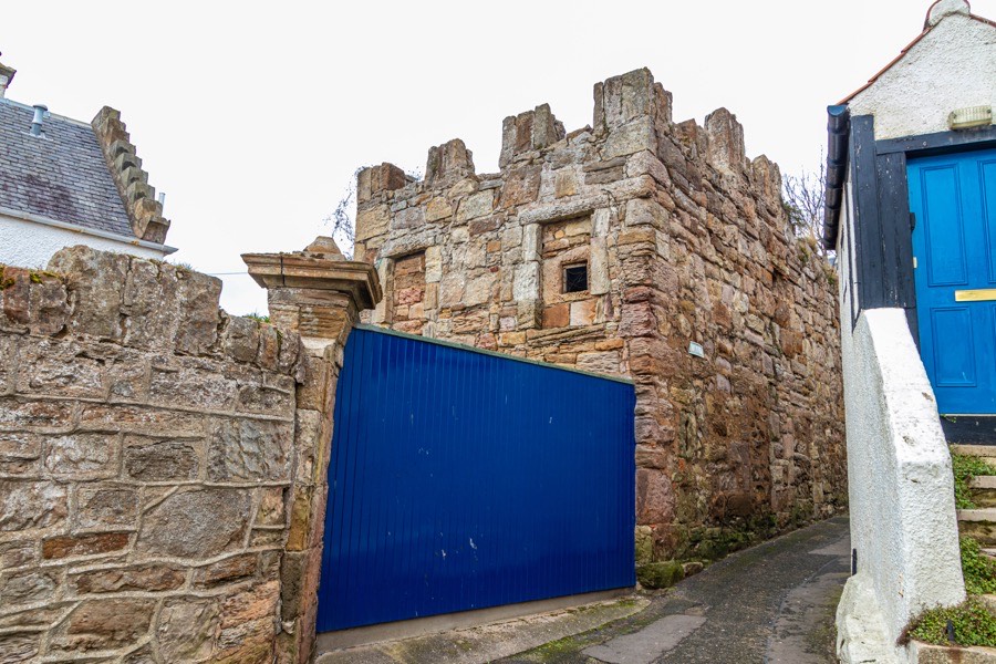
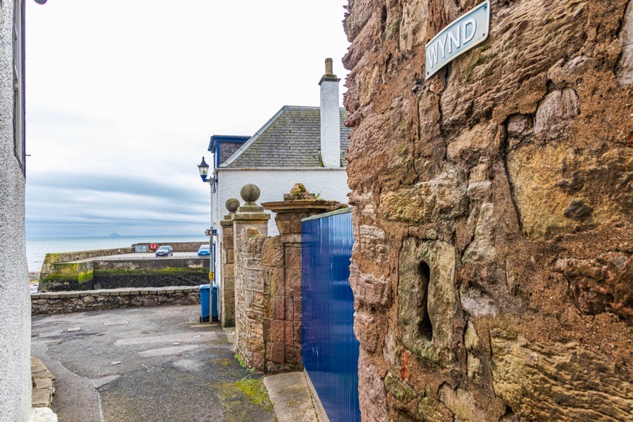
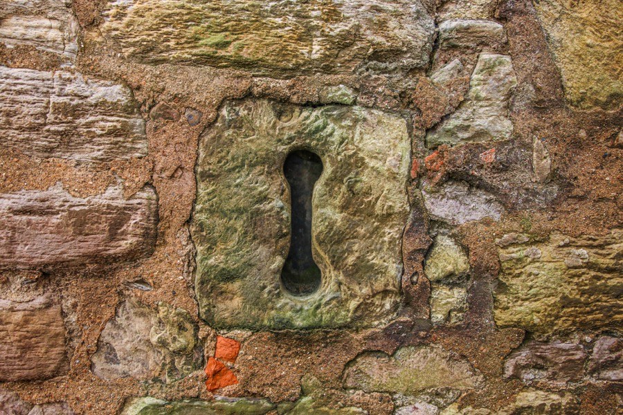
It may be during this period that the castle of Dreel was remodelled as the lower part of the wall extant today dates to the 16th century, albeit with numerous alterations. It still stands to a height of 4.3m and at its southern end is a dumbbell loophole.
In 1549 a charter by John Anstruther of that Ilk to his wife Margaret Clephane, daughter of George Clephane of Carslogie was confirmed by the infant Mary, Queen of Scots. John’s uncle, Captain Robert Anstruther, son of the elder John and Elizabeth Spence, was in 1561 the commander of the French garrison on Inchkeith in the Forth. The following year Dumbarton Castle was resigned into his hands by James Hamilton, Duke of Châtellerault who was accused of being involved in a conspiracy against the Queen.
Early in 1565 Mary, Queen of Scots, visited Anstruther on her way from St Andrews to Newark Castle and is said to have stayed at Dreel. The following year she requested safe passage and a passport for David Anstruther from Elizabeth I of England in order for him to travel to France and deal with her affairs. Following Mary’s forced abdication in 1567 Captain Anstruther overthrew the Inchkeith garrison and was rewarded with the right to salvage materials from the island.
In 1571 Anstruther Easter was created a burgh of barony by James VI for John Anstruther of Anstruther, to be inherited by his son, James, and his son’s wife, Janet or Jean Scott, daughter of Thomas Scott of Abbotshall. The charter authorised John to build a harbour and refers to the tower, fortalice and manor of Anstruther, but also to the new building in which John lives, possibly indicating either the remodelling of the castle or the construction of a new building.
John married his second wife, Margaret Learmonth, daughter of Sir James Learmonth of Dairsie and Balcomie and widow of Sir David Spence of Wormiston, in 1575. Interestingly one of the witnesses to the 1549 charter to his first wife was Patrick Learmonth of Dairsie, brother of Sir James.
In addition to his heir, James, John was also father to Andrew, John, minister of Kilrenny, who married Jean Lindsay, grand-daughter of Patrick Lindsay, 4th Lord Lindsay of the Byres and widow of John Melville of Carnbee, Grizel who married John Forret of Fingask, a daughter who married Alexander Monypenny of Kinkell, and Alison or Alisoun who married firstly Alexander Nairn, a surgeon in St Andrews, and secondly Alexander Nicolson. There may have been another daughter, Margaret, who married Archibald Herring or Heryng of Drums and Wester Gormack and in 1586 received a charter of the lands of Westir Drimmeis or Wester Drimmies from John Stewart, 5th Earl of Atholl.
In 1578 a Thomas Anstruther witnessed a charter and he may have been a cousin of the Andrew who was killed at Pinkie. Two years later the aforementioned Robert, former officer of the Garde Écossaise, returned from France however he is unlikely to be the same Robert who in 1581 acquired the barony of Ormiston. This Robert resigned Ormiston to William Ker of Cessford in 1585 and died in 1589 and may have been the same Robert as Captain Anstruther.
In 1583 Anstruther was made a free Royal burgh for the Anstruther family. John’s heir, Sir James, had become a favourite of James VI and in addition to being knighted was, in 1585, made Hereditary Carver to the King.
Sir James and Jean Scott had at least seven children, namely William, the heir, Robert who married Mary Swift, daughter of Sir Edward Swift from Yorkshire, James, Agnes or Agneta who married James Tweedie of Dryness, Jean who married firstly James Douglas, Commendator of Melrose and second son of Sir William Douglas of Lochleven, and secondly Sir John Riddell of Riddell, Grizel or Christian who married Robert Alexander, Margaret who married James Tweedie of Drumelzier and Catherine who married Robert Clephane.
In 1588 a ship from the Spanish Armada sailed into the harbour and permission was given by the laird, presumably Sir John, for 260 men to land and seek refreshment. The Spanish soldiers were described as “for the maist part young berdles men, sillie, trauchled, and houngred” and were led by Captain-General Juan Gomez de Medina, Captain Patricio, Captain de Legoretto, Captain de Luffera, Captain Mauritio and Señor Serrano. Their ship, the El Gran Grifón, would later be wrecked on Fair Isle in September of that year.
Sir James continued in employment at Court and in 1592 was made a Servitor in the chamber of the Queen’s chamber, the Queen in question being James VI’s wife, Anna of Denmark. The following year he was made a member of the Master household of the Queen’s Household.
Towards the end of the 16th century the Anstruthers were involved in an attempt to settle the Western Isles with people from Fife loyal to the Crown. The islands were considered to be a wild and untamed part of the Scottish kingdom at this time, an almost lawless fiefdom of the MacLeods of Lewis. In order to reassert the King’s control over the islands an Act of Parliament was passed in 1597 requiring chiefs to present their titles to the Lords of the Exchequer on Whitsunday in 1598 and to provide security for any rents owed to the Crown. When the chiefs of Lewis, Harris, Dunvegan and Glenelg failed to produce their titles their estates were declared forfeited.
Lewis was granted to a company of adventurers from Fife which included Sir James Anstruther, younger, of that Ilk, Sir Patrick Leslie, Commendator of Lindores, Sir William Stewart, Commendator of Pittenweem, James Learmonth, younger, of Balcomie and James Spence of Wormiston, led by Ludovic Stewart, 2nd Duke of Lennox, who was later involved in the Plantation of Ulster and the colonisation of New England. They set out for Lewis in October 1599 on an ill-fated expedition to colonise the island hampered by the weather, disease and conflict with the MacLeods.
Sir James Anstruther sold the mill of Anstruther to David Alexander, a burgess of Edinburgh in 1598. In 1601 he was a member of the Master household of the King’s Household and in the same year his eldest son, William, a gentleman of the bedchamber to James VI, married Euphemia Wemyss, daughter of Sir Andrew Wemyss of Myrecairnie. Two years later William accompanied the King to London and was made a Knight of the Order of Bath.
In 1606 Sir James predeceased his father, John, and so didn’t inherit, and when his father died in 1610 he was succeeded by William, the eldest son of Sir James. In 1611 Sir William, with the consent of his brother, Robert, and William Barclay of Innergellie, mortgaged the land, town and barony of Anstruther, with the fortalice and manor, to Patrick Black, master tailor to Henry, Prince of Wales and Duke of Rothesay.
Sir William’s brother and Sir James’ second son, Sir Robert, was a diplomat for James VI, and later Charles I, and in 1613 he was entrusted to deliver private correspondence between Queen Anne and her brother, Christian IV, King of Denmark and Norway. By 1620 he was ambassador to Christian and also to Ferdinand II, Holy Roman Emperor, and in 1626 negotiated a resolution between the two of them. Sir Robert was a Privy Councillor and bought some of the earliest pictures in the Royal Collection while in Germany.
In 1614 the mortgage of Anstruther was reconfirmed to Patrick Black and his son, Charles, however in 1619 Patrick renounced the lands of Anstruther and they returned to Sir William. He granted the two parts of the lands of Wester Pitcorthie, anciently owned by Dryburgh Abbey, to Sir John Scot of Scotstarvit, a member of the Privy Council, in 1624. In 1628 he granted the lands, town and barony of Anstruther to James Scott and in 1629 Sir James Scott of Abbotshall, Sir William’s maternal uncle, and John Wood were both infeft of the barony of Anstruther.
Sir William received a charter of the mill of Pittenweem in 1631 which William and John Moncreiff of Balcaskie had resigned and in 1636 John Wood disposed of the barony of Anstruther in favour of the heirs of his body and ultimately the barony returned to the Anstruthers. In 1637 Sir William bought Melville’s Manse at the top of Anstruther from Ephraim, eldest son of the Reverend James Melville, and used it as his manor house, it presumably being deemed more fitting for a man of his position than the old tower of Dreel.
Sir Robert died in 1644 and was buried in Westminster Abbey. He was succeeded in his English estates by his second son, also Robert. Sir William died in 1649, soon after Charles I was executed. Some sources state that he died without issue while others state that he had a daughter, Anne, who married Sir John Riddell of Riddell, however she may have been confused with Sir William’s sister, Jean. In either case he was succeeded by his nephew, Philip, Sir Robert’s third son, who had married Christian, daughter of Major General Lumsdaine of Innergellie, in 1647 and was knighted in 1650.
They had seven sons, two of whom were made baronets of Nova Scotia, and three daughters, namely Sir William, the eldest son and heir, Sir James of Airdrie who married Katharine, daughter of John Skene of Hallyards, Sir Robert of Balcaskie, Sir Philip of Anstrutherfield, married Elizabeth, daughter and co-heiress of James Hamilton of Mountainhall, Sir Alexander who married Jean, grand-daughter of General David Leslie of Newark, David, John, Sophia, Anna and Mary.
Sir Philip was a Royalist and following Charles II’s Scottish coronation at Scone in January 1651 the King travelled to Fife and on the 14th of February “he came alonge the coast by Levin, Largo, Ellie, and lodged att the Laird of Ensters house all night”. During dinner the King is reported to have exclaimed “Eh, what a fine supper I’ve gotten in a craw’s nest!” which supposedly annoyed Sir Philip so much that he vowed to build himself a new, grander home. The location of this dinner has always been assumed to have been Dreel Castle, however it is also possible that it was in fact Melville’s Manse.
Later that year on the approach of Cromwell’s army the burgesses of Anstruther stored valuables and documents in Dreel Castle. The burgh was sacked, the castle taken and the valuables and documents were transported to London however the ship sank on its way with all contents lost. In September 1651 Sir Philip was taken prisoner following the Battle of Worcester where the Royalist cavalry was commanded by General Leslie. The family’s estates were confiscated however upon the restoration of Charles II in 1660 they were returned.
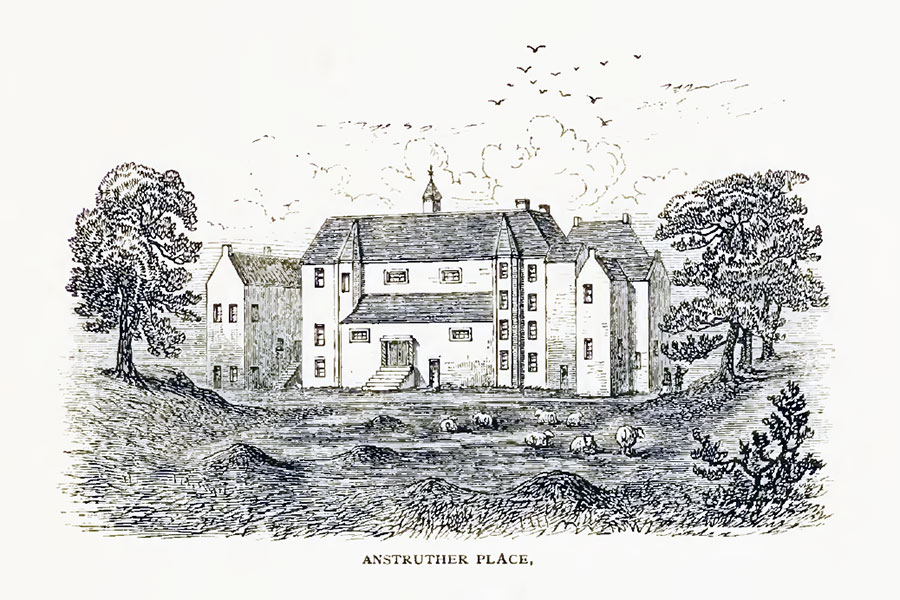
In 1663 Sir Philip signed a contract with Alexander Nesbit, deacon of the masons in Edinburgh, for a new mansion in Anstruther which became known as Anstruther Place. The contract stated that it:
“shall be 76 feet by 24 feet within the walls, and of four storey, and the walls four feet thick. The hall and dining-room were on the second storey, and the windows in the former were to be “as large and complete as those in the hall of Kellie.” There was a large rustic entry-gate on the west side “conform to the principal gate of Belcarres,” and “sufficient square docote of the quantity of Sir James Lumsdaines’, of Innergellie, his docate.” The price, including a stable and a bake and a brew house, was fixed at 2200 merks, and 16 bolls of oatmeal, besides the joiner work, for which was paid 200 merks, 4 bolls oatmeal, 4 bolls pease, and 2 bolls bere : and the iron work, the payment of which was £200, and 2 bolls of meal.”
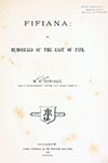
Fifiana, or, Memorials of the East of Fife
Matthew Forster Conolly, Glasgow, 1869
Matthew Forster Conolly, Glasgow, 1869
Sir Philip received a ratification in 1669 which mentions the town, barony, tower, fortalice and manor place. When he moved in to Anstruther Place Melville’s Manse was used as a dower house until 1713, and Dreel Castle seems to have been left to fall into ruin. It isn’t clear exactly where Anstruther Place was located however it seems unlikely that it was built on the site of Dreel Castle as it was described as “a goodly house overlooking the town” and the ruins of Dreel were still standing into the 18th century. This would suggest an elevated position further to the north and Historic Environment Scotland gives a grid reference of NO 5650 0365 near the junction between St Andrews Road and Crail Road. Anstruther Place was demolished in 1811 when a new turnpike road was built however Clydesdale Bank House was later built either close to or on the site of it.
Around 1690 Sir Philip’s eldest son, Sir William, bought the lands of Ardross, together with those of Elie, Bruntshiels, Muircambus and Carmurie, and in 1694 he was granted a charter by Queen Anne “of the baronies of Anstruther and Ardross, with many other lands”. He commissioned the grand mansion of Elie House to be built and the Anstruthers moved there, leaving Anstruther Place to be tenanted by old servants of the family.
In 1704 a Crown Charter, ratified by Parliament in 1705, erected Sir William Anstruther’s lands into the Barony of Anstruther and conferred upon him the hereditary titles of Master Carver and Master of the Household which were held by his ancestors.
The ruins of Dreel Castle were apparently still partially habitable in 1732 when it served as the meeting place for a newly-formed erotic society named The Most Ancient and Most Puissant order of the Beggar’s Benison and Merryland, Anstruther. The society, which met twice a year on Candlemas and St Andrew’s Day, took its name from a story about James V who was said to have been carried across the Dreel Burn to the Castle of Dreel by a young beggar woman who said “May your purse ne’er be toom and your horn aye in bloom”.
The last remains of the castle, possibly the basement vaults, seem to have been removed in the early 19th century and by the end of that century the site was occupied by a cooperage and “an antiquated tenement called Wightman’s house”. Today only the section of 16th century walling and gunloop remain on Wightman’s Wynd close to its junction with Castle Street. Dreel Lodge, a converted 18th and 19th century L-plan stable block, stands on what would have been the western and southern edges of the castle’s courtyard.
HMS Dreel Castle, an Auxiliary Patrol Base at Falmouth, Cornwall, during the First World War was named after the castle.


Alternative names for Dreel Castle
Ainestroth; Ainestrother; Anestruthire; Anster; Ansteruthyir; Anstrother; Anstrudir; Anstruther Castle; Anstruther Place; Anstruthir; Anstruthire; Anystrother; Aynestrother; Aynestrothere; Aynestrothir; Aynstrother; Aynstrothir; Aynstruther; Castle of Dreel; Einestr; Einestrothir; Einstruther; Eynestrother; Eynstrother; House of Anstruther; Kinstrother; Kynanstruther; Tower of Dreel