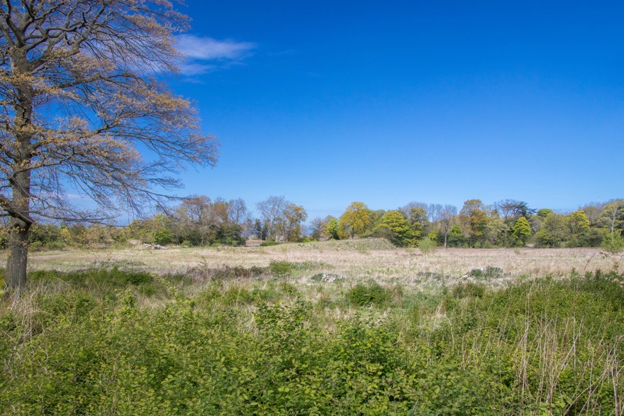

Edmonstone House is said to have dated back to the 13th century, but was demolished in the 1950s.
The lands of Edmonstone are thought to have been named after Edmund or Edmond, said to be a descendant of someone of the same name who was a Saxon member of Queen Margaret’s retinue who arrived in Scotland in 1068, and who may have been a son of Count Egmont of Flanders.
The first record of the name comes from a charter thought to date to around 1210 which mentions a Henricus de Edmonston, or Henry Edmonstone, who intriguingly is described as “son of E.” which is thought to signify the original Edmund from whom the family descend. Henry is mentioned again in several charters throughout the 13th century and it was in that century that a castle is said to have first been built at Edmonstone, possibly by Henry or Edmund.
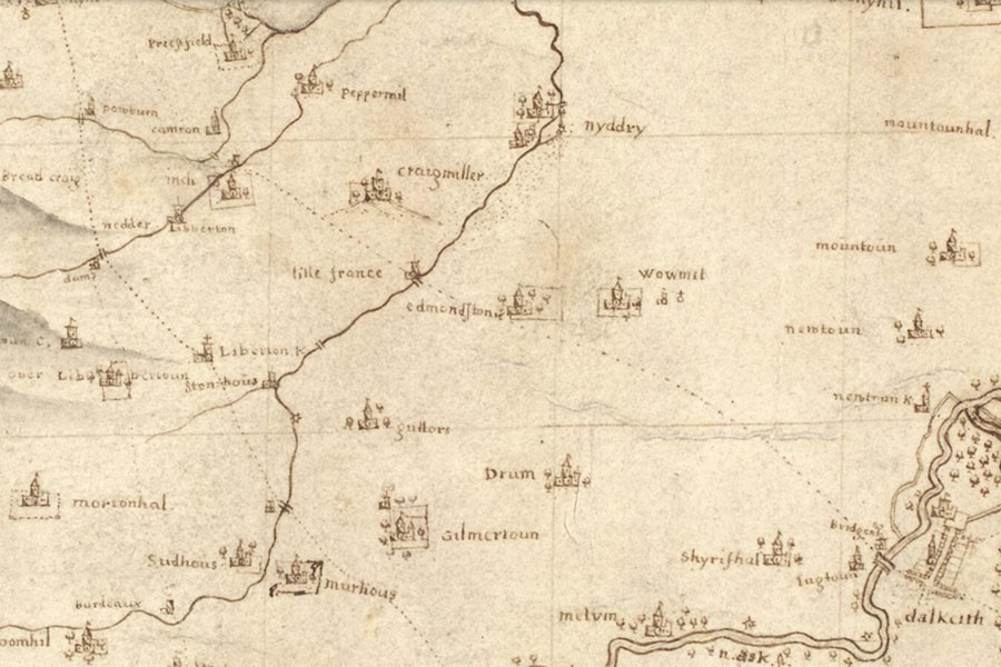
The position is an elevated one occupying the north-east end of Edmonstone Ridge and commanding the surrounding land, which to the north west dips down to the Niddrie Burn at Little France before rising again to Craigmillar Castle. What form the castle took is unknown however 19th century reports refer to evidence of a moat and courtyard wall having been discovered, and on Blaeu’s map of 1654 it is depicted as similar in style to Craigmillar.
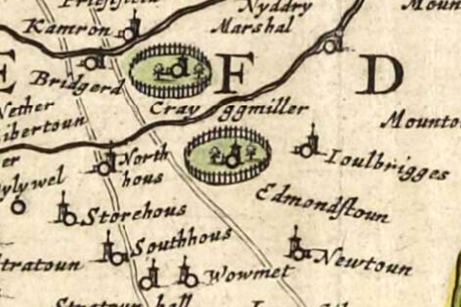
Joan Blaeu, Amsterdam, 1654image courtesy of NLS
A later Henricus is recorded in 1359 as having died and been succeeded by his son Johannes de Edmundiston. In 1352 a charter of the office of coroner for Lothian was given to John of Edmonstone. John Edmonstone evidently acted on diplomatic matters for David II, travelling to England on the King’s behalf at various times in the 14th century, and was given a grant of the thanage of Boyne in Banffshire in 1369. He seems to have continued this work for Robert II following the death of David II in 1371, and his son, also John Edmonstone, married Robert II’s daughter Isabel or Isabella.
At some point during the 16th century, in the reign of James V, a feud broke out between the Edmonstone family and their neighbours the Wauchopes of Niddrie. It turned into a hereditary long-running affair which continued for a century.
Edmonstone House remained the main residence of the Edmonstone family until 1626 when Andrew Edmonstone sold it to James Rait (sometimes written as Raith), who later had this confirmed in a charter of 1630. In 1633 the Records of the Parliaments of Scotland recorded an act in favour of “James Raith, advocate, and Eliza Fouller, his spouse….of all and sundry the town and lands of Edmonstone, called the Mains of Edmonstone, with manor place, mansion houses, buildings, yards, orchards, meadows, dovecot, cuningars and all their pertinents”.
Rait’s eldest daughter, variously written as Ann, Anne or Anna, married Sir John Wauchope, a senator of the College of Justice and second son of Sir John Wauchope of Niddrie, possibly in 1664, and Edmonstone passed into the Wauchope family. The younger Sir John would later be created Lord Edmonstone in 1672 when appointed as a Lord of Session.
John Adair, Edinburgh, 1682image courtesy of NLS
To the east of the estate (at NT 3053 6987), just off what is now Edmonstone Road, was Woolmet parish church (united with Newton parish some time after 1232. In 1641 the church was given to the laird of Edmonstone for use as a private chapel, and was later used exclusively for Edmonstone family burials. After falling into disrepair, in 1834 it was converted into a mausoleum by Mr Wauchope.
To the north-east of the house (at NT 3015 7001) stood a dovecot of an interesting construction. Described by the RCAHMS as having been adapted from the ingle of a 16th or 17th century house, the chimney of which was topped off with a tall, slim pyramidal finial. It was still a substantial ruin in 1975 but seems to have been demolished some time before 2004.
In the 18th century the Wauchope family built a new mansion on the site of the old castle and carried out considerable work on the estate. The large walled garden to the south-west of the house is thought to have been established by this time, although its origins may be older. The gate piers and entrance at the south of the estate are late 18th century in date. A tree-lined avenue running from the south gate to the house is shown on John Laurie’s map of 1766.
When drains were dug on the estate during the 19th century evidence of a moat was uncovered, “its inner wall exhibiting excellent masonry”.
An elaborately-carved sundial once stood in front of Edmonstone House, and while the date of its creation is unknown it is said to have been similar in style to an example in Cramond thought to date to the first half of the 18th century. The current whereabouts of the sundial is not known.
Edmonstone Colliery was established to the north of the estate in the early 18th century, taking advantage of seams of coal in the area.
Around 1800 the house was damaged by fire and it is said to have been rebuilt and redesigned by an architect named “Mr. Adam”, although presumably not Robert Adam since he died in 1792. During the restoration while workmen were removing a window in what was, in 1892, the library they discovered an old skeleton within the walls with a sword nearby. The skeleton was apparently wearing leather shoes which appeared well preserved, but upon exposure to the air they crumbled into dust. It has been supposed that the skeleton may belong to the victim of the feud with the Wauchopes of Niddrie.
Around 1821 the architect Archibald Elliot was responsible for building stables around a courtyard to the north of the mansion. In 1822 part of an old courtyard wall which was still standing was removed to allow new kitchens to be built on the east side of the house. This wall is also said to have enclosed an old garden, suggesting a garden closer to the house rather than referring to the walled garden.
A few metres to the east of the stables is an icehouse, partly sunk into the ground. The floor of it is cup-shaped and the ceiling domed, making the interior spherical in shape.
Following another fire William Burn was commissioned to work on the house around 1830, and was responsible for remodelling the drawing room. By this time Edmonstone House stood at the centre of a well-developed estate as shown in John Thomson’s “Atlas of Scotland”, published in 1832 but based on John Knox’s “Map of the shire of Edinburgh”, published in 1816.
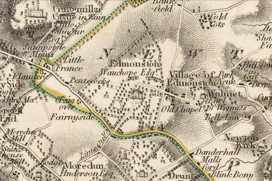
John Thomson, Edinburgh, 1832image courtesy of NLS
During the building of Edmonstone Biomedical Centre in 2005 19th century ha-ha walls were uncovered to the north-west of the house, with two field boundary meeting the ha-ha perpendicularly thought to pre-date the ha-ha. The later Ordnance Survey six inches to one mile map shows the features of the estate in greater detail.
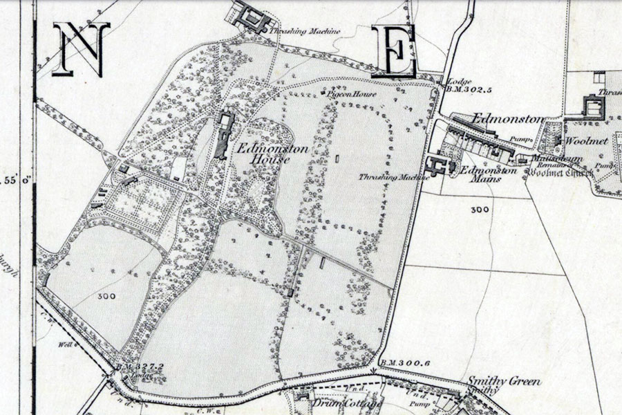
Ordnance Survey, 1854image courtesy of NLS
In 1862 Edmonstone House became the property of John Don Wauchope. Back in the late 17th century an Anne Wauchope had married a Patrick Don who took his wife’s surname. The Dons were Baronets of Newton (near Kelso) and following the death of the 7th Baronet Don of Newton without a male heir Anne and Patrick’s great-great-grandson John Wauchope was named heir, adding Don to his name.
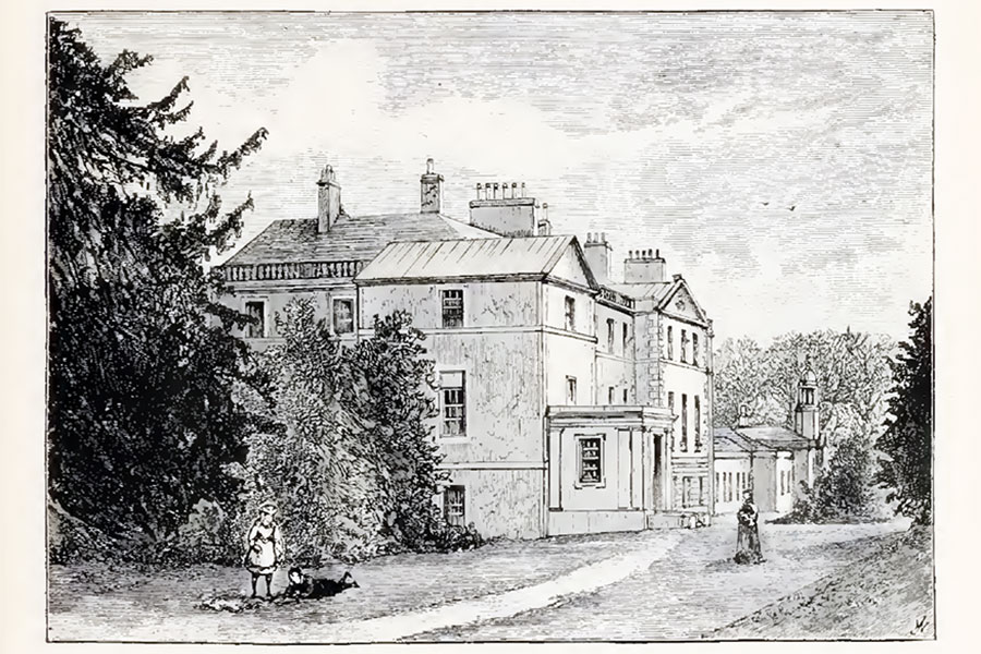
Cassell’s Old and New Edinburgh, 1881
By 1953 Edmonstone House was no longer inhabited, and according to aerial photographs from 1961 it was by then a roofless shell. The house was demolished soon after but the walled garden continued to be used for a time as a market garden.
In April 2004 EDI, a development company owned by the City of Edinburgh Council, bought 150 acres of land from the Don-Wauchope family in a deal worth £20 million. Plans for a grand public recreational space with woodland footpaths and cycle paths were unveiled but didn’t come to fruition.
Later that year in September the developers Boskabelle Ltd submitted plans to build an 80 bed private hospital, with the remaining architecture preserved and the estate opened up for public use. Allan Murray Architects were appointed to design the hospital and outline planning consent was granted in September 2006.
In August and September 2006 an archaeological investigation was carried out with eight trial trenches being dug to identify the location of the mansion. Four of the trenches revealed substantial stone walls which enabled the extent of the surviving ground plan to be established while the remaining trenches to the south and east of the house contained nothing of archeological significance.
The plans were extended in 2008 with the addition of a care home within the walled garden and the creation of a “care village” consisting of 170 homes next to the hospital. In March of that year a more extensive archaeological dig was carried out with some 96 trenches dug to evaluate areas on the estate designated for proposed tree planting, along with a photographic survey and recording programme of surviving architectural and landscape features. To the east of the remaining stable block the remains of a ha-ha were discovered. In a poor state of repair, three former gateways and two possible abandoned wells on the eastern side were identified.
At the southern end of the estate another ha-ha was identified, the foundations of which were discovered to continue below an existing entranceway suggesting that it post-dated the ha-ha. In the south-east quadrant of the estate a a stone-built culvert, a series of wells and a sunken wall running north to south were also revealed.
To the west of the walled garden the stone foundations of a possible boiler house were uncovered, which would have provided under-soil heating through a network of pipes and wall cavities – known as a “hot wall” system – to allow the cultivation of exotic plants.
The investigation didn’t reveal any medieval activity, although a possible Roman road was discovered on the east side of the estate and evidence of later use of the estate was found in the form of rig and furrow field systems and, on the eastern side of the estate, numerous features, structures and deposits associated with mining.
In May 2011 the Isle of Man-based developers Baywater (IOM) Ltd sought planning permission for 200 homes, a hotel and a supermarket. In May the following year Sheratan Ltd, another Isle of Man-based developed with the same address as Baywater, applied for permission to build 114 houses on the estate, although permission was refused. December 2012 saw an application by Baywater (IOM) Ltd for planning permission to create a cemetery within the eastern two-thirds of the estate, leaving the western third available for housing.
In August 2013 the Edmonstone Estate was included in the City of Edinburgh Council’s Revised Craigmillar Urban Design Framework stressing the importance of preserving it as an important green space within the city’s Green Belt. Despite this applications have been made by housing developers to have Edmonstone removed from the designated Green Belt to allow new homes to be built within the estate’s boundaries.
Sheratan Ltd submitted amendments to their May 2012 planning application in February 2014, and this time they were successful in their application. The company Edmonstone Homes Ltd, with the same address in the Isle of Man as Sheratan and Baywater, subsequently marketed homes as “Belle Vue at Edmonstone Estate”, a beautiful development of 3, 4 and 5 bedroom family homes”. A rather sad end for a historic estate.
Alternative names for Edmonstone
Edmiston; Edmondstoun; Edmonston House; Edmonstone House; Edmondstone; Edmonston House; Edmonstoun'; Edmonstown; Edmundistun; Edmundston; House of Edmonstone


