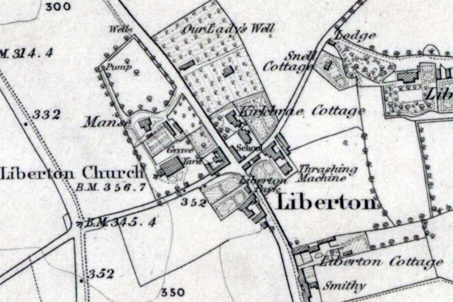

Ordnance Survey, 1855
The Castle of Malbet stood on or near this site, but not much is known about it.
It is thought to have been the principle residence of Malbet (variously referred to as Mael Bethad, Mael-beatha, Malbeth, Macbeth, Macbeth Bere or Macbether) who was in possession of the barony of Liberton in the time of David I, and may have taken the form of a tall peel tower. The house is mentioned in a document thought to date from 1185 to 1189 in which William I grants the land beside the house which belonged to Malbeth’s to Richard de Melville. An earlier document from 1166 to 1170 granted Malbeth’s land in Liberton and Leadburn to Geoffrey de Melville and his son Gregory, Richard’s grandfather and father respectively.
Both documents seem to refer to Malbeth in the past tense, suggesting that he had died by that time. However he is listed as a witness in a document dating to some time between 1124 and 1139, and he may have been alive as late as 1141 to 1150 when he witnessed David I’s grant of land at Ruchale to Newbattle Abbey. Malbeth’s son Symon was sheriff of Traquair in 1184.
The RCAHMS place the site of this castle just to the west of Guthrie Court care home (formerly Dr. Guthrie’s Original Industrial School for Boys) however this may be a mistake. A 19th century book about Liberton refers to the castle as probably having “stood on or near the court of the present school” and that an “old house, now demolished, stood on this site as late as 1840.” The RCAHMS seems to have taken this to mean the Industrial School however I believe it was actually the school which stood to the east of Liberton Kirk across Kirk Brae, now occupied by Liberton Nursery School.
In their notes they state that the school is at NT 2752 6947 on the Ordnance Survey six inch to one mile map of 1855, however those coordinates provide a location on the footpath of Kirkgate and refer neither to the village school or the Industrial School. The Industrial School didn’t open until 1887 and so isn’t marked on the 1855 map but the village school is.
For now I have placed the site of the castle at NT 276 695, where the nursery now stands.
When the old house that stood on the site of the castle was demolished stones from it, including window sills and lintels, were used to build buttresses “against a wall on the Penicuik Road at the foot of Liberton Brae” but by the late 19th century they were “covered up”, presumably with render. A sundial which had been installed on the third floor of the property went to a neighbour. The sundial was carved with the date 1676, the inscription “God’s providence is my inheritance” and the initials R.H.J.G or R.H.I.C.
Alternative names for Castle Of Malbet
Malbet Tower; Tower Of Malbet
Where is Castle Of Malbet?
Castle Of Malbet is in the parish of Edinburgh and the county of Midlothian.
Grid reference: NT 276 695
Lat / long: 55.913678, -3.159691


