Cargill
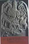
This Class I symbol stone is located within a rockery in the gardens of Balholmie House having been moved from where it was discovered.
The stone was first recorded by A Fergusson, schoolmaster of Cargill, in the 19th century when it was to be found standing upright in a dry stane dyke that enclosed a plantation around 600m north-west of West Whitefield Farm. It was moved to Balholmie some time before 1969.
Around 0.91m in height and 0.66m wide, the slab of whinstone is up to 0.25m in thickness. One face is incised with a rectangle symbol within which are a pair of opposing “comma” symbols above a central motif and pair of vertical lines. To the left of the rectangle is a second simpler rectangle surmounting a long shaft.


Alternative names for Cargill
Balholmie House; Balhomie House
Where is Cargill?
Cargill is in the parish of Cargill and the county of Perthshire.
Grid reference: NO 16050 34550
Lat / long: 56.495518, -3.365157
Directions to Cargill
Enter a starting point

Weather at Cargill
max 13°C / min 12°C
1029mb
93%
6%
03:44 20:53
Clear sky
Weather observed at Saint Martins at 04:44