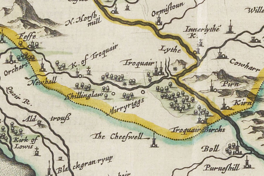
Joan Blaeu, Amsterdam, 1654map image courtesy of NLS
There was apparently a peel tower at Innerleithen in the 16th century although its exact location is now lost.
It may be the tower marked as Lythe on Blaeu’s mid-17th century map which is shown just west of the confluence between the Leithen Water and the River Tweed.
I have placed the location at the Toll House pending further research.
Innerleithen was one of a series of towers along the Tweed valley, each of which was visible from the next. Elibank would signal to Holylee, Holylee to Scrogbank, Scrogbank to Caberston, Caberston to Bold, Bold to Purvishill and then on to a continuing chain from Innerleithen to the north-west.
The signal would then pass along to Traquair, Grieston, Ormiston, Cardrona, Nether Horsburgh, Horsbrugh, Haystoun, Peebles and on to Neidpath. From Neidpath it would continue to Caverhill, Barns, Lyne, Easter Happrew, Easter Dawyck, Hillhouse, West Dawyck, Dreva and on to Tinnis.


Alternative names for Lythe
Innerleithan; Innerleithen
Where is Lythe?
Lythe is in the parish of Innerleithen and the county of Peeblesshire.
Grid reference: NT 33316 36065
Lat / long: 55.613591, -3.060209