Craighall
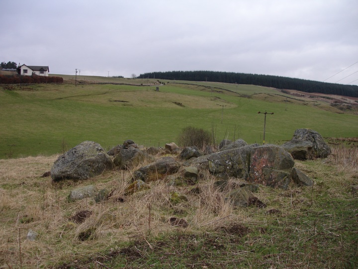
This is a very disrupted site, obviously affected by its proximity to the field. Nonetheless it is still an interesting site, with four large stones lying on a mound 9.0m in diameter by 0.2m high. The stones, all rough boulders, are unlikely ever to have stood erect. The one at the N corner is the smallest, with the other three being of similar size, although the one at the S corner has split in two. Field clearance has been added to the circle.


Alternative names for Craighall
Courthill; Glenballoch
Where is Craighall?
Craighall is in the parish of Rattray and the county of Perthshire.
Grid reference: NO 1842 4807
Lat / long: 56.61687172, -3.329799442
OS Map for Craighall
Directions to Craighall
Enter a starting point
Get directions
Weather at Craighall
8°C
max 10°C / min 8°C
max 10°C / min 8°C
5km/h ESE
1006mb
63%
100%
04:37 19:44
1006mb
63%
100%
04:37 19:44
Light rain
Weather observed at Blairgowrie at 16:12

References (books)

The Stone Circles of Britain, Ireland and Brittany
Aubrey Burl
London and New Haven, 2000
London and New Haven, 2000
References (websites)
Ancient sites near Craighall
Castles near Craighall
Pictish stones near Craighall
Pictish sites near Craighall

Accommodation near Craighall
Blairgowrie Holiday Park
2.0km away
The Royal Hotel, Blairgowrie
2.7km away
Angus Hotel
2.8km away
Altamount Country House Hotel
3.4km away
Bridge of Cally Hotel
5.7km away
Corriefodly Holiday Park
5.9km away
Alyth Hotel
6.1km away
Old Stables Bed and Breakfast / Self-Catering
6.2km away
Lands of Loyal Hotel
6.4km away
Meikleour Hotel
9.6km away
Accommodation search
Cafés, restaurants & bars near Craighall
Altamount Country House Hotel
3.4km away
Alyth Hotel
6.1km away
Lochside Lodge & Roundhouse Restaurant
11.8km away
Atholl Arms Hotel, Dunkeld
16.6km away
Murrayshall House Hotel
22.1km away
Premier Inn Dundee West
23.3km away
Holiday Inn Express Perth
23.7km away
Premier Inn Dundee North
24.0km away
Kinnettles Castle
24.2km away
Huntingtower Hotel
24.9km away


