Invereen

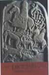
This symbol stone was discovered in a field near Invereen on the floodplain of the River Findhorn in 1932, when it was ploughed up by a farmer.
It measures around 1.0m tall by 08.m wide, and is 0.15m thick. Carved on one side are a crescent and V-rod symbol (with two further smaller crescents within the main one) and below this is a double disc and Z-rod symbol.
At the top-left corner of the stone is a third carving, apparently damaged by the plough, which may represent a penannular brooch.
The stone is now in the National Museum of Scotland in Edinburgh.
Where is Invereen?
Invereen is in the parish of Moy and Dalarossie and the county of Inverness-shire.
Grid reference: NH 7968 3108
Lat / long: 57.354313, -4.001361
OS Map for Invereen
Weather at Invereen
2°C
max 2°C / min -1°C
max 2°C / min -1°C
10km/h S
993mb
95%
100%
08:45 16:04
993mb
95%
100%
08:45 16:04
Overcast clouds
Weather observed at Inverness at 08:42
References (books)
References (websites)
Pictish stones near Invereen
Pictish sites near Invereen
Pictish placenames near Invereen
Ancient sites near Invereen
Castles near Invereen
Accommodation near Invereen
Glenan Lodge Guest House
1.6km away
Slochd Mhor Lodge
8.9km away
Tigh na Sgiath Country House Hotel
11.4km away
Dalrachney Lodge Hotel
13.7km away
The Coach House at Dalrachney Lodge
13.7km away
Carrbridge Hotel
13.7km away
Macdonald Lochanhully Woodland Club
14.2km away
Fairwinds Hotel
14.7km away
New Drumossie Hotel
14.9km away
The Pines Country House
15.3km away
Cafés, restaurants & bars near Invereen
Dalrachney Lodge Hotel
13.7km away
Macdonald Lochanhully Woodland Club
14.2km away
New Drumossie Hotel
14.9km away
Culloden House Hotel
17.1km away
Premier Inn Inverness East
17.3km away
Best Western Lochardil House Hotel
18.0km away
Kingsmills Hotel
18.1km away
Crown Court Town House Hotel
18.6km away
Heathmount Hotel
18.7km away
Rocpool Reserve Hotel & Chez Roux
18.7km away


