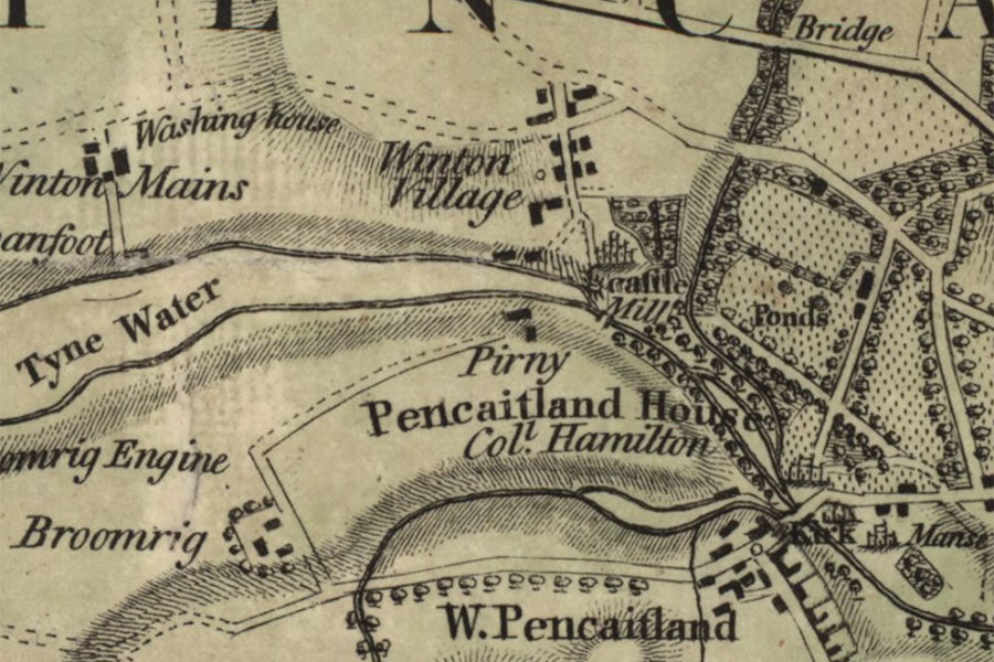

William Forrest, Edinburgh, 1802map image courtesy of NLS
Pirn Castle used to stand close to the former hamlet of Pirnie, to the north-west of Wester Pencaitland, although nothing now remains of either of them.
Very little seems to be known about the castle which once stood on the south bank of the Tyne Water to the west-south-west of Winton Castle. It isn’t marked on 17th century maps of the area which only show Winton Castle, the settlement of Pencaitland and Ormiston Castle in the vicinity.
In late 17th century hearth tax records for East Lothian, John Howie is recorded as having one hearth at Pirn Castle. This would suggest that either the castle was small, or perhaps more likely that it was only partially in use or had been reduced in size.
It’s possible that a 17th century lectern doocot around 700m to the east-south-east of the castle site on the edge of Wester Pencaitland could have been associated with Pirn Castle although this is supposition. Given the substantial size of the doocot it would be expected that the associated castle was also of some significance, however if Pirn was in decline by the 17th century then it is unlikely to have had a high status doocot. It may be that the doocot instead served Winton Castle to the north.
Pirny is marked as two buildings on Forrest’s Map of Haddingtonshire from 1802 and as a single building on Thomson’s map of 1822. Their location makes more sense from a defensive and strategic view, being closer to the middle of a wide bend in the Tyne Water. The grid reference given by Historic Environment Scotland would seem to be an approximate one based on the name Pirnie Braes (NT 431 692), the name of the woodland to the south of the Tyne, so I have placed the site of the castle at the buildings marked on the 19th century maps pending further research.
Alternative names for Pirn Castle
Pirnie; Pirny
Where is Pirn Castle?
Pirn Castle is in the parish of Pencaitland and the county of East Lothian.
Grid reference: NT 43385 69289
Lat / long: 55.913355, -2.907288


