skip to main content
Menu
  • Blog
    • Art & design
    • Castles
    • Cycling
    • Edinburgh
    • Edinburgh Festival
    • Food & drink
    • General
    • History
    • Music
    • Sport
    • Walking
    • Whisky
    • Wildlife
  • Castles
    • Glossary
    • Mottes
    • Stay in a castle
    • Castle blog posts
    • Alphabetical list of castles
    • Castles divided by county
    • Photos of castles
    • Castles we've visited
  • History
    • Castles
    • Ancient history
      • barrows
      • brochs
      • cairns
      • caves
      • chambered cairns
      • cists
      • crannogs
      • cursus monuments
      • forts
      • henges
      • rock art
      • sacred sites
      • souterrains
      • standing stones
      • stone circles
    • Pictish history
      • Pictish stones
      • Pictish sites
      • Pictish placenames
    • Clans
      • Surnames
      • Trace your ancestors
      • Tartan
    • Trace your ancestors
  • Culture
    • Music
      • Bands & musicians
      • Music links
    • Film
    • Television
    • Placenames
      • Pictish placenames
  • Eat
  • Drink
    • Scottish beer
    • Scottish gin
    • Scottish vodka
  • Stay
  • Travel guide
    • City guides
    • Car hire
    • Airports
  • Walking
    • Munros
    • West Highland Way
  • Photos
  • Offers
  • Home
  • history
  • castles
Dingwall Castle

Dingwall Castle, or Dingwall’s Castle, was the Edinburgh residence of Sir John Dingwall in the 16th century, but nothing of it now remains.

The early history of Dingwall Castle isn’t known. It has been supposed by some that it was built by Sir John Dingwall, the Provost of Trinity College Church from 1525 to 1532, who was appointed a Lord of Session in 1532 upon the foundation of the College of Justice. However since the castle was in ruins by the mid-17th century it seems that it more than likely had an older origin.

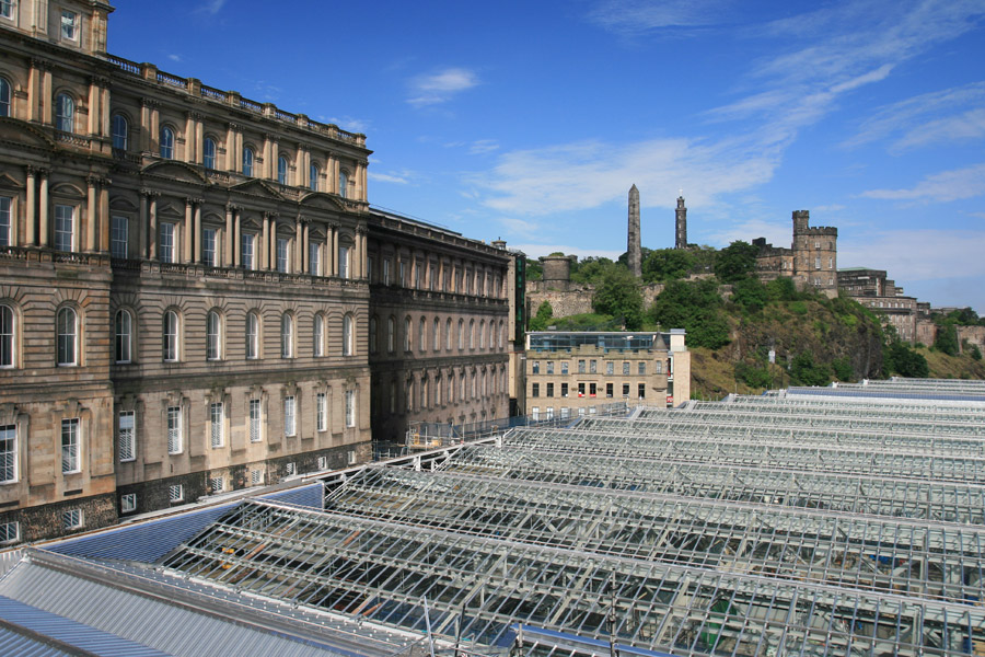
It stood in the vicinity of the building now known as Waverley Gate, formerly the General Post Office, although the exact location is unclear. Some time between the late 16th century and the mid-17th century the castle became ruined, suggesting perhaps that it dated to earlier than the 16th century.

It is depicted on a James Gordon map from 1647 as a large, square courtyard castle, with a round tower at each corner, except for the north-east corner where the outer half of the tower is missing. The style of the castle on the map backs up the theory that it pre-dated the 16th century.

It stands in a large plot of land at the northern extremity of Edinburgh, and the plot is surrounded by a wall. At the south-east corner of the plot is the Trinity College Church.

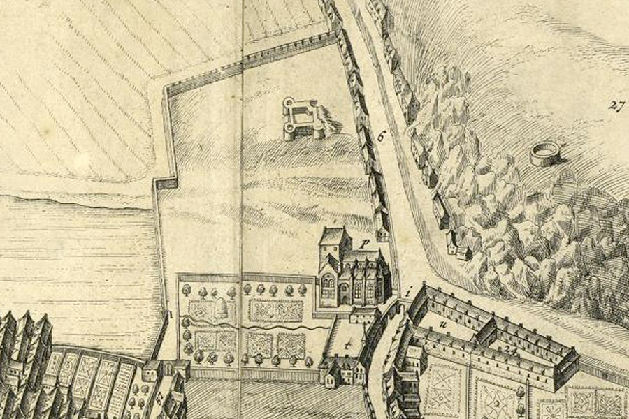
Comparing the position of the Trinity College Church to the corner of Calder Road as it curves around the bottom of the rocky crags below what is now Old Calton Cemetery, and the position of the castle in relation to the church, and also to the Nor’ Loch (later drained, and now Princes Street Gardens), it would seem that Dingwall’s Castle must have stood slightly further north than it is listed by the RCAHMS (grid reference NT 2590 7394).

Why the castle fell into ruins is unclear, but when Edinburgh was under siege between 1571 and 1573, Dingwall’s Castle was used first as a blockhouse, then later as a prison, and this may well have hastened its demise.

It would probably have required a significant investment to return the castle to a state fit for an important gentleman, but also in the late 16th and early 17th centuries tastes changed from castle living to the more fashionable mansion houses and townhouses.

Some of the stones from the castle were apparently used for the repair of Trinity College Church in 1643. Between 1734 and 1736 an Orphan Hospital (later renamed the Dean Hospital) was built close to the west end of the Trinity College Church on land named “Dingwall”.

It seems to have been concluded by some authors in the past that this meant that the Orphan Hospital was built on the actual site of the castle. However I believe that the Hospital was probably built within the castle plot rather than on the actual site of the castle itself.

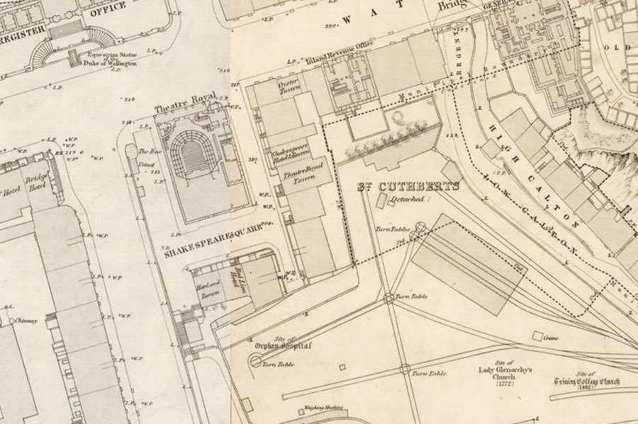
With the expansion of the railways, the site was cleared in 1845, and the site of the Orphan Hospital and the Trinity College Church are both shown on an Ordnance Survey town plan of Edinburgh from 1852.

If Gordon’s map is relatively accurate, the position of the north bank of the Nor’ Loch in relation to the castle suggests that the castle stood approximately in line with modern day Princes Street, or possibly slightly south of it. This would place it either directly under Waterloo Place, or again just to the south of it.

In Cassell’s “Old and New Edinburgh” it mentions that sections of the castle’s walls could be seen amongst the foundations of the buildings of Shakespeare Square when they were demolished in 1860 to make way for the new General Post Office building, which was begun in 1861.

This piece of history is repeated in “Modern Edinburgh”, which places the site of Dingwall’s Castle to the south of Mutrie’s Hill. Mutrie’s Hill was an old village that was just outside Edinburgh and the site of which is now occupied by the modern St. James Square.

On the southern side of Mutrie’s-hill, and still nearer the old town, stood an ancient fortalice, called Dingwall’s Castle, as is believed, from John Dingwall, provost of Trinity College, and archdeacon of Caithness . . . . The last remains of the old castle only disappeared on the erection of Shakespeare-square, a portion of its walls being indeed believed to be still extant in one of the cellars there.

Modern Edinburgh
London, 1854

Again, this suggests that Dingwall’s Castle stood in the vicinity of today’s Waverley Gate building or Waterloo Place, rather than further south. The combination of Gordon’s map, and the accounts of the castle’s foundations being visible in what was Shakespeare Square, means I have placed the site of the castle just to the east of the old GPO.

stay in a castle
  • advertisement/

Alternative names for Dingwall Castle

Dingwall's Castle

Where is Dingwall Castle?

Dingwall Castle is in the parish of Edinburgh and the county of Midlothian.

Grid reference: NT 2593 7397

Lat / long: 55.953023, -3.18773

  • advertisement
Bing Maps | Google Maps | Historic maps (NLS) | OpenStreetMap | Ordnance Survey | PastMap | Streetmap | Wikimapia

OS Map for Dingwall Castle

OS map 350
Edinburgh (Musselburgh & Queensferry)
OS Explorer map 350


  • advertisement

Directions to Dingwall Castle

Enter a starting point

  • advertisement

Weather at Dingwall Castle

8°C
max 9°C / min 8°C
3km/h W
1029mb
81%
100%
04:00 20:18

Overcast clouds
Weather observed at Edinburgh at 05:54
  • advertisement

References (books)

Cassell's Old and New Edinburgh, Volume 3
James Grant
London, 1883
Modern Edinburgh
The Religious Tract Society
London, 1854
The Scottish Nation, Volume 2
William Anderson
Edinburgh, 1877
Traditions of Edinburgh, Volume 1
Robert Chambers
Edinburgh, 1825

References (websites)

Canmore

Castles near Dingwall Castle

Edinburgh Castle

0.9km away

Holyroodhouse

1.0km away

Croft an Righ

1.0km away

Valleyfield House (possible) (site of)

1.7km away

East Coates House

1.9km away

Pilrig House

1.9km away

Burgh Muir Castle (site of)

1.9km away

Inverleith (site of)

1.9km away

Lochend Castle

1.9km away
more castles....
  • advertisement

Ancient sites near Dingwall Castle

Edinburgh Castle fort

0.9km away

Arthur's Seat fort

2.1km away

Samson's Ribs fort

2.2km away

Dunsapie fort

2.4km away

Buck Stane standing stone

4.9km away

Wester Craiglockhart Hill fort

5.0km away

Caiy Stane standing stone and rock art

5.9km away

Cat Stanes (site of) cairns

5.9km away

Camus Stone (site of) standing stone

6.0km away
more ancient sites....
  • advertisement

Pictish stones near Dingwall Castle

Abernethy No. 2 Class III symbol stone

0.7km away

Abernethy No. 4 Class III cross shaft

0.7km away

Princes Street Gardens Class I symbol stone

1.0km away

Court Cave Class I rock carving

24.4km away

Doo Cave Class I rock carving

24.5km away

Jonathan's Cave Class I rock carving

24.8km away

Sliding Cave Class I rock carving

24.8km away

Scoonie Class II cross slab

30.4km away

East Lomond Hill Class I symbol stone

32.2km away
more Pictish stones....
  • advertisement

Pictish sites near Dingwall Castle

Haddington silver chain

25.5km away

Traprain Law silver chain

32.3km away

Borland silver chain

34.0km away

Whitlaw silver chain

35.3km away

Todholes (possible) silver chain

35.8km away

Norrie's Law hoard

36.6km away

Hoardweel silver chain

54.5km away

Whitecleugh silver chain

70.0km away

Dunnicaer fort

127.2km away
more Pictish sites....

Accommodation near Dingwall Castle

Princes Street Suites
self-catering apartmentsEdinburgh
0.1km away
Apex Waterloo Place Hotel
hotel, restaurant, barEdinburgh
0.1km away
The Balmoral Hotel
hotel, restaurant, barEdinburgh
0.1km away
Haggis Hostels
hostelEdinburgh
0.2km away
Parliament House Hotel
hotel, restaurant, barEdinburgh
0.2km away
Unite 3 - James Craig Court
hostelEdinburgh
0.2km away
Princes Street East Backpackers
hostelEdinburgh
0.2km away
Jurys Inn Edinburgh
hotelEdinburgh
0.2km away
Royal British Hotel
hotelEdinburgh
0.2km away
The Scotsman Hotel
hotel, restaurant, barEdinburgh
0.2km away

Accommodation search

(leave blank to view all)
Accommodation type
bed and breakfasts
campsites
castles
holiday parks
hostels
hotels
self-catering apartments
self-catering cottages
self-catering lodges
spas
  • Booking.com
more accommodation....

Cafés, restaurants & bars near Dingwall Castle

Apex Waterloo Place Hotel
hotel, restaurant, barEdinburgh
0.1km away
The Balmoral Hotel
hotel, restaurant, barEdinburgh
0.1km away
Pivo
barEdinburgh
0.1km away
Black Bull Tavern
barEdinburgh
0.1km away
Guildford Arms
pub, restaurantEdinburgh
0.2km away
Parliament House Hotel
hotel, restaurant, barEdinburgh
0.2km away
North Bridge Brasserie
restaurantEdinburgh
0.2km away
The Scotsman Hotel
hotel, restaurant, barEdinburgh
0.2km away
The Carlton Hotel
hotel, restaurant, barEdinburgh
0.3km away
St Christopher's Inn - Edinburgh
hostel, barEdinburgh
0.3km away
more food.... / more drink....

Related pages

Dirleton Castle in East Lothian
Garden of Cosmic Speculation plus castles
Inveraray Castle and standing stone
A doocot, a castle and a beach in East Lothian
A pair of castles on the River Tweed
Dunbar harbour and castle
Published on the 14th of May 2010 at 1:57 pm. Updated on the 31st of May 2016 at 1:01 pm.

Leave a comment

back to the top of the page

Connect with us

Like us on Facebook

Receive our newsletter

Follow us on Twitter

Tweets by Stravaig_Aboot

Quick links

Stay in a Scottish castle
Edinburgh Festival accommodation
Hotels in Scotland
Car hire in Scotland
Places to eat and drink in Scotland
Castles in Scotland
Trace your Scottish ancestors
Scottish clans
Standing stones in Scotland
The Picts
Pictish symbol stones
Pictish placenames
Scottish bands and musicians
Scottish films
Scottish TV shows
West Highland Way

About

Andy Sweet above Fast Castle

Stravaiging around Scotland is written, photographed and researched by Andy Sweet.
read more....

Cookies

To make this site work properly we use cookies to store information on your computer. Click here to read more.

Affiliate links

This site includes affiliate links and adverts. If you click on these links we may receive a small commission at no cost to yourselves. As an Amazon Associate we earn from qualifying purchases. This modest income goes towards funding the site.
© 2003 - 2025 Andy Sweet / Stravaiging around Scotland. Powered by WordPress. Hosted by Tsohost.