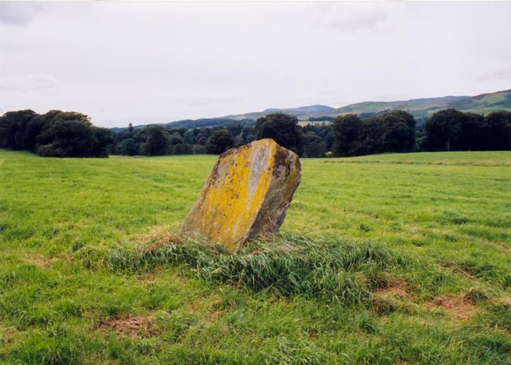
This 1.70m tall standing stone stands to the north-west of the Monzie kerb cairn, linked by the drive which meanders in an S-shape between these ancient monuments on its way to Monzie Castle.
In 1936 the stone stood “in the middle of a causeway 6 yds wide, like a Roman road” but there is no visible evidence of this now. Also disappeared is a possible barrow immediately the to the south-east of the stone, which has presumably been ploughed away. The stone leans heavily to the north, away from Kate McNieven’s Craig which points towards the Witches’ Stone from the Knock of Crieff.
Kate McNieven is supposedly the witch who gave her name to the stone, although there are some doubts about her existence, and the name is plural. Tradition has it that the Craig is where she was burned (for turning herself into a bee and buzzing around the head of Graham, laird of Inchbrakie). She is supposed to have been one of the last witches burned in Scotland, but one account has her being burned as early as 1563, while another says that she was burned in St Andrews.


Alternative names for Witches' Stone
Monzie Castle
Where is Witches' Stone?
Witches' Stone is in the parish of Crieff and the county of Perthshire.
Grid reference: NN 8798 2431
Lat / long: 56.39773256, -3.81639058
OS Map for Witches' Stone

OS Explorer map OL47
Buy from Ordnance Survey
Directions to Witches' Stone
Enter a starting point

Weather at Witches' Stone
max 6°C / min 6°C
992mb
77%
100%
08:19 15:47
Overcast clouds
Weather observed at Crieff at 04:44


