Corbet Tower or Corbethouse is a 16th century tower house which latterly belonged to the Ker family.
The tower is said to originally have been a possession of the Corbets and that that is how it came by its name. The Corbet family were certainly resident in this general area of the Borders, holding the lands of Morebattle immediately to the north-west of Corbet Tower in the 12th century. They also held Makerstoun, around 12km to the north-west of Corbet Tower, at a similar time and land at Clifton to the east in the early 13th century.
There were lands somewhere in this area called Corbet which seem to have been held by the Charteris family in the 15th century although where exactly they were located is unclear, perhaps somewhere near Morebattle and Corbet Tower. It is tempting to speculate that Corbet Tower, or more correctly its predecessor, was originally the principal seat of the lands of Corbet.
The tower stands at the top of a sleep bank which slopes down to the valley of the Kale Water to the east, with the flanks of Morebattle Hill rising to the west.
In May 1426 Thomas Charteris of Cagnore and Kinfauns resigned the lands of Grubet, Yhethame, Corbet, Holden and Turfimuiresyd and they were granted to Nicholas de Rwthirfurde. On the same day Charteris also resigned the lands of Malcarstoun, once a property of the Corbets, which were likewise granted to Nicholas Rutherfurd. It would seem that Charteris held the old lands of the Corbets.
It has been suggested that Corbet Tower was the original fortalice of the neighbouring lands of Gateshaw to the south although there doesn’t seem to be any strong evidence that points to this. Certainly it was later a part of the Gateshaw estate but in the mid-15th century the lands of Gateshaw were held by Thomas Ker of Gateshaw, suggesting that they were separate lands to those of Corbet held by Nicholas Rutherfurd.
The lack of visible remains of a tower at Gateshaw itself, and the later absorption of Corbethouse into the Gateshaw estate, may have led to the belief that Corbet Tower was the original tower of Gateshaw.
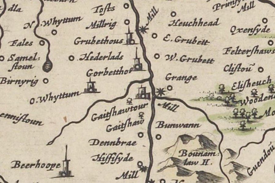
Unfortunately the first detailed map evidence for the area doesn’t occur until Blaeu’s Atlas of Scotland in the mid-17th century. It would seem to be clear that Corbet Tower is represented by the tower named Gorbettho which is shown to the north of a tributary of the Kale Water, presumably the Corbet Burn, to the north-east of O. Whyttum (now Whitton), to the north of Gaitshawtour and to the west of the settlement of W. Grubett across the river. E. and W. Grubett can perhaps be equated with Over and Neyther Grobet. Further north, across the Kale from Grubbit Mill, is another apparent tower named Grubethous.
By the early 16th century however Corbet was in the possession of the Kers as in 1502 Andrew Ker of Corbet had a black horse stolen by a gang of Nixons organised by Matthew and Robert Oliver.
In April 1522 an English force under Sir Anthony Ughtred “burnt the tower of Gaitshaw, and divers steads and hamlets” in retaliation for a raid into Northumberland by Lancelot Ker of Gateshaw. Subsequently Gateshaw is said to have been “strengthened with the addition of another peel” which was known as New Gateshaw.
George Ker of Corbethouse received a charter of the lands of Corbethouse in 1526.
Some sources equate Corbet Tower with the “tower of Gaitshaw” that was burnt in 1522 and suggest that the New Gateshaw tower was built some 1.5km to the south in the vicinity of the present Gateshaw House.
However a list of “towns and steads” burnt by the English in the area on the 4th of July 1544 includes “Shapeley, Hownomkirk, Hownom Town, Hevesyde, Overgatesyde, Nethergatesyde, Corbet House, Grawbet Haugh, Mylberie, Growbet Mylne, both Growbetts, Hownome Graunge, the Deane Bray, Blake Jaks houses.” Following their progression north along the Kale Water from Hownam and Heavyside it would suggest that Overgatesyde and Nethergatesyde represent the old and new Gateshaws while Corbet House is listed separately.
The damage done to the tower of Corbet may have been severe as it was omitted from a list of places that were “brent, raced, and cast downe” in September 1545 by an English army led by Edward Seymour, Earl of Hertford. The places burnt along the Kale Water are divided into different groupings. The first group comprises of Over-Hownam, Neyther Hownam, Hownam Kyrke and Newe Gateshaughe, while the second includes the Towre of Gateshaughe, Over Grobet and Neyther Grobet. The third group progresses from Grobet Mylne to Wydeopen, Crewkedshawes and Prymside, making it clear that the English had crossed the Kale Water to the east and started moving away from Corbet.
Over-Hownam and Neyther Hownam were most likely in the vicinity of Hownam village, where the church of Hownam Kyrke was (and is) located. Newe Gateshaughe may have been located somewhere around the present Gateshaw House. The Towre of Gateshaughe is then grouped with Over Grobet and Neyther Grobet, although the reason for this separation isn’t clear with the two Grobets being located on the east side of the Kale.
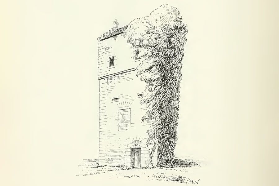
Corbet Tower is likely to have been rebuilt following the English raids. The tower measures around 6.8m north to west by around 5.0m east to west and is constructed of local whin rubble with red sandstone dressings. Towards the south end of the west façade is an entrance at ground floor level featuring a roll-moulded surround above which is a carved lintel, more of which later.
The doorway features a rebate on the outside for an iron yett and another on the inside for a wooden door and leads straight into a chamber occupying the whole of the ground floor. The south wall is pierced by a slit window while the north wall features a splayed gunloop. At the south-east corner of the chamber a spiral staircase, possibly an early 20th century addition, leads up to three further storeys and a garret.
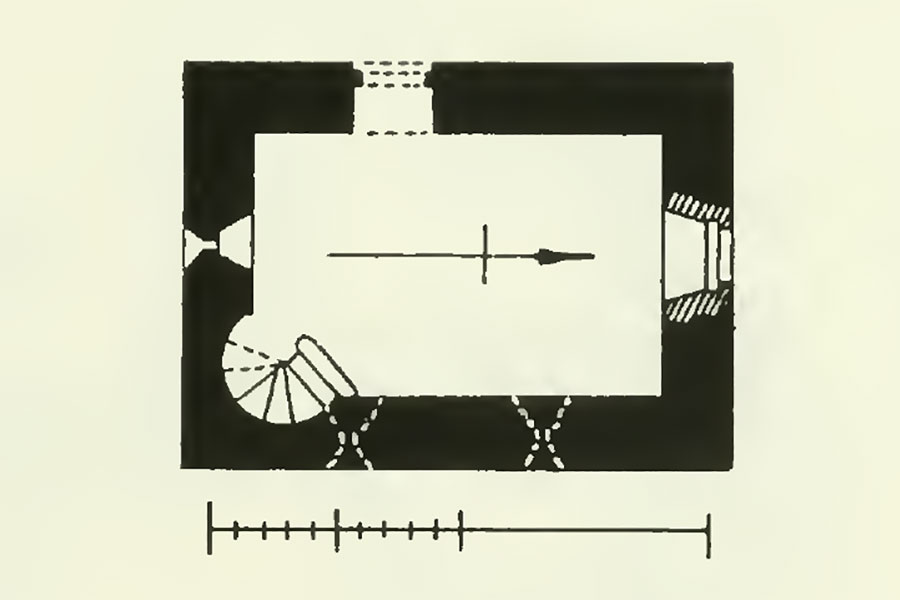
The ground floor may originally have been for storage as there is a second entrance above and to the left, now blocked up, at first floor level. Although reminiscent of the arrangement at Cessford Castle it’s possible this may be an early 19th century addition. Above this second entrance are two further splayed gunloops, with another two found flanking a small window in the north wall. On the east wall some six more splayed gunloops are to be found. Some of the gunloops are early 19th century replicas of originals.
Above the second floor the walls are built out slightly on a corbel course. The tower is originally thought to have had a parapet walk but later remodelling has left it with low-set gables crowned by stone crosses at the north and south ends of a shallow-pitched roof. The compact size of the tower has led to the suggestion that it is the remaining wing of a larger L-plan structure, the main block of which would likely have extended west from the north end of the tower.
By this time Ker of Corbethouse and Ker of Gateshaw were distinct but related branches of the wider Ker of Cessford family. There was a long-running feud between the Kers of Cessford and the Scotts of Buccleuch and in 1553 or 1554 “Johnne Ker of Corbethous” was included on a list of Kers who pledged not to harm the Scotts or their followers.
In 1558 Andrew Ker of Corbethouse, son of George Ker of Corbethouse, was murdered by John Rutherford of Hunthill and was succeeded by his brother, James Ker. James was presumably the Ker laird of Corbethouse who was taken prisoner following a skirmish between a Scottish and French party from Eyemouth and an English group on Norham Chase, near Berwick, along with the Ker lairds of Littledean, Shielstockbraes and Lochtower, the Rutherfords of Edgerston, Hundalee, Hunthill and Nisbet and Young of Otterburn.
On the 6th of June 1560 an agreement was signed between the Kers and the Rutherfords to end the feud which stemmed from the murder of Andrew Ker of Corbethouse. One of those named on the agreement was James Ker of Corbithows who agreed to his daughter, Haufie, marrying William Rutherford, 2nd son of John Rutherford of Hunthill.
Similarly on the 22nd of March 1564 the Kers of Cessford signed an agreement with the Scotts of Buccleuch pledging not to attack one another. The Kers of Corbethouse didn’t sign the bond but instead James Kerr of Corbett signed a separate agreement with Andrew Kerr of Hirsell under the terms of which they were required to apologise to the Scotts at the kirk of Melrose.
Following the murder of William Ker, abbot of Kelso, in August 1566 by his kinsmen, the Kers of Cessford, “Ker of Corbet, Mowe of that ilk, and certane others” were accused of taking lands that belonged to Kelso Abbey.
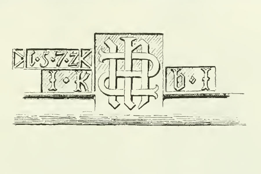
Corbet Tower may have been remodelled in 1572 as a lintel carved with that date can be found inserted above the ground floor doorway, although the date carving is positioned in such a way that it may represent a later addition to an earlier piece of carving. At the centre of the carving are the entwined letters IHS representing the first three letters of the Greek name of Jesus, ΙΗΣΟΥΣ. Flanking this are the initials IK on the left and damaged initials of BI or BK on the right.
The IK probably represents a John or James Ker and the BI or BK presumably represents his wife. The laird of Corbethouse in 1572 was James Ker who was married to Elizabeth Ker, daughter of Gilbert Ker of Heiton. If the second set of initials are BK they may possibly relate to (Eliza)beth Ker, although they had two sons named John and James whose wife’s names don’t seem to be recorded. It’s also possible that the initials refer to an earlier laird some time before 1572.
In 1609 John Ker of Corbethouse married Isabel or Isobel Kerr, daughter of William Kerr of Ancram and Woodheid and Margaret Dundas of Fingask. Possibly around the same time William Ker, younger son of James Ker of Corbethouse, married Isobel Whitelaw, co-heiress of Whitelaw and former wife of Andrew Ker of Fenton, brother of Mark Ker, 1st Earl of Lothian.
John Ker of Corbet and his brother, Thomas, were accused in July 1621 by Stevin Bambroch in Haughhead and his wife, Isobel Rutherford, of breaking into their house in May of that year along with 21 other men, 12 of whom were Kers. They were accused of giving them “ane number of baugh bla and bluidie straikis” and breaking the “kistis and the haill rest of the timber warke” in the house. The attack seems to have been the culmination of an attempt to drive the Hall family out of Haughhead.
The Kers of Corbethouse may have encountered some financial problems as in the mid-17th century Sir William Ker of Corbethouse seems to have wadset some of his lands although I haven’t been able to ascertain if this included Corbethouse. Corbethouse was later acquired by William Moir of Otterburn, son of Thomas Moir, minister of Morebattle, and Isabel Ker. Following William’s death Corbethouse passed to his widow, Dorothy or Dorothea Ker, in September 1673.
Around 1676 her son, Thomas Moir of Otterburn and Corbethouse, registered arms and in April 1687 Corbethouse was officially disponed to him. Thomas was succeeded by his son, also Thomas, who died in 1756 and was succeeded by his son, Andrew. Andrew’s son, another Thomas Moir of Otterburn, had his estates sold by judicial sale in December 1765 and Corbethouse was acquired by William Kerr, a former Town Clerk of Kelso and Chamberlain to John Ker, 3rd Duke of Roxburghe, who had bought the neighbouring estate of Gateshaw in 1758.
It isn’t clear if Corbet Tower was still occupied at this time, or if a new house had been built nearby. William may have been responsible for building a walled garden and stables to the north-west of the tower and it’s possible that a new house could have been built around this time, likely to the south-west of the tower.
William Kerr of Gateshaw died in 1794 and was succeeded by his son, Gilbert, who subsequently got into financial difficulties. In 1801 Gilbert’s brother, Charles Ker, M.D., Assistant Inspector of Hospitals for the Army Medical Department, bought Gateshaw, and presumably Corbet Tower, from his brother’s trustees.
Following his retirement in 1815 Charles Ker drastically remodelled Corbet Tower as a belvedere, altering the north wall, removing the parapet walk and adding the aforementioned low-set gables topped off with stone crosses. Reused red sandstone was employed as rubble while the new dressings were cut from grey sandstone. It may also have been at this time that the original main block of the castle was removed leaving just the smaller wing. This would suggest that there was indeed a new house nearby.
Charles Ker was knighted by George III “for his distinguished services” in 1822 and in 1835 executed a disposition of his estate in favour of his nephew, Gilbert’s eldest son, William, a merchant in Liverpool. Two years later Sir Charles died unmarried and William succeeded to Corbethouse and Gateshaw.
William Ker had married his cousin, Jane, third daughter of Ellis Martin. Little seems to be written of Corbethouse over the next half century or so, but it seems apparent that its fate was entwined with that of Gateshaw. When William died in 1864 he left Gateshaw in liferent to his widow and feu to his second son, Ellis Martin Ker, and it would appear that this included Corbethouse.
In 1873 Ellis Martin Ker sold Gateshaw, and possibly Corbethouse too, to Christopher Douglas of Chesterhouse, Writer to the Signet, for £36,000. Douglas died in November 1894 and was succeeded by his brother, Alexander Sholto Douglas of Chesterhouse and Gateshaw.
In 1896 Alexander commissioned Hardy & Wright to build the asymmetrical, two storey and attic shooting lodge of Corbet House to the south-west of Corbet Tower, possibly on the site of a late 18th century predecessor. Around 1900 Corbet Tower’s interior was refurbished and the spiral staircase in its south-east corner may have been added at this time.
Alexander Sholto Douglas died in August 1916 and was succeeded by Robert William Cowan, a first cousin once removed of Douglas’s wife, Helen McCaul Forrester. Under the terms of the will Cowan assumed the additional surname of Douglas, becoming Robert William Cowan-Douglas. Robert died at Corbet House in 1934 and was succeeded by his son, Captain John Robert Cowan-Douglas of Gateshaw.
The by then Major Cowan-Douglas, who resided at Gateshaw House, died in 1970 but at what point Corbet House and Corbet Tower passed out of the Cowan-Douglas family I have not been able to ascertain. Certainly it was no longer in the family by 2004 and the property remains a private home.


Alternative names for Corbet Tower
Corberthouse; Corbet House; Corbet-house; Corbeth; Corbethous; Corbethouse; Corbethouse Tower; Corbethousis; Corbett; Corbett Castle; Corbetthous; Corbit house; Corbithows; Corbytt; Gateshaw; Gorbettho