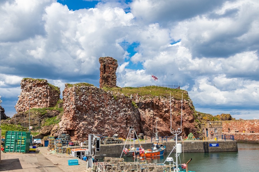
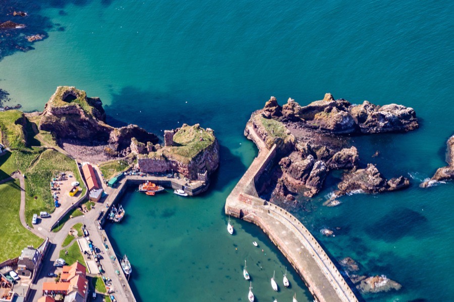
Dunbar Castle is a ruined castle guarding the entrance to a harbour, and while the remains are largely from the 13th to 16th centuries the site has a much longer history.
Immediately to the south of the castle was an Iron Age promontory fort, protected by three defensive ditches which have been dated to between AD 120 and 500. The site was of strategic importance to the Kingdom of Bernicia in the 6th century and to its successor the Kingdom of Northumbria in the 7th century. During the mid-9th century it was burnt and later occupied by Kenneth MacAlpin as the Scots harried the north of Northumbria.
Following the collapse of Northumbria in the mid-10th century Dunbar came firmly under Scottish rule and in 1005 Patrick de Dunbar was killed fighting for Malcolm II against Norse invaders. Gospatric or Cospatric, Earl of Northumbria, was exiled in Scotland following a failed uprising against William the Conqueror in England in 1072 and was granted Dunbar and its neighbouring lands by Malcolm III. He had three sons, Gospatric II, Dolfin and Waltheof, and a daughter, Uchtreda, who married Malcolm’s son Duncan (later Duncan II). Some sources speculate that Gospatric may have built the first stone castle at Dunbar.
It is perhaps more likely that one of Gospatric’s descendents built the first stone castle in the mid-12th century, perhaps Gospatric II (died 1138) or Gospatric III (died 1166). All three Gospatrics were styled Earl of Lothian, with Gospatric III’s son, Waltheof (died 1182), the first to be styled Earl of Dunbar.
Dunbar was strategically-important, being the most convenient port to the north of Berwick, and as such was frequently attacked over the centuries as the Scots and English vied with one another for control over the border areas of south-east Scotland. In January 1216 John I of England invaded Scotland, took Berwick Castle and burned Roxburgh but seemingly failed in an attempt to take Dunbar.
In 1286 Thomas the Rhymer, Thomas Learmonth of Ercildoune, visited the Earl at the castle of Dunbar and predicted the death of Alexander III.
The first specific mention of the castle in records however doesn’t happen until 1296. When Patrick, Earl of March, swore fealty to Edward I of England in March the Earl’s wife, Marjorie Comyn, daughter of the Earl of Buchan, held Dunbar Castle for the Scots. However the following month the castle was captured by the English under John de Warenne, 6th Earl of Surrey.
On the 14th of January 1304 Margaret of France, Edward I’s queen, stayed the night at Dunbar before continuing to Dirleton Castle and on to her husband in Dunfermline. Edward II fled to the castle in 1314 following his defeat at the Battle of Bannockburn and was received there by the Earl of March who helped him escape back to England. In 1333 the Earl of March slighted the castle on the approach of the English, but following the English victory at the Battle of Halidon Hill Edward III forced the Earl of March to rebuild it “at his own expense, and to admit an English garrison therein”.
Edward Balliol ceded all the lands of the Lothians to the English in 1334, including Berwick, Dunbar, Roxburgh and Edinburgh, but Dunbar seems to have been in Scottish hands once again in 1335.
In 1338 it was besieged by the English under the Earl of Salisbury. The siege lasted 5 months with Agnes Randolph of Dunbar, “Black Agnes”, the daughter of Thomas Randolph, 1st Earl of Moray, and husband of Patrick, 9th Earl of March, holding out. During the siege Sir Alexander Ramsay of Dalhousie arrived by sea and entered the castle via the postern with a party of men to bolster the defenders.
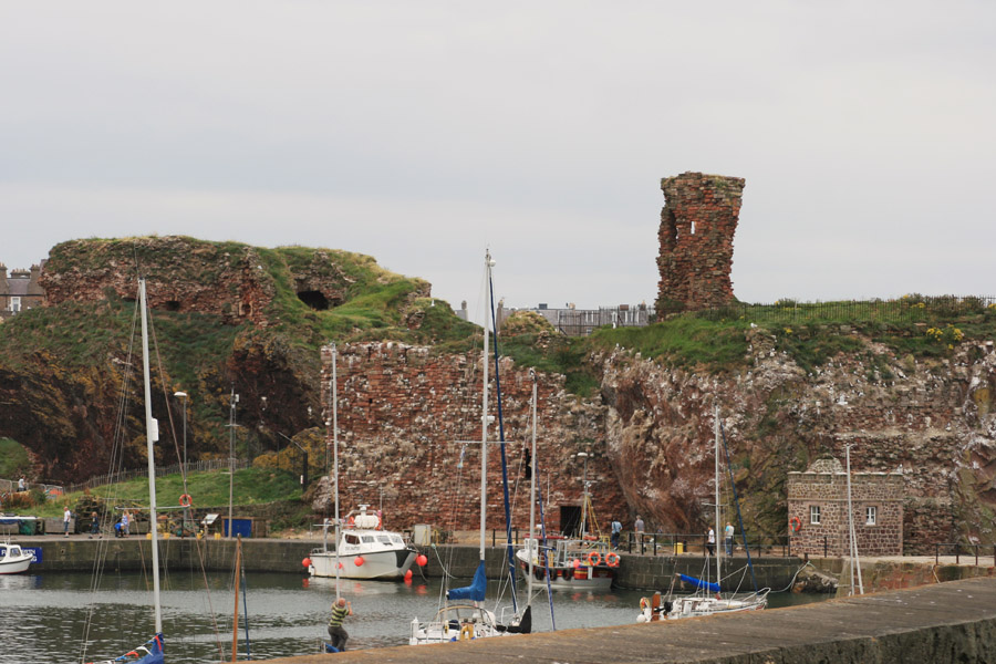
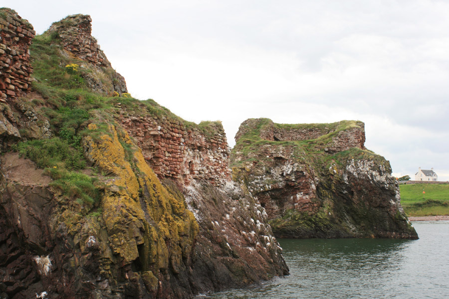
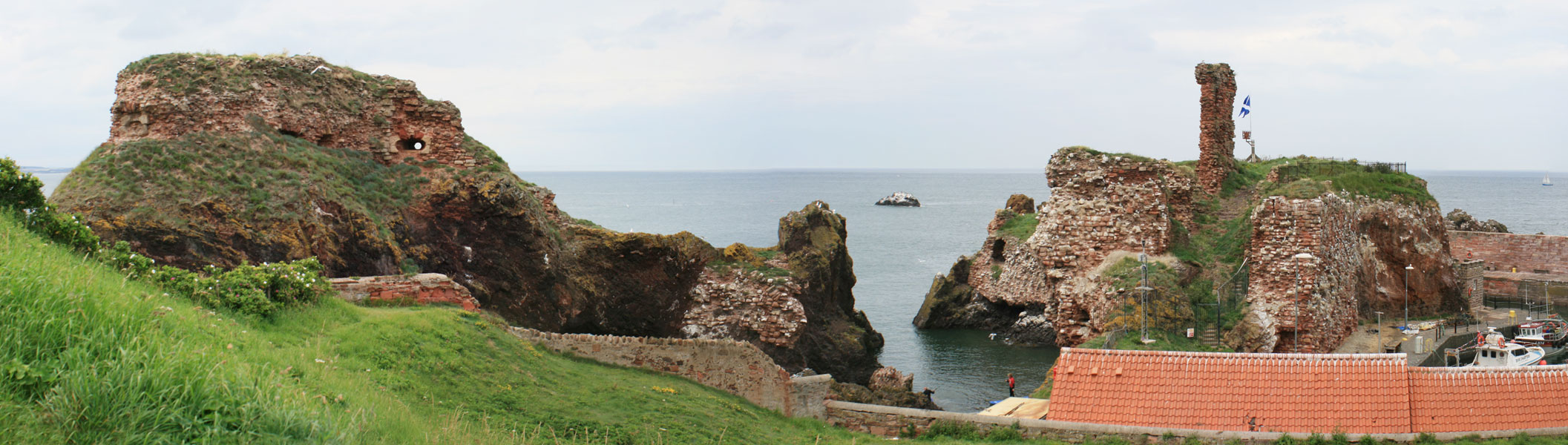
The castle occupied an area measuring some 65m north to south by 50m east to west, perched on rocky sea stacks and natural arches with walls and arches spanning the sea between them. The main keep stood on a detached, near perpendicular, rock some 22m tall and surrounded on three sides by the sea, only accessible from the south-west.
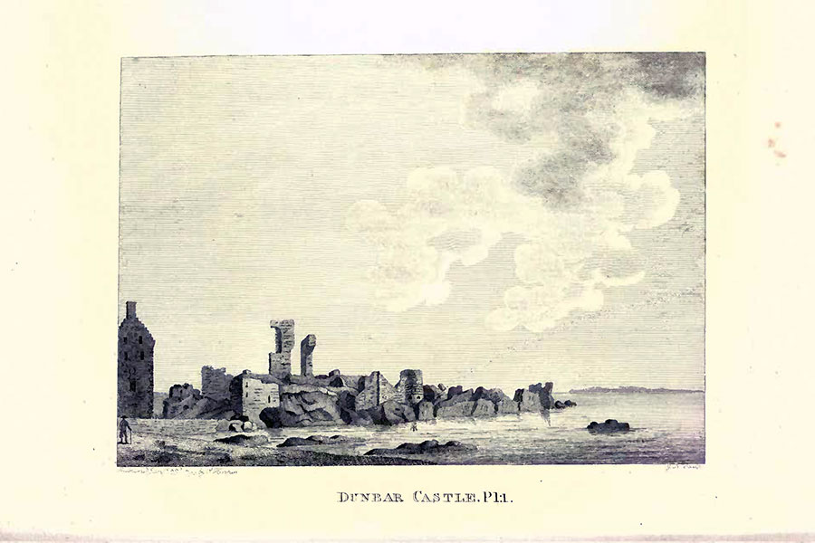
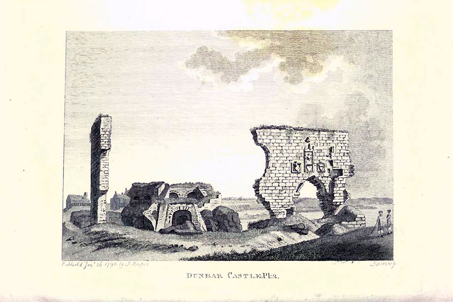
Francis Grose, London, 1797
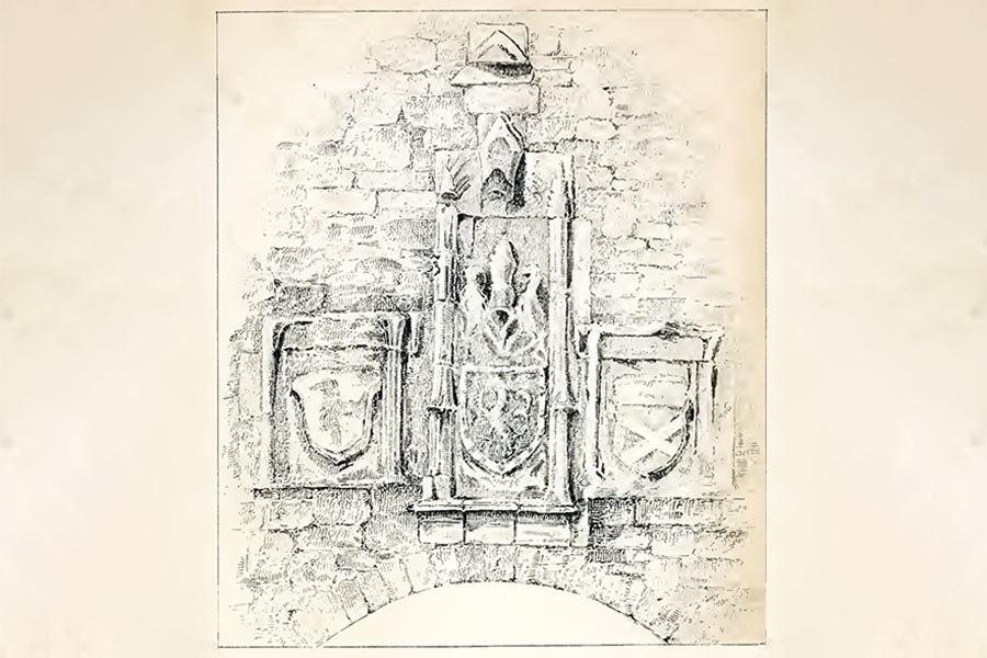
At the south-east edge of the castle, around the middle of the curtain wall, was an arched gateway over which were three carved armorial panels. The central panel was carved with the arms of Dunbar over a shield containing a Lion Rampant. The shield to the left of this panel contained the three-legged arms of the Isle of Man while the shield to the right contained the arms of the lordship of Annandale. These are thought to date to the time of George, 10th Earl of March and Dunbar, who was a cousin of Black Agnes’ husband, Patrick. Thomas Randolph, the 10th Earl’s grandfather, was made Lord of Man and Lord of Annandale.
London, 1869
The carvings were still in their original position when illustrated by Grose in 1790 but collapsed into the sea during a violent storm on the 21st of October 1869.
Francis Grose, London, 1797

London, 1869
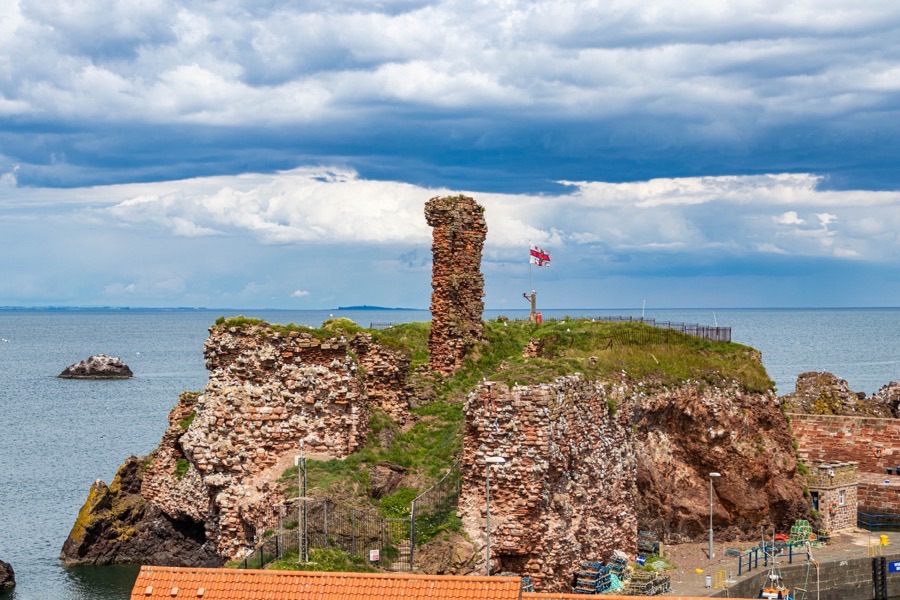
Part of the massively thick curtain wall can still be seen facing onto the harbour, with a tall pillar of masonry beyond all that remains of a building which once stood within the courtyard.
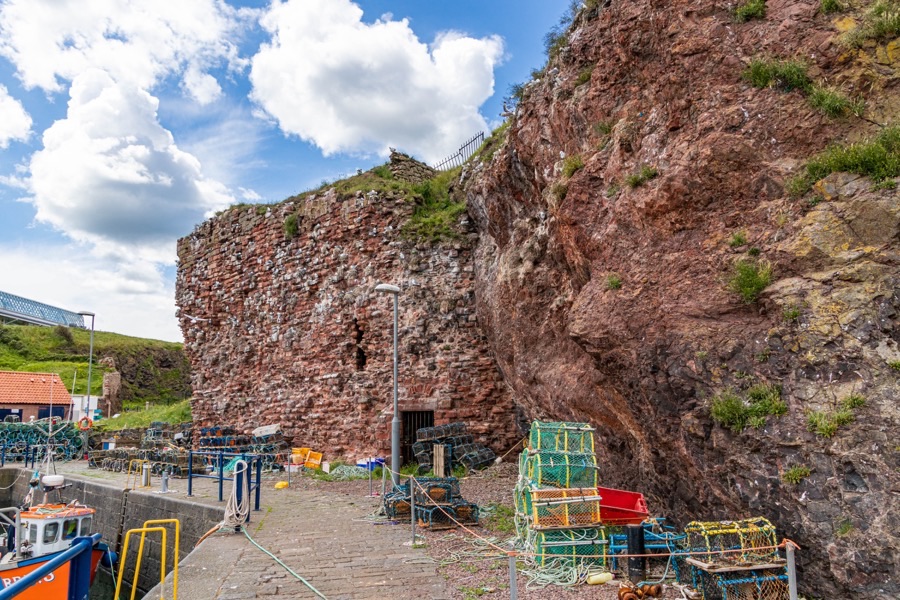
On the north-east side of the castle is a large sea cavern which was apparently used as a prison. A postern with portcullis led down to a rocky inlet. To the north-west part was a small apartment which is almost inaccessible and said to have been used at one point by Mary Queen of Scots.
By the late 14th century the Earl of March was one of the most powerful nobles in Scotland and in 1399 his daughter was due to marry David Stewart, Duke of Rothesay and son and heir of Robert III. However Archibald Douglas, 3rd Earl of Douglas or Archibald the Grim, objected and the marriage contract was cancelled with Rothesay instead marrying Douglas’ daughter Marjory. In response to this snub the Earl of March travelled to the court of Henry IV of England in July 1400, leaving his nephew, Robert Maitland of Lethington, in charge of Dunbar Castle in his absence.
Robert III sent his son-in-law, Archibald Douglas, 4th Earl of Douglas, to besiege the castle and Maitland surrendered. Over the following years the Earl of March launched several attacks on the border areas of Scotland along with Henry Percy on behalf of Henry IV, however in 1403 the Percys turned against the King who the Earl continued to support. The Earl of March was rewarded with property in England, including former Percy estates, however in 1408 he returned to Scotland in a reconciliation negotiated by Sir Walter Haliburton of Dirleton and his March estates restored by Robert Stewart, Duke of Albany, the Regent of Scotland.
During the reign of Robert III, in the late 14th or early 15th century, a Patrick Home, described as a son of the Earl of Home, appears in a fable regarding the Anstruthers of Anstruther. The title Earl of Home wasn’t created until 1605 and the title Lord Home wasn’t created until 1473 however the 10th Earl of March and Dunbar was the progenitor of the Lords Home his fourth son was named Patrick de Dunbar of Biel. Whether or not he was the Patrick of the story is unknown.
Sir William Anstruther is said to have lived at Dreel Castle in Anstruther with his daughter, Margaret, his son being at the court of Robert. Margaret is said to have fallen in love with the 22 year old Patrick Home, whose ancestor had supposedly killed Sir William’s grandfather on the Firth of Forth. The story goes that Sir William was in dispute with a neighbouring laird who seems to have had intentions regarding Margaret of which Sir William did not approve leading him to insult the laird. This prompted the laird to devise a plot to kill his neighbour.
The laird invited Sir William and Margaret to his house but a wandering beggar got wind of the plan and informed Sir William who then invited the laird to Dreel instead. When he arrived Sir William hit him over the head with an axe and killed him. Sir William vowed to repay the beggar’s kindness in warning him of the danger and did so by offering his daughter’s hand in marriage, at which point the beggar is supposed to have cast off his disguise to reveal himself to be Patrick Home.
Dunbar Castle was refortified early in the 15th century and it is from this time that the gatehouse is thought to date. The 10th Earl of March died in 1420 and was succeeded by his son, also George. The 11th Earl travelled to England twice in 1434 and with suspicions aroused he was imprisoned in Edinburgh Castle upon his return. William Crichton, 1st Lord Crichton, and Sir Adam Hepburn of Hailes Castle were sent to Dunbar Castle to demand its surrender, and Hepburn was installed as Constable of the castle.
In 1435 the Earl of March was accused of holding his earldoms and estates illegally since the Duke of Albany hadn’t had the authority to restore estates forfeited by the 10th Earl for treason. His possessions and titles passed to the Crown and he and his son, Patrick, were exiled to England. In 1448 the castle was badly damaged by the English under Henry Percy, 2nd Earl of Northumberland.
The earldom of March, and Dunbar Castle with it, passed to Alexander, Duke of Albany, the second surviving son of James II. In 1482 Albany was involved in the imprisonment of the young James III in Edinburgh Castle and formed a government in the King’s absence. James was released later that year and Albany fled to Dunbar in January 1483. By 1484 the castle was in the hands of the English again but upon Henry VII’s accession to the English throne in 1485 James III laid siege to the castle and regained possession.
In 1488 the castle was slighted by the Scots to stop the English using it, following an order from Parliament to be “cassyne doune and alutterly distroyit in sic wise that ony fundment tharof be occasioun of biging nor reparcione of the said castell in tyme to cum”. However it was restored by James IV in 1496, work which was completed in 1501. Early in the 16th century the castle was under control of John, Duke of Albany, during the minority of James V.
Antoine d’Arces, Sieur de la Bastie and Deputy Governor and Warden of Scottish Marches, was made Keeper of Dunbar Castle in December 1514. He was responsible for the design and construction of artillery fortifications at both Dunbar and Edinburgh Castle and may have designed the bulwark to the west. D’Arces was murdered by George Home, brother of Sir David Home of Wedderburn, in 1517 when his horse became stuck in boggy ground, the Frenchman’s head being cut off and displayed it on a pole in Duns.
Despite being Regent the Duke of Albany remained in France from 1517 until 1521, returning to Dunbar with an escort of French soldiers and artillery. Following another spell in France he once again returned to Dunbar in 1523 when a new blockhouse fortified with artillery was constructed: “in the samin ane great staine house and insche callit the uttivant blokehouse and garnist it with artaillze pulder and bullattis”.
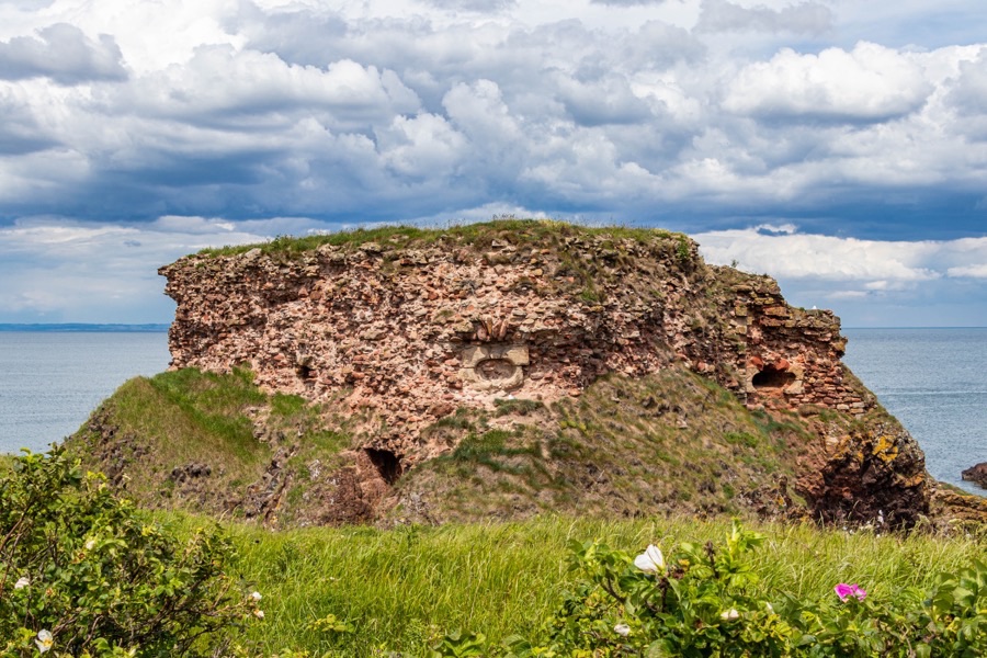
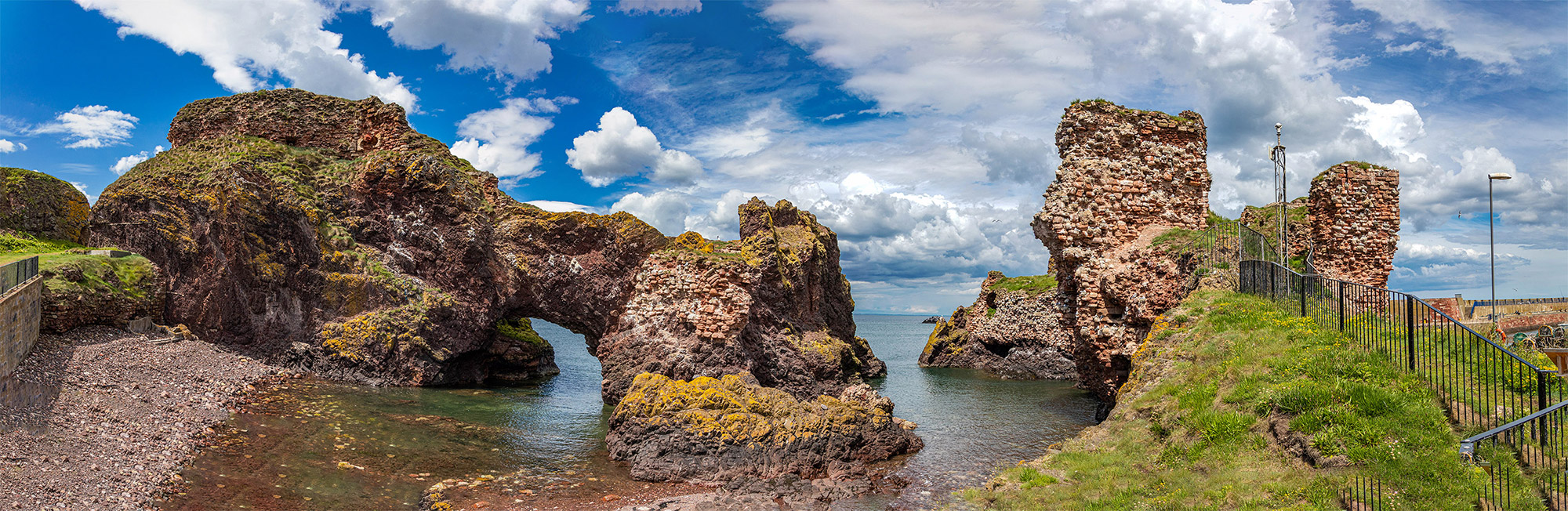
The blockhouse is a D-shaped artillery battery perched on another rock to the south-west of the main tower. The walls of the block are around 2.4m thick and contain recessed gun loops while the interior area measured around 16.5m by 18.3m.
Access to the blockhouse was via a 21m long intramural passageway within a massive screen wall of masonry connecting it to the tower. This wall has long since fallen into the sea however the opening of the passage on its east side can now be seen, as on the lower right of this image.
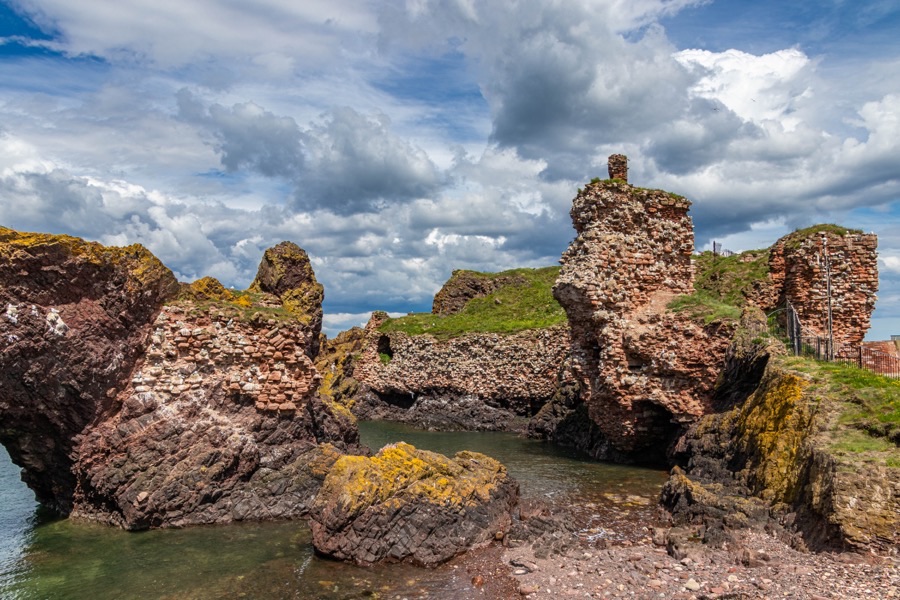
Within the wall of the corridor is a gun loop pointing towards the shore.
Albany carried out further repairs and enhancements in July 1527 and a drawing for fortifications by Antonio da Sangallo the Younger from this time may have been for Dunbar.
In 1547 during the Rough Wooing an English army under Edward Seymour, 1st Duke of Somerset, invaded Scotland but bypassed Dunbar, the castle’s garrison firing shots as the invaders made their way north. On their way home after the Battle of Pinkie in 1548 Dunbar was burnt by the English along with German mercenaries under Francis Talbot, 5th Earl of Shrewsbury. The castle was refortified later in 1548 under the direction of Piero Strozzi and Migliorino Ubaldini.
Following the destruction of Perth and Scone Abbey by a Protestant mob whipped up by John Knox in 1559, Marie de Guise, the widow of James V, mother of Mary Queen of Scots and Regent of Scotland fled to Dunbar Castle along with three hundred soldiers. Corbeyran de Cardaillac Sarlabous was the Captain of Dunbar Castle until he returned to France in September 1561. The Regent set about directing the upgrading of the castle’s defences and in 1560 the French built a new fort but it was soon demolished under the terms of the Treaty of Edinburgh.
In December 1562, two years after her mother’s death, Mary Queen of Scots visited Dunbar Castle to see her half-brother, Lord John Stewart, Prior of Coldingham. The following year George Gordon, Lord Huntly and son of the 4th Earl of Huntly, was attainted and sentenced to death for treason, however his sentence was commuted to imprisonment in Dunbar Castle (and he was restored two years later).
In 1565 Mary ordered the gun emplacements and artillery positions at Dunbar to be repaired and later that year she married Henry Stuart, Lord Darnley. On the 11th of March 1566, two days after Rizzio’s murder at Holyrood Palace, Mary and Darnley arrived to take refuge at Dunbar Castle, staying for a week.
Mary seems to have been a relatively frequent visitor to the castle, visiting again in the autumn of 1566. The following year on the 24th of April Mary was brought to the castle by James Hepburn, 4th Earl of Bothwell, following his abduction of her on her way back from visiting her son, the future James VI, at Stirling. Bothwell was the Keeper of the castle at that time and initially took her to Hailes Castle before continuing to Dunbar.
Darnley was murdered in February 1567 and on the 15th of May Mary married her husband’s likely murderer, Bothwell, at Holyrood. The marriage was understandably controversial, and with a various nobles preparing to act against Bothwell the newlyweds fled to Dunbar Castle.
Following the defeat of Mary’s supporters at the Battle of Carberry Hill on the 15th of June 1567, Bothwell returned to Dunbar Castle for the last time, later fleeing to Norway. Mary was taken to Edinburgh then on to her imprisonment in Lochleven Castle. Dunbar was held by supporters of Bothwell and in September a siege was launched by James Stewart, the Regent Moray, to eject them.
In December 1567 Bothwell’s titles and estates were forfeited and Dunbar Castle, along with the fortress on Inchkeith, was slighted by order of Parliament with the guns from Dunbar being taken to Edinburgh Castle. Following Mary’s escape from Lochleven on the 2nd of May 1568, Thomas Hepburn of Oldhamstocks attempted to retake Dunbar Castle for the Queen but was defeated in his attempts by the forces of Alexander Home, 5th Lord Home.
In September 1568 some of the castle’s stone was taken to Leith for reuse in the harbour there, and this marks the end of the castle’s life as a fortification. When the old harbour in Dunbar was renovated in the 17th and 18th centuries more stone was taken from the castle. The construction of an artillery battery on Lamer Island to the east in 1781, to defend against American pirates and French invasion, may have depleted the castle ruins further.
When the new Victoria Harbour was constructed in 1842 its entrance on the west required the castle rock to be blown up with explosives, cutting through the Great Hall and destroying most of the north-eastern half of the castle.
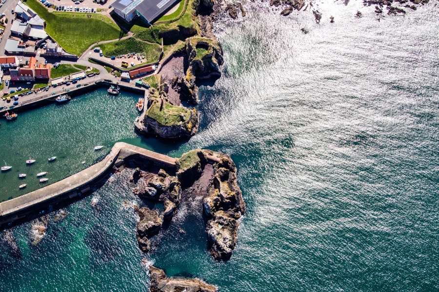
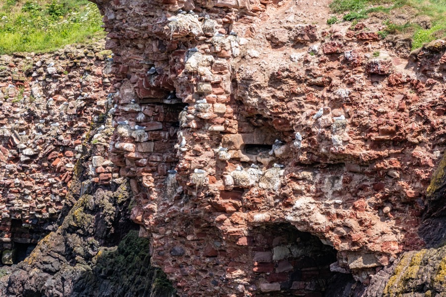
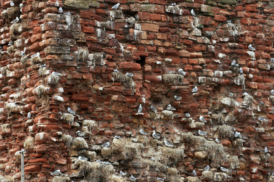
Following a collapse in 1993 public access has been forbidden but the ruins can be viewed from various points in and around the harbour. Large blocks of masonry can be seen down in the bay to the west. The castle’s walls are now home to a large colony of kittiwakes.
Click the images below for panoramic views of the castle.


Alternative names for Dunbar Castle
Castle of Dunbar; Dounbar; Dumbar; Dunbare; Dunbarre