Woodside
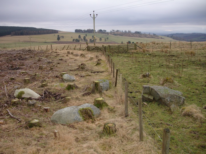
These stones lie on the edge of a forestry plantation on a high ridge. It is unclear whether the stones originally stood upright, but if they did it has been estimated that they would have formed a circle of around 6.70m diameter. The six main stones currently sit on a circle of approximately 4.80m diameter, bisected by a fence.


Alternative names for Woodside
East Drimmie Farm; Hill of Drimmie
Where is Woodside?
Woodside is in the parish of Rattray and the county of Perthshire.
Grid reference: NO 1848 5005
Lat / long: 56.63483656, -3.330431385
OS Map for Woodside
Directions to Woodside
Enter a starting point
Get directions
Weather at Woodside
8°C
max 10°C / min 7°C
max 10°C / min 7°C
10km/h ESE
1006mb
60%
90%
04:37 19:44
1006mb
60%
90%
04:37 19:44
Light rain
Weather observed at Blairgowrie at 12:28
References (books)

The Stone Circles of Britain, Ireland and Brittany
Aubrey Burl
London and New Haven, 2000
London and New Haven, 2000
References (websites)
Ancient sites near Woodside
Castles near Woodside
Pictish stones near Woodside

Pictish sites near Woodside
Accommodation near Woodside
Blairgowrie Holiday Park
4.0km away
The Royal Hotel, Blairgowrie
4.7km away
Bridge of Cally Hotel
4.8km away
Angus Hotel
4.8km away
Corriefodly Holiday Park
5.0km away
Altamount Country House Hotel
5.4km away
Old Stables Bed and Breakfast / Self-Catering
6.3km away
Alyth Hotel
6.3km away
Lands of Loyal Hotel
6.3km away
The Reid House
9.8km away
Accommodation search
Cafés, restaurants & bars near Woodside
Altamount Country House Hotel
5.4km away
Alyth Hotel
6.3km away
Lochside Lodge & Roundhouse Restaurant
10.8km away
Atholl Arms Hotel, Dunkeld
17.4km away
Dalmunzie Castle
23.2km away
Murrayshall House Hotel
24.0km away
Kinnettles Castle
24.4km away
Premier Inn Dundee West
24.7km away
Atholl Palace Hotel
24.9km away
Premier Inn Dundee North
25.3km away


