Bandirran (west)
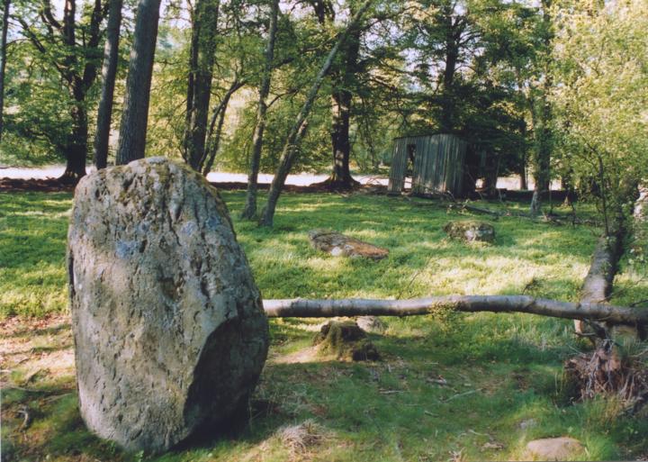
This beautifully-situated circle probably originally consisted of 10 stones on a diameter of around 85m, however there are now only 8 are now visible and only 2 still stand. The site is on what appears to be a low artificial mound (edged with stones) within a clearing in the trees. The stones that still stand were probably the tallest in the circle and are around 1.60m tall. They are on the SW arc of the circle, suggesting that the stones were graded in height in that direction, in common with other stone circles.


Alternative names for Bandirran (west)
Bandirran Western; Woodburn Cottage
Where is Bandirran (west)?
Bandirran (west) is in the parish of Collace and the county of Perthshire.
Grid reference: NO 2091 3099
Lat / long: 56.46369621, -3.28386094
Directions to Bandirran (west)
Enter a starting point
Get directions


Weather at Bandirran (west)
1°C
max 2°C / min -0°C
max 2°C / min -0°C
0km/h N
1004mb
97%
20%
08:35 16:09
1004mb
97%
20%
08:35 16:09
Fog
Weather observed at Saint Martins at 15:16
References (websites)
Ancient sites near Bandirran (west)
Castles near Bandirran (west)
Pictish stones near Bandirran (west)
Pictish sites near Bandirran (west)
Accommodation near Bandirran (west)
Perth SkyLodge
6.3km away
Murrayshall House Hotel
7.2km away
Inchture Hotel
7.3km away
Meikleour Hotel
9.3km away
The Longforgan Coaching Inn
10.1km away
Adam Guest House
10.7km away
Sunbank House Hotel
11.6km away
Salutation Hotel
11.7km away
Almond Villa B&B
11.8km away
Mercure Perth Hotel
11.9km away
Accommodation search
Cafés, restaurants & bars near Bandirran (west)
Murrayshall House Hotel
7.2km away
Breizh
11.5km away
Holiday Inn Express Perth
12.2km away
Best Western Queens Hotel & Leisure Club
12.4km away
Premier Inn Dundee West
13.8km away
Altamount Country House Hotel
14.0km away
Huntingtower Hotel
14.5km away
Best Western Invercarse Hotel
15.9km away
Premier Inn Dundee North
16.1km away
Alyth Hotel
18.0km away


