skip to main content
Menu
  • Blog
    • Art & design
    • Castles
    • Cycling
    • Edinburgh
    • Edinburgh Festival
    • Food & drink
    • General
    • History
    • Music
    • Sport
    • Walking
    • Whisky
    • Wildlife
  • Castles
    • Glossary
    • Mottes
    • Stay in a castle
    • Castle blog posts
    • Alphabetical list of castles
    • Castles divided by county
    • Photos of castles
    • Castles we've visited
  • History
    • Castles
    • Ancient history
      • barrows
      • brochs
      • cairns
      • caves
      • chambered cairns
      • cists
      • crannogs
      • cursus monuments
      • forts
      • henges
      • rock art
      • sacred sites
      • souterrains
      • standing stones
      • stone circles
    • Pictish history
      • Pictish stones
      • Pictish sites
      • Pictish placenames
    • Clans
      • Surnames
      • Trace your ancestors
      • Tartan
    • Trace your ancestors
  • Culture
    • Music
      • Bands & musicians
      • Music links
    • Film
    • Television
    • Placenames
      • Pictish placenames
  • Eat
  • Drink
    • Scottish beer
    • Scottish gin
    • Scottish vodka
  • Stay
  • Travel guide
    • City guides
    • Car hire
    • Airports
  • Walking
    • Munros
    • West Highland Way
  • Photos
  • Offers
  • Home
  • history
  • castles
Whithaughe

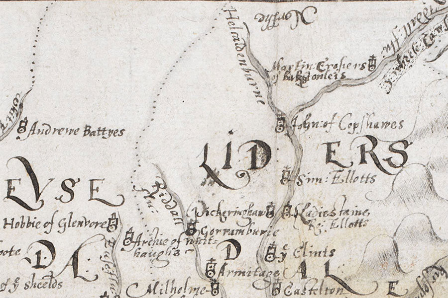
The Burghley Atlas© British Library Board, Cartographic Items Royal MS.18.d.III., f.76r

A tower belonging to Archie Armstrong once stood in this area but nothing of it now remains and its exact location is unclear.

The tower is marked as “Archie of Whithaughe” on a map of 1590 which appeared in “An atlas of England and Wales, made by Christopher Saxton”, a book owned by William Cecil, 1st Baron Burghley, and commonly referred to as The Burghley Atlas.

stay in a castle
  • advertisement/
  • advertisement

Alternative names for Whithaughe

Archie of Whitehaughe; Archie of Whithaughe; Burnfoot; Whitehaugh; Whitehaughe

Clans associated with Whithaughe

Armstrong

Surnames associated with Whithaughe

Armstrong

Where is Whithaughe?

Whithaughe is in the parish of Ewes and the county of Dumfriesshire.

Grid reference: NY 390 963

Lat / long: 55.25708, -2.9612717

  • advertisement
Bing Maps | Google Maps | Historic maps (NLS) | OpenStreetMap | Ordnance Survey | PastMap | Streetmap | Wikimapia

OS Map for Whithaughe

OS map 323
Eskdale & Castle O’er Forest (Langholm, Canonbie & Gretna Green)
OS Explorer map 323


OS map 324
Liddesdale & Kershope Forest (Newcastleton & Canonbie)
OS Explorer map 324


  • advertisement

Directions to Whithaughe

Enter a starting point

  • advertisement
  • advertisement/

Weather at Whithaughe

5°C
max 5°C / min 5°C
9km/h N
1028mb
89%
100%
04:02 20:13

Overcast clouds
Weather observed at Langholm at 03:53
  • advertisement

References (books)

A Hawick Word Book
Douglas Scott
Vancouver, 2021
Langholm As It Was
John Hyslop
Glasgow, 1912

References (websites)

Canmore

Castles near Whithaughe

Glenvore (site of)

0.4km away

Buss (site of)

4.3km away

Arkleton (site of)

5.0km away

Glendouin (site of)

5.8km away

Echizingles Tower (site of)

6.0km away

Castleweary (site of)

7.3km away

Gorrenberry Tower (site of)

7.4km away

Flask (site of)

8.5km away

Braidlie (site of)

8.8km away
more castles....

Ancient sites near Whithaughe

The Dod souterrain

12.7km away

Ninestane Rig stone circle

12.8km away

Black Rig standing stone

18.7km away

Cadgill cursus

22.9km away

Peat Rig standing stone

27.2km away

Lochbrow cursus

30.1km away

Glebe Stone standing stone

31.5km away

Warrior's Rest standing stone and rock art

31.6km away

Trailflat cursus

35.7km away
more ancient sites....
  • advertisement

Pictish stones near Whithaughe

Borthwick Mains Class I symbol stone

18.4km away

Abernethy No. 2 Class III symbol stone

78.1km away

Abernethy No. 4 Class III cross shaft

78.1km away

Princes Street Gardens Class I symbol stone

78.5km away

Trusty's Hill Class I rock carving

89.1km away

Court Cave Class I rock carving

100.7km away

Doo Cave Class I rock carving

100.7km away

Jonathan's Cave Class I rock carving

100.9km away

Sliding Cave Class I rock carving

101.0km away
more Pictish stones....

Pictish sites near Whithaughe

Whitlaw silver chain

52.6km away

Borland silver chain

59.7km away

Todholes (possible) silver chain

60.6km away

Whitecleugh silver chain

62.4km away

Hoardweel silver chain

75.1km away

Haddington silver chain

78.2km away

Traprain Law silver chain

80.9km away

Norrie's Law hoard

111.0km away

Dunnicaer fort

194.7km away
more Pictish sites....
  • advertisement
  • advertisement
  • advertisement

Accommodation near Whithaughe

Mosspaul Inn
hotelHawick
3.6km away
Liddesdale Hotel
hotelNewcastleton
12.7km away
The Cross Keys Hotel, Canonbie
hotel, barCanonbie
20.2km away
Tibbie Shiels Inn
hotel, bar, restaurant, campsiteSelkirk
28.5km away
Anvil View Guest House
bed and breakfastGretna Green
28.7km away
Hazeldene Hotel
hotelGretna Green
28.7km away
Days Inn Gretna Green
hotelGretna Green
28.7km away
Smiths At Gretna Green Classic
hotelGretna Green
28.7km away
Kirkconnel Hall Hotel
hotel, restaurant, barEcclefechan
28.8km away
Days Inn Lockerbie (Annandale Water)
hotelLockerbie
28.9km away

Accommodation search

(leave blank to view all)
Accommodation type
bed and breakfasts
campsites
castles
holiday parks
hostels
hotels
self-catering apartments
self-catering cottages
self-catering lodges
spas
more accommodation....

Cafés, restaurants & bars near Whithaughe

The Cross Keys Hotel, Canonbie
hotel, barCanonbie
20.2km away
Johnstons of Elgin Eastmill Café
caféHawick
22.4km away
Tibbie Shiels Inn
hotel, bar, restaurant, campsiteSelkirk
28.5km away
Kirkconnel Hall Hotel
hotel, restaurant, barEcclefechan
28.8km away
Best Western Dryfesdale Country House Hotel
hotel, restaurant, barLockerbie
29.0km away
Annandale Arms Hotel
hotel, restaurant, barMoffat
31.8km away
Best Western Moffat House Hotel
hotel, restaurant, barMoffat
31.9km away
Selkirk Deli
caféSelkirk
33.2km away
Best Western Philipburn Country House Hotel
hotel, restaurant, barSelkirk
33.3km away
Baxters Selkirk
caféSelkirk
34.4km away
more food.... / more drink....

Related pages

Dirleton Castle in East Lothian
Garden of Cosmic Speculation plus castles
Inveraray Castle and standing stone
A doocot, a castle and a beach in East Lothian
A pair of castles on the River Tweed
Dunbar harbour and castle
Published on the 21st of December 2011 at 12:11 am. Updated on the 20th of July 2022 at 5:13 pm.

Leave a comment

back to the top of the page

Connect with us

Like us on Facebook

Receive our newsletter

Follow us on Twitter

Tweets by Stravaig_Aboot

Quick links

Stay in a Scottish castle
Edinburgh Festival accommodation
Hotels in Scotland
Car hire in Scotland
Places to eat and drink in Scotland
Castles in Scotland
Trace your Scottish ancestors
Scottish clans
Standing stones in Scotland
The Picts
Pictish symbol stones
Pictish placenames
Scottish bands and musicians
Scottish films
Scottish TV shows
West Highland Way

About

Andy Sweet above Fast Castle

Stravaiging around Scotland is written, photographed and researched by Andy Sweet.
read more....

Cookies

To make this site work properly we use cookies to store information on your computer. Click here to read more.

Affiliate links

This site includes affiliate links and adverts. If you click on these links we may receive a small commission at no cost to yourselves. As an Amazon Associate we earn from qualifying purchases. This modest income goes towards funding the site.
© 2003 - 2025 Andy Sweet / Stravaiging around Scotland. Powered by WordPress. Hosted by Tsohost.