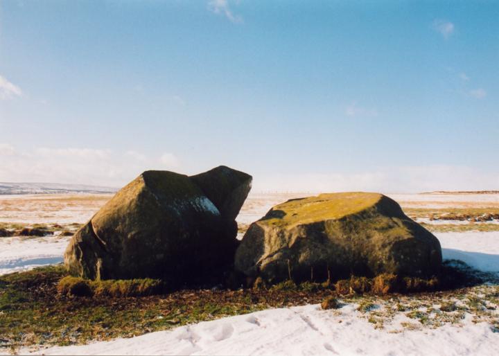
The Thorn
This enormous stone – now split in two – once stood around 3.8m high. The NE section of the boulder has eight cup-marks on it’s upper face.
In it’s original state, this stone would have been directly on a line between the Crofthead Farm standing stones and the New Fowlis cairn.


Alternative names for The Thorn
Crofthead Farm
Where is The Thorn?
The Thorn is in the parish of Fowlis Wester and the county of Perthshire.
Grid reference: NN 9204 2397
Lat / long: 56.39509497, -3.749827858
OS Map for The Thorn

Crieff, Comrie & Glen Artney (Strathearn & Auchterarder)
OS Explorer map OL47
Buy from Ordnance Survey
OS Explorer map OL47
Buy from Ordnance Survey
Directions to The Thorn
Enter a starting point
Get directions
Weather at The Thorn
13°C
max 14°C / min 12°C
max 14°C / min 12°C
6km/h WSW
1005mb
85%
100%
04:19 20:03
1005mb
85%
100%
04:19 20:03
Overcast clouds
Weather observed at Crieff at 09:21

References (websites)
Ancient sites near The Thorn
Castles near The Thorn
Pictish stones near The Thorn
Pictish sites near The Thorn
Accommodation near The Thorn
The Rowans
1.1km away
At The Willows
1.1km away
Murraypark Hotel
5.4km away
Galvelbeg House
5.6km away
Crieff Hydro Hotel and Leisure Resort
5.7km away
Crieff Hydro self-catering cottages and chalets
5.7km away
Merlindale
6.0km away
Knock Castle Hotel & Spa
6.2km away
James Cottage Guest House
6.6km away
Glendevon Hotel
11.5km away
Accommodation search
Cafés, restaurants & bars near The Thorn
Crieff Hydro Hotel and Leisure Resort
5.7km away
Knock Castle Hotel & Spa
6.2km away
Famous Grouse Experience
6.4km away
Torlum Café, Auchingarrich
14.0km away
Huntingtower Hotel
15.4km away
Holiday Inn Express Perth
17.8km away
Best Western Queens Hotel & Leisure Club
19.2km away
Breizh
19.9km away
An Lochan Tormaukin
20.7km away
Atholl Arms Hotel, Dunkeld
21.5km away


