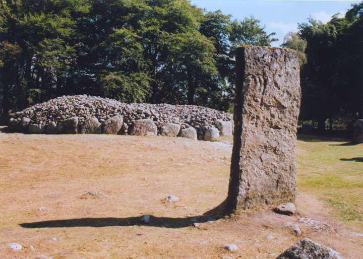
Balnuaran Of Clava, South-West

Alternative names for Balnuaran Of Clava, South-West
Clava; Clava cairns
Where is Balnuaran Of Clava, South-West?
Balnuaran Of Clava, South-West is in the parish of Croy and Dalcross and the county of Inverness-shire.
Grid reference: NH 7568 4438
Lat / long: 57.47209563, -4.074535773

OS Map for Balnuaran Of Clava, South-West
Directions to Balnuaran Of Clava, South-West
Enter a starting point
Get directions


Weather at Balnuaran Of Clava, South-West
13°C
max 13°C / min 13°C
max 13°C / min 13°C
24km/h WSW
1008mb
76%
100%
03:18 21:13
1008mb
76%
100%
03:18 21:13
Overcast clouds
Weather observed at Dalcross at 18:56
References (websites)
Ancient sites near Balnuaran Of Clava, South-West
Castles near Balnuaran Of Clava, South-West
Pictish stones near Balnuaran Of Clava, South-West

Pictish sites near Balnuaran Of Clava, South-West
Accommodation near Balnuaran Of Clava, South-West
Culloden House Hotel
4.2km away
New Drumossie Hotel
5.4km away
Castle Stuart
5.7km away
Holiday Inn Express Inverness
6.6km away
Premier Inn Inverness East
6.7km away
Glendruidh House Hotel
7.4km away
Premier Inn Inverness Centre (Millburn Rd)
7.9km away
Kingsmills Hotel
8.0km away
Chieftain Hotel
8.2km away
Inverness SYHA Hostel
8.3km away
Accommodation search
Cafés, restaurants & bars near Balnuaran Of Clava, South-West
Culloden House Hotel
4.2km away
New Drumossie Hotel
5.4km away
Premier Inn Inverness East
6.7km away
Premier Inn Inverness Centre (Millburn Rd)
7.9km away
Kingsmills Hotel
8.0km away
Heathmount Hotel
8.5km away
Crown Court Town House Hotel
8.6km away
Rocpool Reserve Hotel & Chez Roux
8.9km away
Ramada Encore Inverness
9.1km away
Glen Mhor Hotel
9.1km away


