skip to main content
Menu
  • Blog
    • Art & design
    • Castles
    • Cycling
    • Edinburgh
    • Edinburgh Festival
    • Food & drink
    • General
    • History
    • Music
    • Sport
    • Walking
    • Whisky
    • Wildlife
  • Castles
    • Glossary
    • Mottes
    • Stay in a castle
    • Castle blog posts
    • Alphabetical list of castles
    • Castles divided by county
    • Photos of castles
    • Castles we've visited
  • History
    • Castles
    • Ancient history
      • barrows
      • brochs
      • cairns
      • caves
      • chambered cairns
      • cists
      • crannogs
      • cursus monuments
      • forts
      • henges
      • rock art
      • sacred sites
      • souterrains
      • standing stones
      • stone circles
    • Pictish history
      • Pictish stones
      • Pictish sites
      • Pictish placenames
    • Clans
      • Surnames
      • Trace your ancestors
      • Tartan
    • Trace your ancestors
  • Culture
    • Music
      • Bands & musicians
      • Music links
    • Film
    • Television
    • Placenames
      • Pictish placenames
  • Eat
  • Drink
    • Scottish beer
    • Scottish gin
    • Scottish vodka
  • Stay
  • Travel guide
    • City guides
    • Car hire
    • Airports
  • Walking
    • Munros
    • West Highland Way
  • Photos
    • ancient sites
      • Dark Age sites
      • megalithic sites
      • other carved stones
      • Pictish sites
      • Roman sites
    • buildings
    • miscellaneous
    • places in Scotland
  • Offers
  • Home
  • history
  • castles

Nether Browncastle


The nether ward of Clyds-dail and Glasco
Joan Blaeu, Amsterdam, 1654map image courtesy of NLS

There was once a tower named Nether Browncastle although nothing of it now remains and the site of it is likely occupied by the farm of East Browncastle.

East Browncastle farm stands on a slight ridge to the east of West Browncastle on the west bank of the Brock Burn just to the north of its confluence with the Calder Water. Much of the surrounding landscape once consisted of boggy ground offering further natural defences.

The early history of Browncastle doesn’t seem to be known but it’s possible that due to the name it was once owned by a Broun family. The lands appear to have been divided by the late 15th century into the lands of Browncastle and those of Easter Browncastle with Browncastle being the larger of the two. The Douglas family may have owned the original lands of the unified Browncastle earlier in the 15th century but they seem to have been subdivided by the end of the century.

In 1493 Robert Douglas, the son and heir of Adam Douglas de Brouncastell, was granted by the king the 4 merk lands of Brouncastell that his father had owned. The following year an illegitimate son of James Hamilton of Torrance, also named James, received the 6 shilling, 8 penny (or half merk) lands of Estir Brouncastell from his father.

It would seem that the younger James may have disposed of Estir Brouncastell soon after as there is a sasine in the same year of the same lands, along with Peristoun in Ayrshire, to Sir Robert Cunningham, described as laird of Cunningham.

In 1497 Sir Patrick Hamilton married a daughter of Adam Douglas of Browncastle and the remaining majority lands of Browncastle seem to have passed into the Hamilton family.

Robert Cunningham of Cunninghamhead seems to have sold and alienated the 8 shilling, 4 penny lands which extended from the old Browncastle to William Schaw of Polkemmet in 1501. These may have been different, neighbouring lands to the 6 shilling, 8 penny lands of Estir Brouncastell as in 1510 the king confirmed Robert Cunningham of Cunninghamhead in various lands including those.

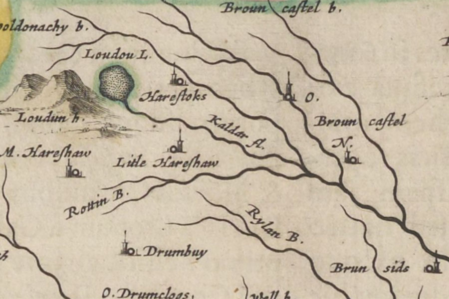
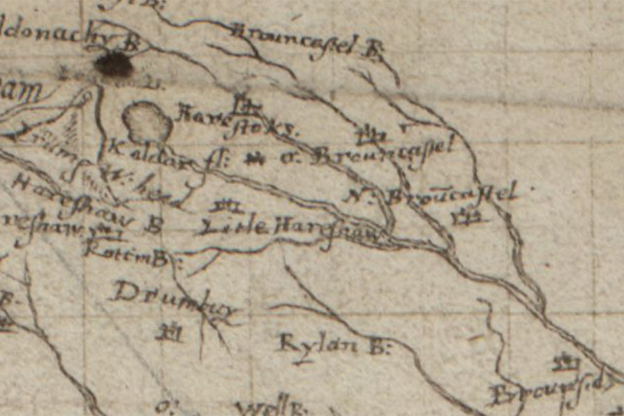
In 1513 William Cunningham received a sasine from the king for the half merk lands of Brouncastell, but little seems to have been written about them in the following century. Nether Browncastle is marked on Pont’s late 16th century map as a tower named N. Brouncastel.

Nether Browncastle

Glasgow and the county of Lanark
Timothy Pont, c. 1583 – 1596map image courtesy of NLS

James Blackadder of Tulliallan was granted the 8 shilling lands of Brouncastell in 1608, presumably the same lands that William Schaw of Polkemmet owned in 1501.

In 1621 William Cunningham of Cunninghamhead was retoured heir to his father, John Cunningham of Cunninghamhead, in the 6 shilling, 8 penny lands of Brouncastell which along with some other lands in the sheriffdom or Ayr were erected into the barony of Powkellie.

David Lindsay of Linbank released the feu and quitclaim of the 6 shilling, 8 penny lands of Eister Brouncastell in 1624 which may indicate that the lands had been rented out as in 1630 they were once again in Cunningham hands.

In that year William Cunningham of Cunninghamhead, his wife, Elizabeth Nicolson, and their son and heir, also William, received a confirmation of various lands including the superiority of the 6 shilling, 8 penny lands of Brouncastell. However in 1644 the king ratified a charter and infeftment of 1637 to Bryce Semple of Cathcart which included the six shilling, eight penny land of Easter Browncastle. Nether Browncastle is marked on Blaeu’s map of 1654, based on Pont’s earlier work, as a tower named N. Brouncastel.

Browncastle featured in a legal dispute in Edinburgh in 1656 between Helen Hamilton, the daughter and heir of the late John Hamilton of Browncastle, a merchant burgess of Edinburgh, and Alexander Wardlaw, also a merchant burgess of Edinburgh. When John died he seems to have been in debt to Wardlaw and those debts defaulted on Helen, and Wardlaw applied to have the property Helen had inherited impounded until the debts were settled. You can read more on the dispute here. The property mentioned included:

half of that 18s. land of old extent called the Nethertoune of Brounecastell, pertinents, &c., thereof, which are parts of the 4-merk land of old extent of Brounecastell, in the barony of Kilbryd and sheriffdom of Lanark, also the rest of the said 4-merk land of Brounecastell called the Overtoune of Brounecastell, extending to 35s. 4d. land of old extent or thereby, pertinents, &c., thereof, and those two portions of land in the Overtoune of Brouncastell, sometime possessed by umquhile James Mathem and umquhile John Craige, and now by John Brounerig and Gawin Allansone, extending to 22s. 8d. land or thereby, with pertinents, &c., thereof, and that in warrandice and security of the said 18s. land of old extent called the Nethertoune of Brouncastell

This would suggest that the majority part of Browncastle, the 4 merk land, had been further subdivided into the Overtoune of Brounecastell, worth 35 shillings and 8 pence, and the Nethertoune of Brounecastell, worth 18 shillings, distinct from the 6 shilling, 8 penny lands of Easter or Nether Browncastle.

Helen seems to have settled her father’s debts as Browncastle remained in the Hamilton family, passing to the Hamilton of Dalzell family in the 18th century. The ownership of Nether Browncastle over the following two centuries is not clear however.

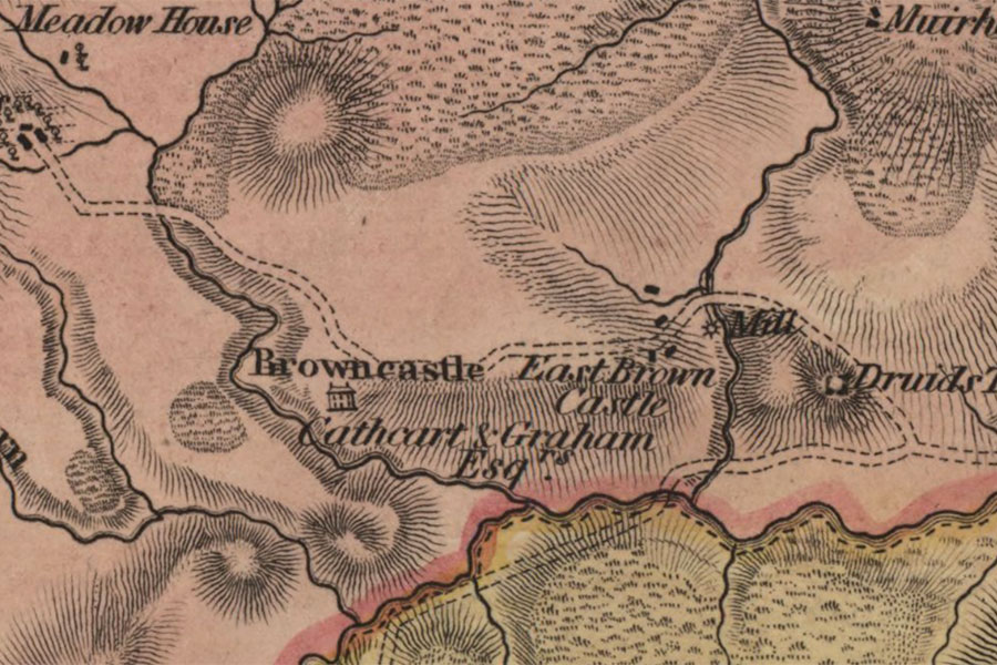
Forrest’s map of 1816 shows a few scattered buildings named East Brown Castle and a substantial mansion at Browncastle.

Nether Browncastle

The county of Lanark from actual survey
William Forrest, Edinburgh, 1816map image courtesy of NLS

East Browncastle isn’t marked on Ainslie’s map of 1820 but is shown as a couple of small buildings named E. Brown Castle on Thomson’s map of 1832. East Browncastle is again notable by its absence on Knox’s map of 1836. Johnson’s map of 1841 seems to be based on Thomson’s map of 1832 and as such shows a couple of small buildings marked as E. Brown Castle.

Browncastle

Lanarkshire XXIX.4 (East Kilbride)
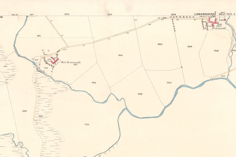
Ordnance Survey, 1859image courtesy of NLS

By 1861 both East Browncastle and West Browncastle were owned by Robert Steele, “commonly called Provost Steele”. Robert’s father had attended the laird of Browncastle’s horses, a job which Robert subsequently took on. Robert went on to be Provost of Rutherglen between 1837 and 1846, and again between 1852 and 1855, and bought both Browncastles. Provost Steele doesn’t seem to have resided at either of the Browncastle farms which were both tenanted, with the farmhouse of East Browncastle occupied at that time by James Pate. I haven’t been able to trace their subsequent ownership.

East Browncastle farm was redeveloped in the early 21st century with old farm buildings converted into residential properties and new houses built. The former farmhouse appears to be Victorian in proportions and style.

stay in a castle
  • advertisement
  • advertisement

Alternative names for Nether Browncastle

Brouncastell; Brounecastell; East Brown Castle; East Browncastle; Easter Browncastle; Eister Brouncastell; Eisterbrouncastell; Estir Brouncastell; N. Brouncastel; Nether Brouncastel; Nether Brouncastell; Nether Brounecastell; Nether Browncastle

Surnames associated with Nether Browncastle

Cunningham

Hamilton

Lindsay

Where is Nether Browncastle?

Nether Browncastle is in the parish of East Kilbride and the county of Lanarkshire.

Grid reference:NS 63130 43332

Lat / long:55.66416,-4.17741

Bing Maps | Google Maps | Historic maps (NLS) | OpenStreetMap | Ordnance Survey | PastMap | Streetmap | Wikimapia

OS Map for Nether Browncastle

OS map 334
East Kilbride, Galston & Darvel (Loudoun Hill & Whitelee Forest)
OS Explorer map 334


  • advertisement

Directions to Nether Browncastle

Enter a starting point

  • advertisement

Weather at Nether Browncastle

9°C
max 9°C / min 8°C
12km/h SE
1004mb
93%
100%
06:20 18:28

Light rain
Weather observed at Strathaven at 22:50

References (books)

Inquisitionum ad Capellam Domini Regis Retornatorum quae in publicis archivis Scotiae (Volume 1)
Various
London, 1811
Munimenta Alme Universitatis Glasguensis, Volume 1
Various
Glasgow, 1854
The Castles of Scotland
Martin Coventry
Prestongrange, 2015
The Commissariot Record of Hamilton and Campsie - Register of Testaments 1564-1800
Francis J. Grant
Edinburgh, 1898
The Exchequer rolls of Scotland (Volume 14)
George Burnett
Edinburgh, 1893
The Register of the Great Seal of Scotland A.D. 1424-1513
James Balfour Paul
Edinburgh, 1882
The Register of the Great Seal of Scotland A.D. 1513-1546
James Balfour Paul
Edinburgh, 1883
The Register of the Great Seal of Scotland A.D. 1593-1608
John Maitland Thomson
Edinburgh, 1890
The Register of the Great Seal of Scotland A.D. 1620-1633
John Maitland Thomson
Edinburgh, 1894
The Register of the Great Seal of Scotland A.D. 1652-1659
John Maitland Thomson
Edinburgh, 1904
The Register of the Privy Seal of Scotland (Volume I)
Matthew Livingstone
Edinburgh, 1908

References (websites)

Canmore

Castles near Nether Browncastle

Browncastle (site of)

0.9km away

Peelhill (possible) (site of)

6.7km away

Strathaven Castle

7.3km away

Tower of Udstonhead

8.1km away

Polnoon Castle

9.2km away

Lickprivick motte

9.3km away

The Tor

9.5km away

Lickprivick Castle

9.5km away

Silvertonhill (site of)

9.6km away
more castles....

Ancient sites near Nether Browncastle

Gowkstone standing stone

14.4km away

Camp Castle broch

22.9km away

Gleniffer Braes standing stones

24.5km away

Drybridge cursus

27.9km away

Kirk Hill (possible) fort

31.3km away

Shirva (site of) souterrain

32.7km away

Craigmaddie Muir (possible) standing stones

33.3km away

Craigmaddie Muir cairn, standing stone

33.4km away

Law Stone of Mugdock (site of) standing stones

34.0km away
more ancient sites....
  • advertisement

Pictish stones near Nether Browncastle

Hawkhill Class III cross-slab

56.2km away

Old Kilmadock 2 Class I symbol stone

59.6km away

Old Kilmadock 1 Class II symbol stone

59.6km away

Princes Street Gardens Class I symbol stone

68.9km away

Abernethy No. 2 Class III symbol stone

69.5km away

Abernethy No. 4 Class III cross shaft

69.5km away

Tullibole Class III cross slab

71.4km away

Blackford Class I symbol stone

72.7km away

Borthwick Mains Class I symbol stone

85.3km away
more Pictish stones....
  • advertisement

Pictish sites near Nether Browncastle

Whitecleugh silver chain

29.5km away

Todholes (possible) silver chain

40.7km away

Borland silver chain

43.0km away

Whitlaw silver chain

86.6km away

Haddington silver chain

93.4km away

Traprain Law silver chain

100.4km away

Norrie's Law hoard

101.0km away

Hoardweel silver chain

116.8km away

Dunnicaer fort

189.7km away
more Pictish sites....
  • advertisement

Accommodation near Nether Browncastle

Best Western Strathaven Hotel
hotel, restaurant, barStrathaven
8.0km away
Macdonald Crutherland House
hotel, restaurant, barEast Kilbride
8.6km away
Premier Inn Glasgow East Kilbride Central
hotel, restaurantEast Kilbride
10.3km away
Best Western Eglinton Arms Hotel
hotel, restaurant, barEaglesham
10.4km away
The Bruce Hotel, East Kilbride
hotelEast Kilbride
10.8km away
Premier Inn Glasgow East Kilbride (Peel Park)
hotel, restaurantEast Kilbride
11.2km away
The Torrance Hotel
hotel, bar, restaurantEast Kilbride
11.5km away
Premier Inn Glasgow East Kilbride (Nerston Toll)
hotel, restaurantEast Kilbride
12.2km away
Holiday Inn Glasgow East Kilbride
hotel, bar, restaurantEast Kilbride
12.4km away
Crossbasket Castle
hotel, restaurantHigh Blantyre
13.6km away

Accommodation search

(leave blank to view all)
Accommodation type
bed and breakfasts
campsites
castles
holiday parks
hostels
hotels
self-catering apartments
self-catering cottages
self-catering lodges
spas
  • advertisement
more accommodation....

Cafés, restaurants & bars near Nether Browncastle

Best Western Strathaven Hotel
hotel, restaurant, barStrathaven
8.0km away
Macdonald Crutherland House
hotel, restaurant, barEast Kilbride
8.6km away
Premier Inn Glasgow East Kilbride Central
hotel, restaurantEast Kilbride
10.3km away
Best Western Eglinton Arms Hotel
hotel, restaurant, barEaglesham
10.4km away
Premier Inn Glasgow East Kilbride (Peel Park)
hotel, restaurantEast Kilbride
11.2km away
The Torrance Hotel
hotel, bar, restaurantEast Kilbride
11.5km away
Premier Inn Glasgow East Kilbride (Nerston Toll)
hotel, restaurantEast Kilbride
12.2km away
Holiday Inn Glasgow East Kilbride
hotel, bar, restaurantEast Kilbride
12.4km away
Crossbasket Castle
hotel, restaurantHigh Blantyre
13.6km away
Busby Hotel
hotel, bar, restaurantBusby
14.1km away
more food.... / more drink....

Related pages

Dirleton Castle in East Lothian
Garden of Cosmic Speculation plus castles
Inveraray Castle and standing stone
A doocot, a castle and a beach in East Lothian
A pair of castles on the River Tweed
Dunbar harbour and castle
Published on the 20th of December 2020 at 7:09 pm. Updated on the 29th of December 2020 at 5:23 pm.

Leave a comment

back to the top of the page

Connect with us

Like us on Facebook

Receive our newsletter

Follow us on Twitter

Tweets by Stravaig_Aboot
  • advertisement

Quick links

Stay in a Scottish castle
Edinburgh Festival accommodation
Hotels in Scotland
Car hire in Scotland
Places to eat and drink in Scotland
Castles in Scotland
Trace your Scottish ancestors
Scottish clans
Standing stones in Scotland
The Picts
Pictish symbol stones
Pictish placenames
Scottish bands and musicians
Scottish films
Scottish TV shows
West Highland Way

About

Andy Sweet above Fast Castle

Stravaiging around Scotland is written, photographed and researched by Andy Sweet.
read more....

Cookies

To make this site work properly we use cookies to store information on your computer. Click here to read more.
© 2003 - 2023 Andy Sweet / Stravaiging around Scotland. Powered by WordPress. Hosted by Tsohost.