Sandness
Alternative names for Sandness
Sandness, St Margaret's Kirk; Sandness Church
Where is Sandness?
Sandness is in the parish of Walls and Sandness and the county of Shetland.
Grid reference: HU 1912 5765
Lat / long: 60.3026472541303, -1.65437291185725

OS Map for Sandness
Directions to Sandness
Enter a starting point
Get directions

Weather at Sandness
5°C
max 5°C / min 5°C
max 5°C / min 5°C
26km/h NNW
1019mb
67%
8%
04:21 19:47
1019mb
67%
8%
04:21 19:47
Clear sky
Weather observed at Shetland Islands at 06:36
References (books)
References (websites)
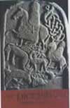
Pictish stones near Sandness
Pictish sites near Sandness
Pictish placenames near Sandness
Ancient sites near Sandness
Castles near Sandness


Accommodation near Sandness
Hurdiback Backpackers Hostel
3.0km away
St Magnus Bay Hotel
21.7km away
Lerwick SYHA Hostel
32.4km away
Kveldsro House Hotel
33.0km away
Saxa Vord Hostel
71.8km away
Papay Youth Hostel
126.3km away
Ayre's Rock Hostel (Sanday SYHA Hostel)
127.6km away
Eday SYHA Hostel
134.5km away
Birsay SYHA Hostel
159.3km away
Merkister Hotel
163.8km away
Accommodation search
Cafés, restaurants & bars near Sandness
Kveldsro House Hotel
33.0km away
Saxa Vord Hostel
71.8km away
The Storehouse
200.3km away
Holborn Hotel
216.0km away
Red Pepper Restaurant
216.0km away
Royal Hotel Thurso
216.1km away
Ackergill Tower
218.5km away
Rockpool Café
297.4km away
Royal Golf Hotel
299.4km away
The Eagle
299.5km away


