Thirlestane Castle
Thirlestane Castle has been home to the Maitland family for hundreds of years, however the early origins of the castle are unclear.
The Maitlands had previously lived at what is now known as Old Thirlestane Castle, some 2 miles (3km) to the east, from the 13th century onwards, which at the time was known as Thirlestane Castle.
In 1586 John Maitland was appointed Lord Chancellor of Scotland, and the following year, probably connected in some way to his new status, he bought the lands of Castlehill from Alison Cranstoun and her husband George Wedderhede.
The site had been occupied by an artillery fort built by the English in 1548 during the Rough Wooing. In 1550 it was besieged by the Scots, and surrendered under a peace treaty signed on the 10th of April that year, eventually ending up in the possession of the Cranstouns.
Maitland set about building a new castle, consisting of a large rectangular block running approximately south-west to north-east and measuring some 33.0m long by 6.7m wide. Interestingly however, when visiting the castle and passing between the rooms on the ground floor, it seems that the south-western end of the castle may have earlier origins, as the walls between rooms there seem considerably thicker (up to 4.0m) than those further back towards the north-eastern end.
Which makes it tempting to suggest that Thirlestane Castle initially consisted of a shorter rectangular tower around half the length of the later tower. Whether or not this is the case I have not been able to discover as yet.
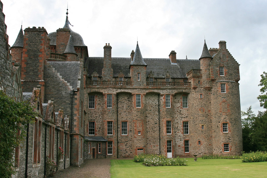
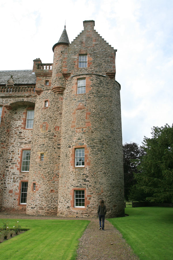
At each of the four corners of the main rectangular block was a large round drum tower, and in the angles between the round towers and the longer north and south sides of the main keep are small spiral staircases. Also arranged along the longer north and south walls are three smaller semi-circular tower projections, three on each side.
In 1590 John Maitland was created Lord Maitland of Thirlestane by James VI, but died five years later in 1595, and was succeeded by his son, also named John. The 2nd Lord Maitland of Thirlestane doesn’t seem to have made any significant additions to Thirlestane Castle, but continued the family’s upwards social trajectory and was made Viscount of Lauderdale in 1616, then 1st Earl of Lauderdale, Viscount Maitland, and Lord Thirlestane and Boltoun in 1624. It was he who was responsible for naming his father’s new castle Thirlestane Castle.
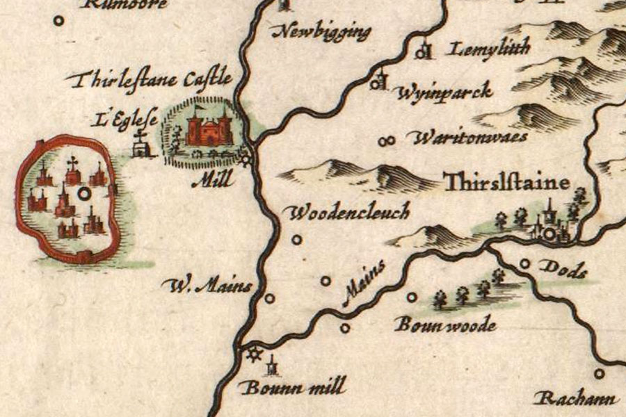
Old Thirlestane Castle was seemingly still in use at this time, as it is still shown as a substantial castle, named Thirslstaine, in Joan Blaeu’s Atlas of Scotland, which was published in 1654 but based partly on Timothy Pont’s maps from the late 16th to early 17th century, while the Maitlands’ new home is named Thirlestane Castle.
Upon his death in 1645, he was succeeded by his son, another John, who would later become Secretary of State for Scotland, and in 1672 would be created the 1st Duke of Lauderdale.
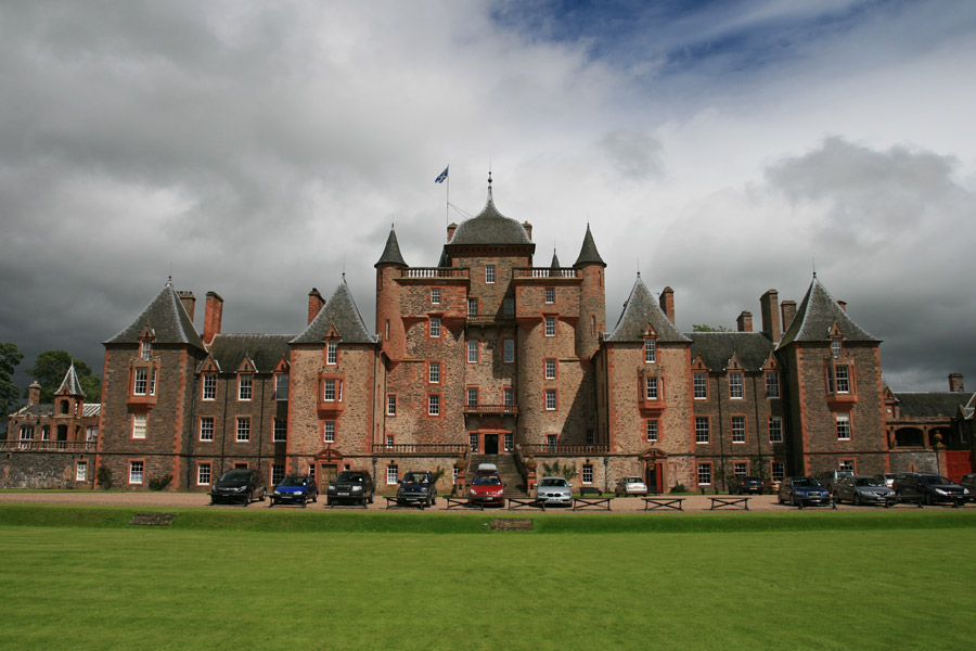
In 1670 this John Maitland commissioned Sir William Bruce to turn Thirlestane Castle into a luxurious palace, apparently diverting workmen and materials from the Palace of Holyroodhouse. The interiors were completely transformed into lavish rooms suitable for entertaining distinguished guests, while the outside also underwent significant changes.
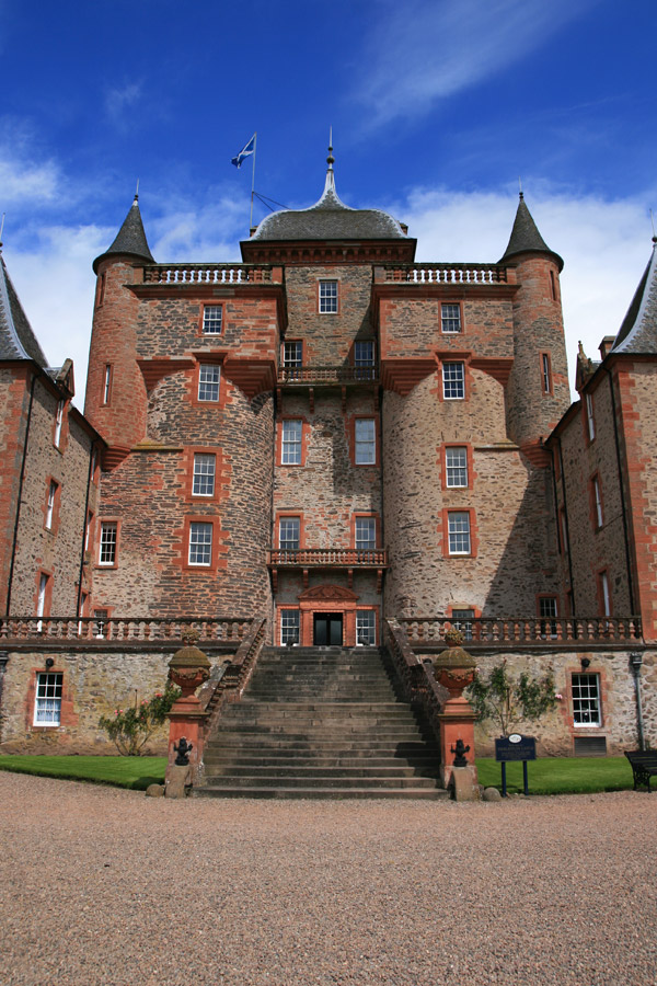
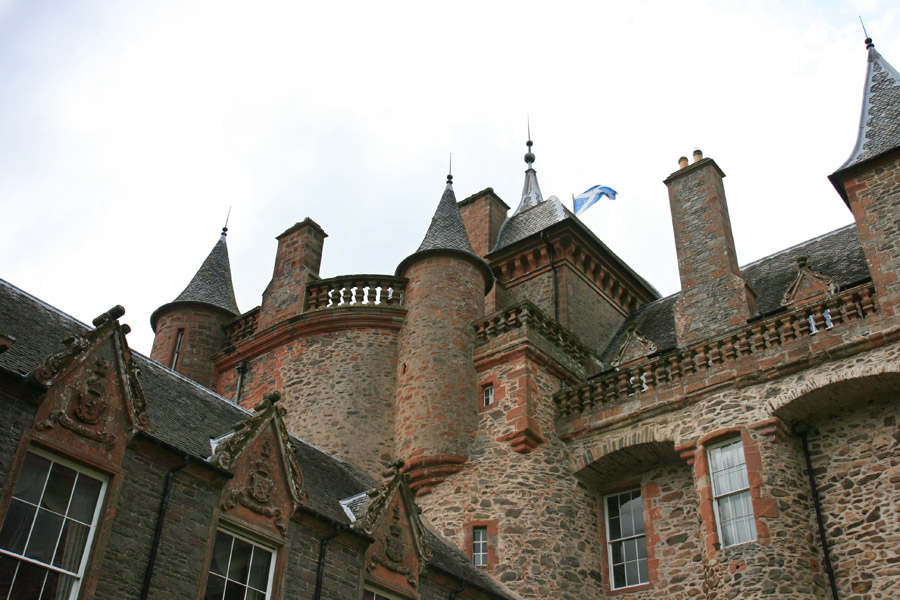
The façade was changed considerably, with a grand staircase leading up from a lower courtyard onto a new terraced area on what was originally the castle mound. The drum towers were flattened on their outer edges as they join up with new rectangular wings flanking the terrace, three storeys in height at terrace level, with a fourth storey below at courtyard level.
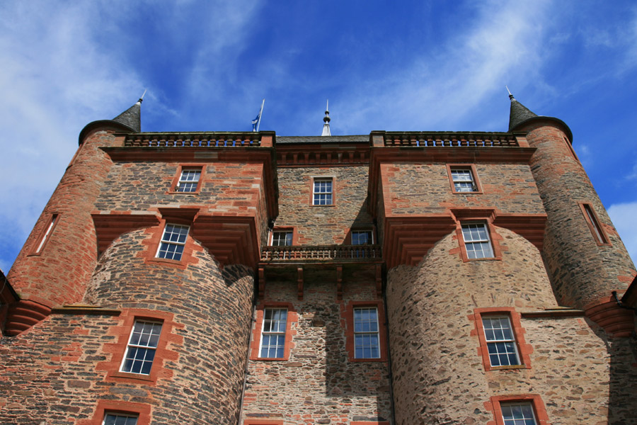
Bruce added a large Greek-inspired pediment at the top of the central block, although this was replaced in the 19th century when the central block was extended upwards by David Bryce and William Burn in the 19th century, creating a taller central tower with ogee roof at this end of the building.
The corbelled-out square caphouse-like structures on the top of the rounded towers were also added by Bryce and Burn.
Once up onto the terraced area at the top of the new stairs, the ornately-carved pink sandstone doorway surround is seen in detail, with carved columns and pediment.
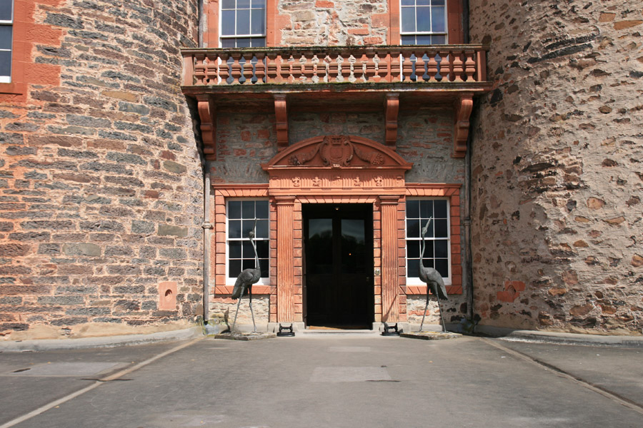
Both immediately above the door and further up between the new square additions Bryce and Burn added balconies, clearly inspired by the balconies that Bruce had added to the sides of the castle almost two centuries earlier, more of which later.
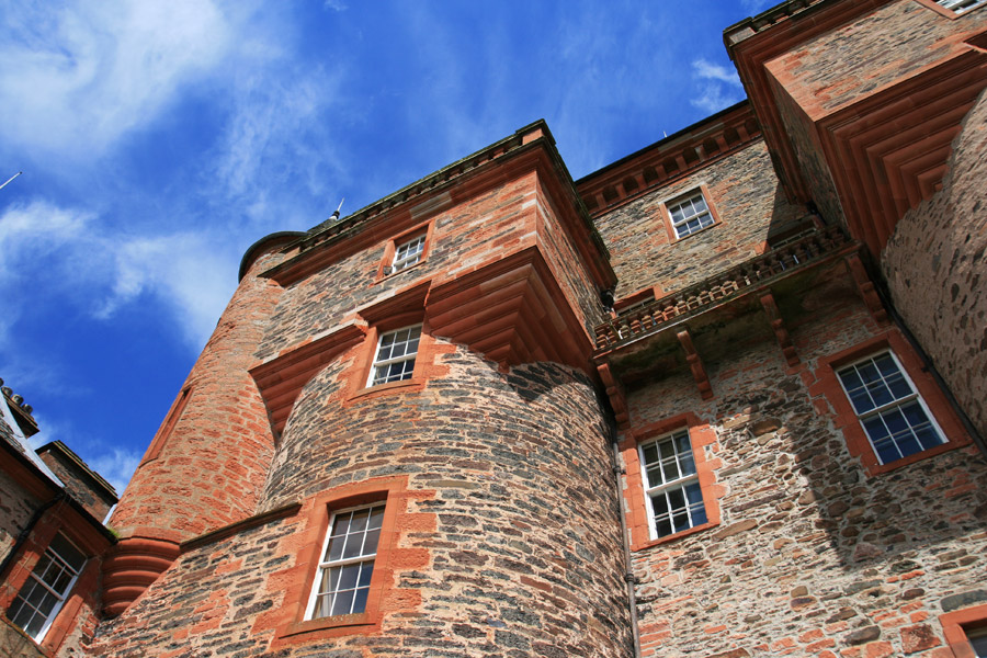
Along the sides of the main block Bruce inserted numerous large windows into the original walls and towers, and added an arched balcony running between the tops of the semi-circular towers.
According to drawings done by John Slezer around 1690, Bruce also added three storey rectangular towers at the rear of the castle, mirroring those at the front, joined by a low block containing bedrooms. However these have been removed at some point in history, restoring the rear of the castle to something approaching its original form, albeit with Bryce and Burn square caphouses on top of the drum towers.
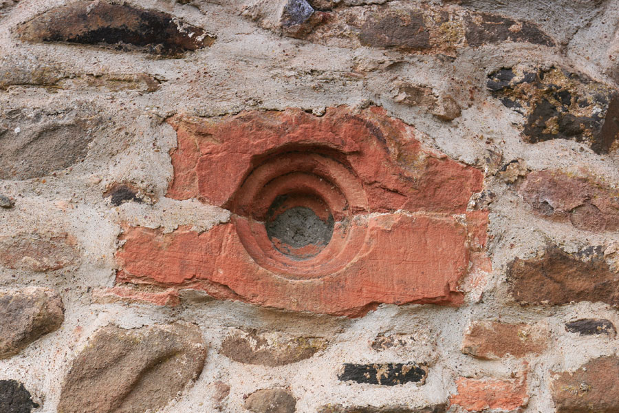
Along the bottom of the north and south walls of the main block are a series of filled-in gun loops, pointing to the castle’s original defensive purpose prior to its later transformation into a grand mansion house.
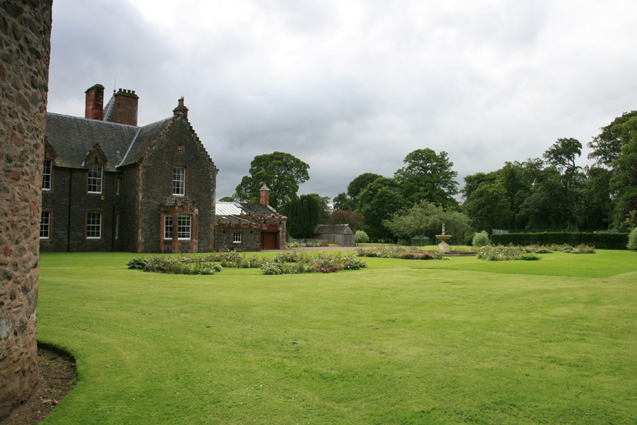
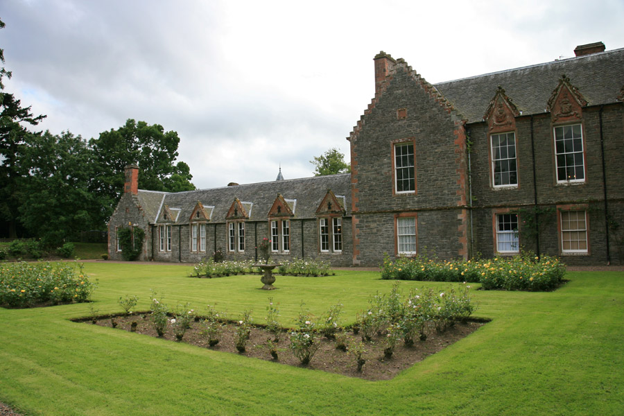
Bruce also added low, one storey wings to either side of the front of the castle, which presumably contained estate offices, stables and the like. Behind these wings, ornamental gardens were laid out.
Interestingly Thirlestane Castle is still referred to as The Fort on Herman Moll’s map of The Shire of Berwick, drawn some time before 1732 and published in 1745, while Old Thirlestane Castle appears as Thirlstain. This was possibly just a way of distinguishing the two Thirlestane Castles from one another, or perhaps the new Thirlestane Castle was still known colloquially by its old name.

On William Roy’s Military Survey of the Lowlands, published between 1752 and 1755, Thirlestane Castle is marked as Lauder Castle, while Old Thirlestane Castle is shown as a group of five buildings, perhaps suggesting that it was still in use and noteworthy.
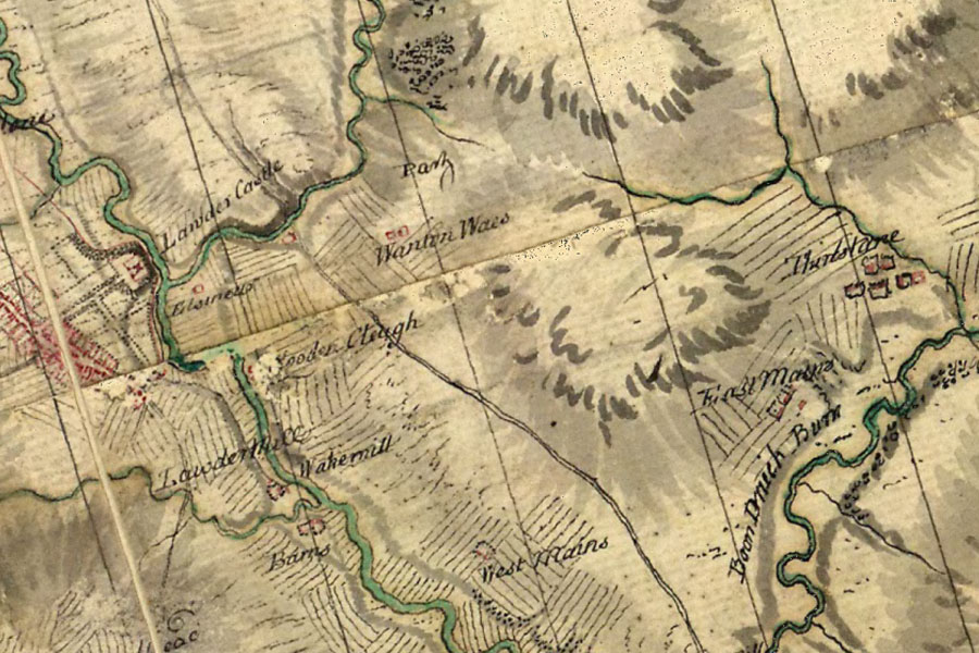
Armstrong’s Map of the County of Berwick, published in 1771, shows Old Thirlestane Castle as Thirlstane and marked as in ruins, while the new Thirlestane Castle is also now called Thirlstane, indicating perhaps that Old Thirlestane Castle didn’t completely fall out of use until some time in the mid-18th century.
As previously alluded to, in 1840 David Bryce and William Burn were commissioned, presumably by Thomas Maitland, the 11th Earl of Lauderdale, to extend and remodel Thirlestane Castle. They added three storey wings to the north and south of the front, with their flanking towers echoing the style of those added by Bruce.
Beyond these wings were further low wings containing the kitchen, pantry, laundry and servants’ accommodation, behind which were gardens, seemingly on the same general plan as those laid out by Bruce.
Bryce and Burn were responsible for giving Thirlestane Castle its distinctive roofline, combining original features with those added by Bruce, and blending it with their own signature Scottish Baronial revival style.
Thirlestane Castle remained in the Maitland family throughout the 19th and 20th centuries, and was extensively restored and repaired by them during the 1970s and 1980s. In 1984 the castle was gifted to the Thirlestane Castle Trust by Captain Gerald Maitland-Carew, the 18th Earl of Lauderdale. The Maitland family now live in the north wing, and the castle is open to the public.


Alternative names for Thirlestane Castle
Lauder Castle; Lauder House; Lauder Fort; The Fort; Thirlstane
Where is Thirlestane Castle?
Thirlestane Castle is in the parish of Lauder and the county of Berwickshire.
Grid reference:NT 53385 47902
Lat / long:55.72228,-2.7436594