Strathbrock Castle
Strathbrock Castle was a 12th century castle built by Freskin however nothing of it now remains in situ.
The lands of Strathbrock were granted to Freskin, a Flemish nobleman, by David I in the 12th century. It is likely that he constructed a castle on a motte on the site which lies on what was a main route between Glasgow and Edinburgh and occupies a position above the Brox Burn. A small conical knowe was apparently still to be seen at the site in the 19th century and may have been the remains of the motte.
In the mid-12th century, some time between 1166 and 1171, the ownership of the lands of Strathbrock, Roseisle, Inchkeil, Duffus, Kintrae and Machar was confirmed by William the Lion to Freskin’s son, William. Dame Katharine Stewart, Lady Cardross, apparently had in her possession the original charter in the 18th century but more of her later.
William was succeeded by his eldest son, Hugh, who assumed the surname Moravia. Simon of Strathbrock is mentioned in a charter of 1225 and an Archibald of Strathbrock was witness to a charter of 1229. A Mary de Moravia, said in some sources to be Freskin’s eldest daughter although this seems unlikely due to the dates, married Sir Reginald le Chene or Cheyne of Inverugie, son of Sir Reginald Cheyne who was Chamberlain of Scotland between 1267 and 1269.
In 1287 the younger Reginald entered into a an agreement with William of Fedderate, ‘portionary’ of Duffus, and his wife Christiana, regarding land in Duffus and Strathbrock.
Some time between 1264 and 1292 Reginald granted the monks of Newbattle Abbey free transit across the lands of Strathbrock while on their way between the abbey and their lands in the Clyde valley. Reginald died in 1293 and the lands passed to his son, also Reginald Cheyne, who died in 1312 and was succeeded by his son, another Sir Reginald. In 1323 Robert the Bruce granted, or perhaps reconfirmed, the lands of Strathbrock to this Sir Reginald.
When Sir Reginald died without a male heir, variously recorded as in 1345 or 1350, his possessions passed to his daughters, Mary and Mariota. It was Mariota who received the barony of Strathbrock and in 1366 she gave half of the barony to her son, James, from her marriage to John Douglas, Strathbrock passing into the Douglas family at this time. Later she married Sir John Keith of Ravenscraig, second son of Sir Edward Keith, Marischal of Scotland, and in 1390 she gave the remaining half of the barony, known as Kirkhill, to her son. Andrew, from that marriage.
This split in the barony of Strathbrock seems to have caused some confusion regarding ownership over the centuries, with Strathbrock seemingly being used as the name for both the Strathbrock and Kirkhill parts. However Sir James Douglas of Strabrok is mentioned in a document of 1407 and in 1425 Strathbrock was owned by Sir William Douglas, whose daughter married George Crichton of Cairns, later 1st Earl of Caithness.
By 1443 Strathbrock was owned by William Douglas, 8th Earl of Douglas, and so the lands of Strathbrock were caught up in the battle between the Black Douglases and those controlling the infant James II. William Crichton, 1st Lord Crichton, who had declared himself Lord Chancellor, laid waste to the lands of Strathbrock in the same year while aided by James Douglas, 3rd Earl of Angus.
In 1455 James II annexed the Douglas lands to the Crown and in 1456 James Kennedy, Bishop of St Andrews, received from the King £55 13s 4d from “the fermes of the lands of Strathbrock, with the demesne lands easter and wester of the same” for keeping Edinburgh Castle. Later in the 15th century Colin Campbell, 1st Earl of Argyll, drew a £40 annual fee from Houston, West Mains, Strathbrock and Kirkhill, possibly while Lord High Chancellor (1483 to 1487).
By the late 15th century Strathbrock was in the possession of the Sutherlands of Duffus. This may have been due to the marriage between either the sister or daughter Andrew Keith of Inverugie and Strathbrock, the son of Mariota and Sir John Keith, and Kenneth Sutherland, third son of William, 5th Earl of Sutherland.
When Alexander Sutherland of Duffus died around 1484 his daughter and heir, Christian, succeeded however her legitimacy was questioned by the next in the male line and conflict broke out. A settlement was reached around 1507 with Christian relinquishing her claim to Duffus but keeping her lands at Berriedale in Caithness as well as Strathbrock. Since she had married William Oliphant, second son of Laurence, 1st Lord Oliphant, in 1489, Strathbrock passed to the Oliphant family.
In 1514 James IV granted to Sir Patrick Hamilton of Kincavil, an an illegitimate son of James Hamilton, 1st Lord Hamilton, 8 oxgangs of land in the barony of Strabrok, which once belonged to George Oliphant, William Oliphant’s son. The Oliphants continued to own land here however as in 1520 there was a sasine of half of the barony of Strabrok to Andrew Oliphant, cousin or nephew of Laurence Oliphant, 3rd Lord Oliphant.
Sir John Dingwall, archdeacon of Caithness and rector of the church of Strathbrock, was granted the principal mansion, orchard and garden of Wester Strabrok in 1524 by James V. Although the castle wasn’t explicitly mentioned, Strathbrock Castle does seem to have been the principal mansion at this time.
In 1526 Andrew Oliphant sold the lands of Strabrok, along with the lands of Berriedale and Auldwik, to the 3rd Lord Oliphant.
James V confirmed and granted numerous properties including the barony of Strabrok to William Keith, 4th Earl Marischal, and his wife, Margaret Keith, eldest daughter of William Keith of Inverugie in 1538. There was perhaps a familial connection here as the 3rd Lord Oliphant was the son of Lady Elizabeth Keith, second daughter of William Keith, 3rd Earl Marischal.
A sasine from 1581 confirms George Keith, 5th Earl Marischal, as the owner of “the half lands and barony of Strabrok”. However in 1614 various possessions of Sir William Oliphant of Newton, along with “all and whole the half lands and barony of Strathbrock” were erected into a free barony called Strathbrock-Oliphant.
In 1628 George Seton, 3rd Earl of Winton, received a charter of “half of the lands of Strabrok, united into the barony of Broxburn” but from whom I have not been able to establish. His eldest daughter, Elizabeth, married William Keith, 7th Earl Marischal, in 1637 so there may have been some connection here earlier.
Various Hamiltons are mentioned in the 17th century in connection with Strathbrock, perhaps descendants of Hamilton of Kincavil. Sir John Hamilton of Strabrock is mentioned in a “Taxt Roll” of 1630 and in 1632 Andrew Hamilton of Redhouse was granted the barony of Strabrok-Oliphant which formerly belonged to William Oliphant of Kirkhill.
In 1635 Sir John Hamilton of Redhouse was served heir to his father “in the equal half of the lands and barony of Strabrock, &e. all united into the barony of Strabrock-Oliphant”.
John Seton of Lathrisk received a charter from Charles I in 1638 of “the half of the lands of Strabrok” upon the resignation of William Keith, Earl Marischal. Whether this was the 6th or 7th Earl Marischal I have not been able to establish. Since the 6th Earl, son of the 5th Earl, died in 1635 it may have been the 7th Earl who was married to Elizabeth Seton.
In 1642 the lawyer Sir Lewis Stewart, a great-grandson of William Stewart of Rosyth, bought “the barony of Stratbroke and Kirkhill” and the two halves of the barony were seemingly reunited. Sir Lewis died in 1655 and was succeeded by his first son, Sir James Stewart, however he died in 1666 and was succeeded by his brother, Sir William.
Following the death without a male heir of Sir William Stewart of Strathbrock and Kirkhill in 1671 the estates went to their sister, Katharine or Catherine. She married Henry Erskine, 3rd Lord Cardross and the estates passed into that family. However Sir William had granted a “three 19 years tack” of some lands in Strathbrock to Alexander Hamilton, his bailie or factor, in 1671 and this led to a court case between Lady Cardross and Hamilton’s son, John Hamilton of Pumpherston in 1708, Lady Cardross being successful in her challenge.
David Erskine, 11th Earl of Buchan, wrote in 1781 an “Account of the Parish of Uphall” in which he stated that he had moved to Strathbrock in 1768 (the year after the death of his father, Henry Erskine, 10th Earl of Buchan) and lived at Kirkhill in the summer months. At the time of writing he stated that the “heritors who share this parish with me are Mr Shairp of Houston and Mr Barclay of Middleton.” In 1790 Erskine exchanged with his brother, Henry Erskine, “a portion of the entailed lands and barony of Strathbrock” for The West Croft of Kinpunt in Kirkliston. Henry Erskine’s son, also Henry Erskine, succeeded his uncle in 1829 in the lands of Strathbrock and as 12th Earl of Buchan.
Stratbrock Kirk is marked on Pont’s late 16th century map but it’s difficult to make out if the castle is marked separately. It is however marked on Hondius’ map of 1630 which is based on Pont’s work, and also appears on Blaeu’s map of 1654. The castle isn’t marked on later 17th or 18th century maps, suggesting perhaps it had fallen out of use, however “Site of Strathbrock Castle” is marked on the Ordnance Survey 25 inch map of 1856 to the south of Broadyates farm, sometimes referred to as Broadyetts.
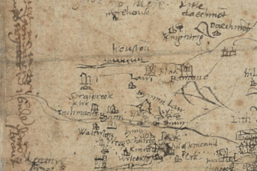
Timothy Pont, c. 1583 – 1596map image courtesy of NLS
From the later 17th century Houstoun House and Kirkhill seem to have been the principal residences of the old barony of Strathbrock, and the last remains of Strathbrock Castle were removed at the beginning of the 18th century (although some sources say around 1790). Some of the stone is said to have been reused in the rebuilding of Middleton Hall around 1707.
As with many other castles there was a legend regarding a long tunnel connecting Strathbrock Castle with Niddry Castle, however given the 5km distance between the two this seems highly unlikely.
In the 19th century the site of the castle was known as Castlehill, and before that Castlefield, and a property seems to have been built beside it since large heaps of oyster shells were uncovered “in the garden of Castlehill”. Broadyetts is supposed to refer to the location of the gateway into the castle while Stankards, around 500m to the south east of Broadyetts, was said to refer to fishponds associated with the castle.
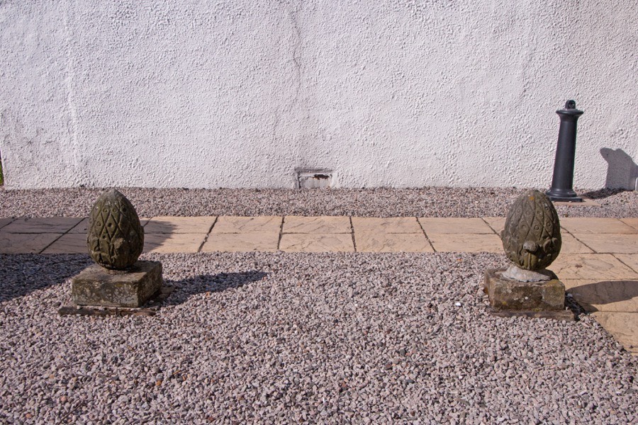
The foundations of a wall, said to be a castle wall, were discovered running north-west across Market Road, now Main Street, towards Broadyetts. Several carved stones were found within the grounds of Castlehill including the head of a cherub or child and two pineapple sculptures one of which was, in 1898, “lying in Houston Garden, the other place on the gable-top of Houston Mill”. The 11th Earl of Buchan described a date stone associated with the castle which “was said to bear the date 1158; but….I doubt the fact, as the centesimal figure is not legible.”
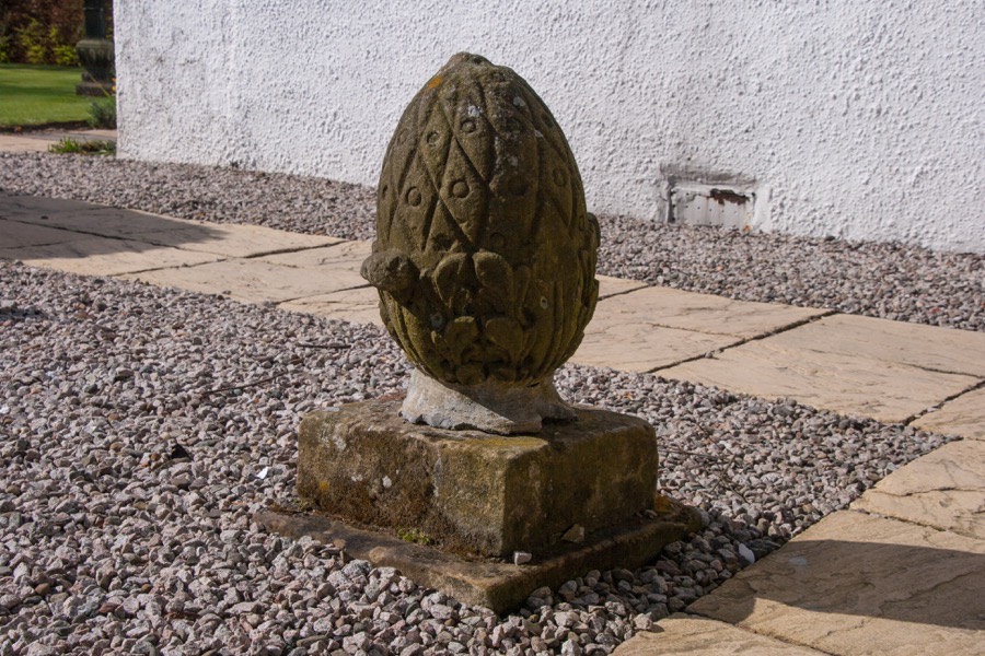
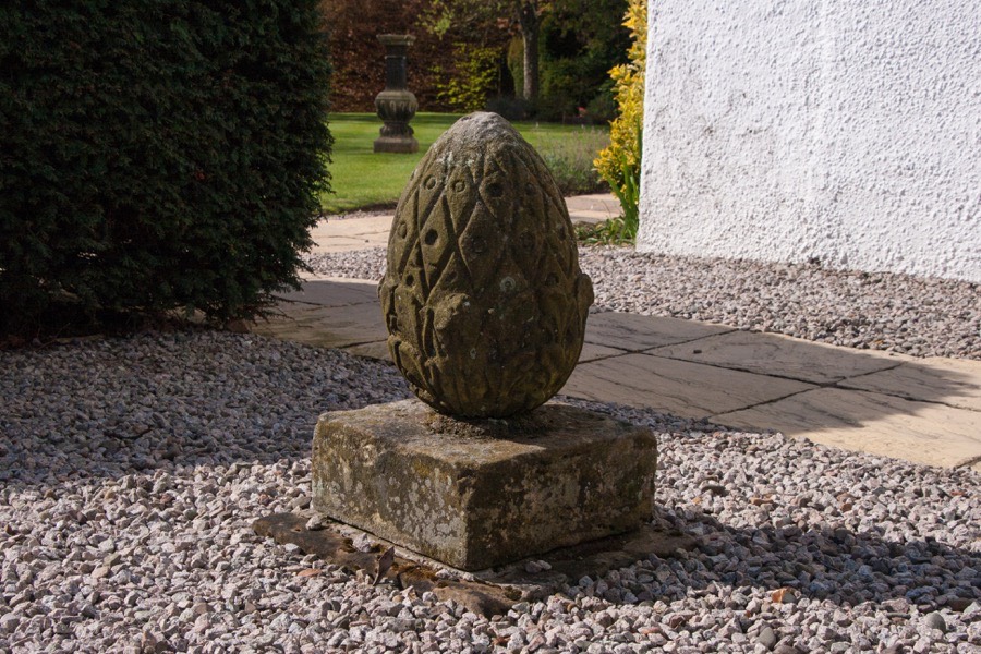
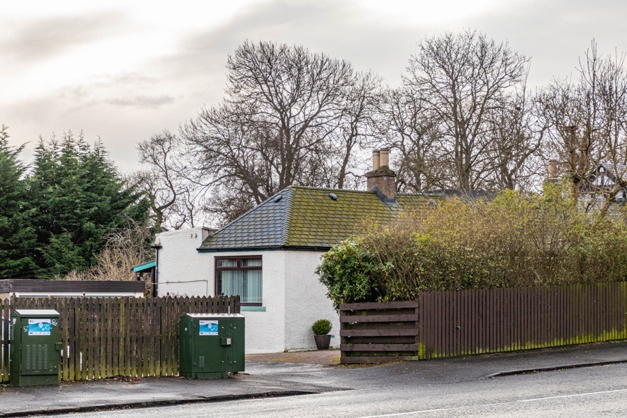
The pineapples, seemingly the only extant remains of Strathbrock Castle, now both stand within the grounds of Houstoun House. The old farm of Broadyetts has gone and the site is now occupied by a car dealership, while the site of the castle falls under a bungalow.


Alternative names for Strathbrock Castle
Castlehill; Strabork; Strabroc; Strabrock; Strabrocke; Strabrok; Strabroke Straebrok; Stratbrock; Stratbroke; Strathborke; Strathbroc; Strobrok; Uphall; Wester Strabrock; Wester Strathbrock; Westirstrabok