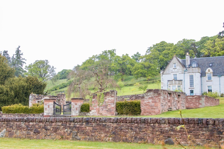
Stanley House
Stanley House is a ruined early 18th century mansion which may have been built around an earlier core.
The early history of Stanley House is not clear, not helped by the fact that it didn’t receive that name until the late 17th century. Some 19th century writers described it as having originally been built in the 15th century, at which time it would likely have been a defensible building given its prominent position on a promontory created by a bend in the River Tay. However this early origin may have been confused with that of the nearby Inchbervis Castle.
Inchbervis was once known as Incheturfin, a property of the church of the Holy Trinity of Dunkeld in the 12th century. The name is thought to mean the island or perhaps headland of Torfin, a Scandinavian personal name. It is possible that the lands of Incheturfin included those on which Stanley House now stands.
The lands of Incheturfin may have been held by Robert de Oghtergeven or Robert of Auchtergaven in the 13th century when the promontory is likely to have been fortified. He is on record in 1296 performing fealty to Edward I of England.
Little is written about the castle of Incheturfin until the 16th century when George Durie, the abbot of Dunfermline, granted the lands, named in the document as Inchetrewie, to John Ross of Craigie and his wife, Matilda Moncrieff, in 1539.
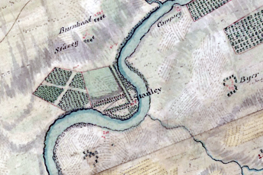
The castle of Inchtreuy is marked on two different Pont maps, published in the late 16th century. On a map of the area of Auchtergaven and Kinclaven it is drawn as a pair of towers joined by a wall or lower block through which is an arched gateway. The left tower seems to be four or five storeys in height with crenellated battlements while the right tower is three or four storeys in height with a pitched roof.
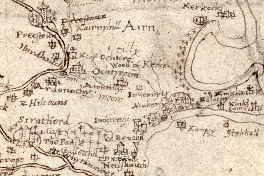
Timothy Pont, c.1583-96map image courtesy of NLS
On a map of Lower Strath Tay from Dunkeld to Benchil which partly covers the same area it is marked as Inchtyruy and drawn as a large four or five storey tower with crenellations.
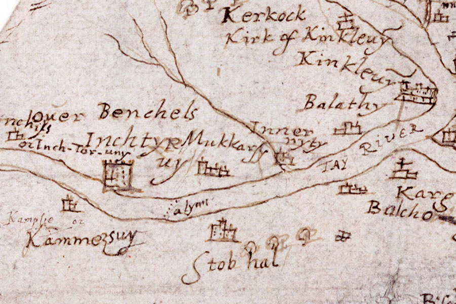
Timothy Pont, c.1583-96map image courtesy of NLS
If Stanley House had been built in the 15th century then it would be expected for it to be marked on the maps and for it to appear in early records however it doesn’t seem to, although its original name isn’t known. It’s possible that if Stanley House was constructed as a replacement for the old castle of Inchbervis then it might have gone by the same name although this is supposition.
The property seems to have remained in the hands of the Ross family into the 17th century as on the 9th of March 1605 Robert Ross received a charter of the lands of Inchstravie, while a charter dated the 5th of December 1606 confirms John Ross as owning the lands of Inchstrevie.
In April 1605 Thomas Nairne of Muckersie, a neighbouring property to Inchbervis, bought the lands of Mains of Auchtergaven from Christina Ross, the daughter and co-heiress of John Ross.
Some sources state that Stanley House was once known as Nairne House and later replaced the Mains of Auchtergaven as the seat of the barony of Auchtergaven however it would appear that Stanley House has been confused with the Nairne House at Loak, formerly known as Strathord Castle.
Thomas was succeeded by his son, Robert Nairne, an advocate, who by 1627 was in possession of the lands of Inchbervis. He married Catherine Preston, daughter of Sir John Preston of Penicuik, and was succeeded in 1652 by their son, another Robert and also an advocate.
In 1681 the younger Robert was knighted, appointed a Lord of Session and created 1st Lord Nairne. He was married to Margaret Graham, daughter of Patrick Graham of Inchbrakie, and they had one surviving child, also Margaret. The younger Margaret was married, at the age of ten, to Lord William Murray, fourth son of John Murray, 1st Marquess of Atholl, and Lady Amelia Sophia Stanley, fourth daughter of James Stanley, 7th Earl of Derby, and the younger brother of John Murray, 1st Duke of Atholl. The couple are said to have lived at Stanley House.
When the 1st Lord Nairne died in 1683 he was succeeded by his son-in-law, Lord Murray, as 2nd Lord Nairne. Stanley House was apparently given its name in the same year in honour of his mother-in-law.
Lord Nairne took part in the Jacobite Rising of 1715 with his son, John, but they were captured at Preston and sent to the Tower of London. The following year they were sentenced to death for treason but were reprieved in 1717, although their titles remained fofeited. In February 1726 Lord Nairne died and was succeeded by John as the de jure 3rd Lord Nairne.
In 1737 or 1738 John obtained an Act of Parliament which enabled him to inherit property, and this may have prompted further building work at Stanley House. A stone carved with the initials L.I.N., presumably for Lord John Nairne, and the date 16th June 1742 can be found in the garden.
Lord Nairne was a commander in the Jacobite Rising of 1745 and is said to have been at home at Stanley when he was warned that Government troops were approaching. He is reputed to have grabbed various important papers, forded the river and made his escape to Pitlochry. The room he fled from was identified as the dining room in 1883. Lord Nairne fought at the Battle of Culloden in April 1746 and was attainted as a result, fleeing to France. His estates were bought by his cousin, James Murray, 2nd Duke of Atholl.
William Roy, 1747-1752map image courtesy of NLS
In the spring of 1765 John Murray, 3rd Duke of Atholl, remodelled and extended “the House of Stanly” as a dower house for his mother, Amelia, wife of Lord George Murray and daughter of James Murray of Strowan and Glencarse. Lady Amelia died in 1766.
Later John Murray, 4th Duke of Atholl, leased Stanley House to his uncle, Captain George Murray of the Royal Navy, taking up residence in the autumn of 1784 following his marriage to the Hon. Wilhelmina King, daughter of the 5th Lord King.
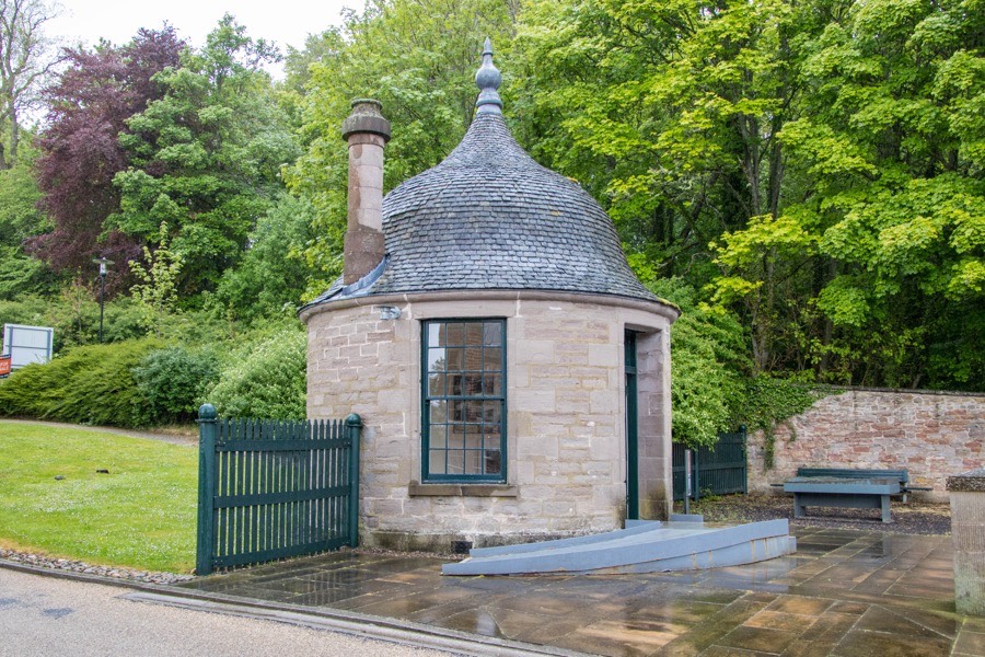
In 1785 George Dempster & Co feued land from the Duke of Atholl to build a mill, and when Stanley Mills was built the original approach to Stanley House was altered, leaving the Yett House or gatehouse isolated beside the mill buildings. Its form may give some clue as to the style of Stanley House in that period.
In November of that year Captain Murray signed a 21 year lease of Stanley House with his nephew, at a cost of £52, 10s. per annum, and also rented the Middle Stanley Fishings. Captain Murray had apparently already spent £1200 improving the estate and so the Duke “agreed to a sliding scale of repayment in the event of his uncle having to give up the place before termination of his lease.” Given the scale of his investment it may have been Captain Murray who was responsible for constructing a large walled garden to the north-west of the house.
Captain Murray was appointed captain of HMS Vengeance in September 1792 and as a result gave up his lease of Stanley House, and “in accordance with the table of calculations agreed to on his entry to the lease, the Duke repaid him £914 of the money he had laid out on the place”.
The East Mill at Stanley burned down in 1799 which led to the financial collapse of George Dempster & Co. In 1801 the Duke “feued the house, gardens and 65 Scots acres of land at Stanley” to James Craig for £228 per annum. However by 1814 Craig’s company was also in financial trouble and the mills fell silent until 1823 when Dennistoun, Buchanan & Co. took possession and spent £160,000 on their improvement.
In the 1830s Stanley House was substantially rebuilt, possibly for one of the company’s directors, George Buchanan of Stanley, when it underwent “a thorough repair, and received some additions” making it “doubtless one of the most comfortable and delightful modern residences in this parish, or any other.”
George Buchanan was dead by 1852 and the mills and estate passed into the hands of Samuel Howard from Burnley in Lancashire. A worldwide cotton shortage due to the American Civil War led to the mills ceasing production in the 1860s.
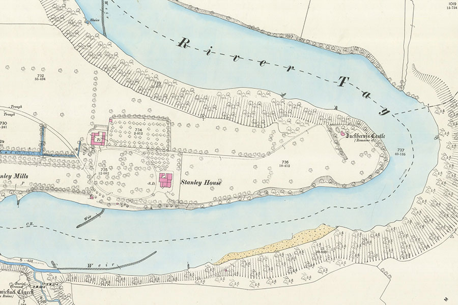
Ordnance Survey, 1867map image courtesy of NLS
In 1876 there were plans for an English Limited Liability Company to take over the mills and estates, who intended to cut down all the trees on the estate to generate cash. Sir Douglas Stewart of Murthly and Grandtully stepped in and helped his relative, Colonel Frank Stewart Sandeman, to take over.
Colonel Stewart Sandeman, a son of Glas and Margaret Stewart Sandeman of Bonskeid and a grand-nephew of Lady Carolina Nairne, ran the mill in parallel with the Manhattan Works in Dundee and helped by his brother, Charles Stewart Sandeman of Springland.
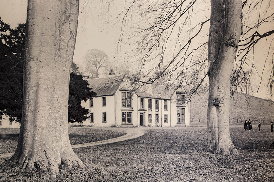
image courtesy of the Perth Museum & Art Gallery
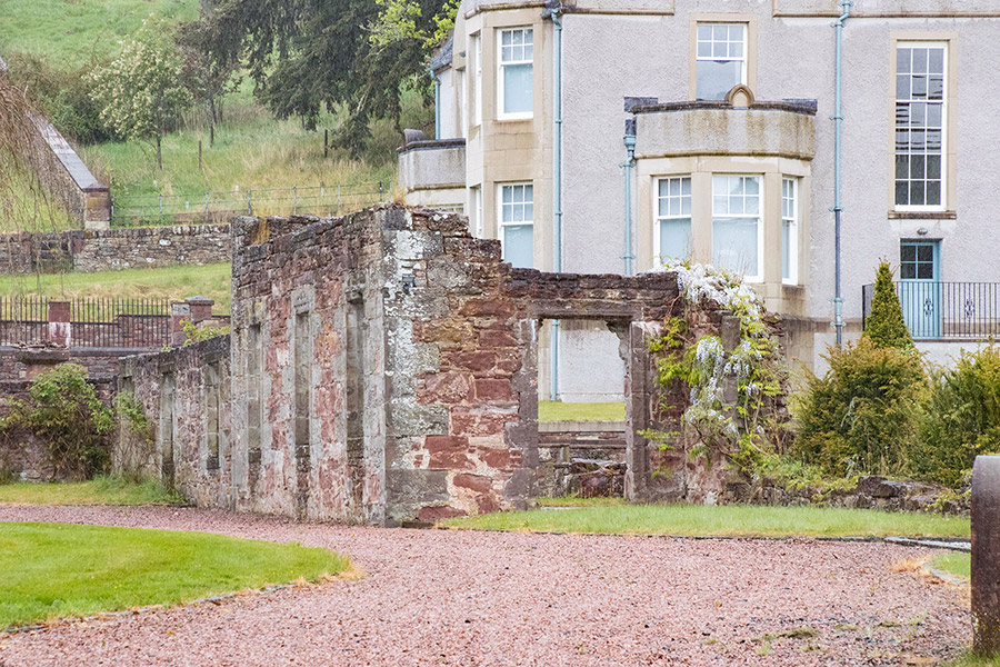
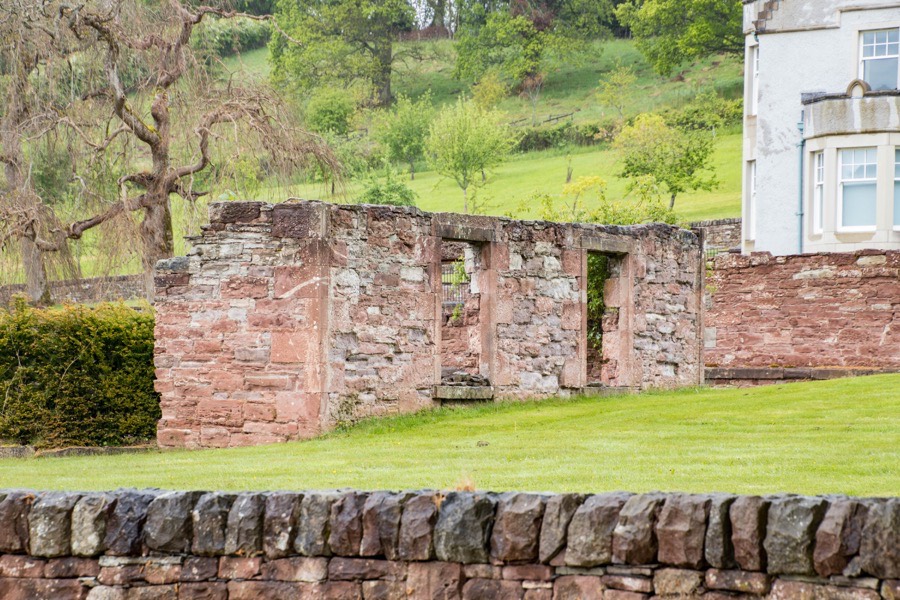
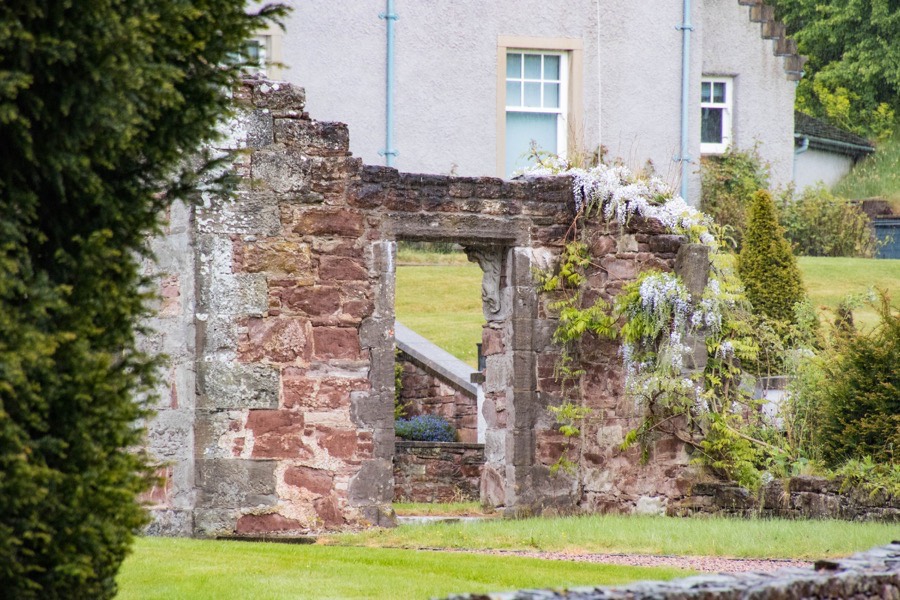
Stanley House was largely destroyed by fire in November 1887 but was at least partially rebuilt as a new iron wing was apparently added for the family to live in. Colonel Sandeman died in 1898 but his wife, Laura Stewart Condie, continued to reside at Stanley House until her death in 1912.
The house, or what was left of it, seems to have been abandoned some time in the early 20th century and left to ruin. In the later 20th century it was partially demolished and in 2006 the remaining walls were lowered and consolidated to create garden enclosures. Some of the stone from the house was used to build new garden walls.
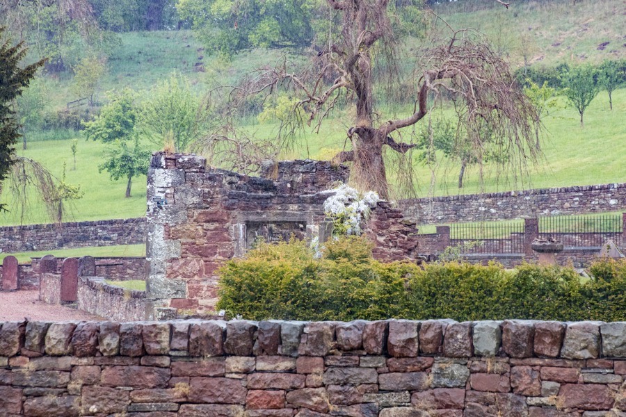
Between 2006 and 2007 a new house, also named Stanley House, was constructed to the north of the old house.


Alternative names for Stanley House
House of Stanley; Stanly