Mowmaynes
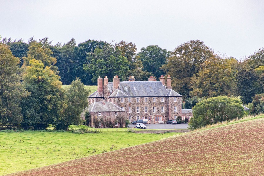
Marlefield House is a 17th century mansion which incorporates part of the earlier tower of Mowmaynes.
The property was previously known as Mowmaynes, Mowmaynis or Mow Mains and seems to have originally been a part of the barony of Eckford which by the mid-13th century was owned by Geoffrey of Ekkeford, better known as Sir Geoffrey de Mowbray, Justiciar of Lothian.
Sir Geoffrey’s third son, Sir Roger de Mowbray, succeeded to Eckford upon his father’s death in 1300, however Sir Roger was involved in a plot to kill Robert the Bruce and replace him as King with William de Soules, Lord of Liddesdale. He was wounded during his arrest in 1320 and died in prison while awaiting trial. Sir Roger’s extensive estates were forfeited to the Crown, and Robert granted Eckford to Walter, Steward of Scotland, the husband of Marjory Bruce.
Later the property was occupied by the Mow or Moll family, a junior branch of Mow of Mow, who seem to have held it from the Newtons of Dalcove.
Mow Mains may be the Mowe-house which was burnt in September 1545 by an English army led by Edward Seymour, Earl of Hertford.
In May 1552 Janet Newtoun of Dalcoif, with the consent of her spouse, Ade Ker de Schaw, and her son and heir, Thomas Ker, sold the lands of Mow-maynes extending to 6 merks, which William Mow of Mow Mains occupied, to William’s son, James Moll.
In 1596 John Mow of Mow Mains and the laird of Mow were troubled by the theft of twenty cows and oxen by George Ker of Crukehalme.
William Mow was served heir to his father, James Moll or Mow, in the lands of Mow-maynes extending to 6 merks with the manor place in October 1606. In April 1610 William Mow of Mowmaynis served as a member of an inquest into the retour of Francis Hamilton as heir to his late father, James Hamilton of Apethsyde. In June of the same year John Mow, son of William Mow of Mowmaynes, was apprenticed to Thomas Mow, a merchant in Edinburgh.
In May 1622 William Mow of Mowmaynes gave the lands of Mowmains to his eldest son, also William, and daughter-in-law, Margaret Ker, daughter of Robert Ker, portioner of Fairnyngtoun.
The younger William seems to have used the land as collateral for a loan as in June 1624 there was a bond of corroboration by William Mow of Mowmaynis and Gilbert Mow, his eldest son and heir apparent, to Sir Henry Wardlaw of Pittrevie. Two years later in August 1626 horning and poinding, the process of having someones property seized by a court, was carried out on behalf of Sir Henry Wardlaw of Pitravie against William Mow of Mowmaynis for payment of bond.
In January 1627 John Mow of Mow sold his lands of Mow-toun, Mow-maynes, Mow-mylne and Carroust, and William and Gilbert Mow of Mowis-maynes sold their lands of Mowis-maynes, to John Wardlaw of Abden, third son of Sir Henry Wardlaw of Pitreavie, to settle an 1100 pound debt to Sir Henry. The list of properties suggests that there were similarly-named lands in the vicinity of Mow Tower.
This may have been a wadset or mortgage of the lands rather than a straightforward sale as in 1630 William Bennet, the minister of Ancrum, received the titles of the lands of Mowmains following a disposition by the said Gilbert Mow of Mowmaynes, as heir to William Mow of Mowmaynes, with the consent of his wife, Margaret Ker. At a similar time Bennet also bought the lands and barony of Grubet from Sir James Ker of Craillinghall. In October 1639 Bennet received a new charter of the lands and barony of Grubet into which were incorporated various other lands including Mowmains.
In June 1647 Bennet’s son and heir, also William, was placed in the ward of Robert Pringle, portioner of Clifton, on account of being underage at the time of his father’s death. He married Christian Morrison, second daughter of Sir Alexander Morrison of Prestongrange, in April 1665 and in November was created a baronet, becoming Sir William Bennet, 1st Bt., of Grubet.
Their son, also William, who was born at Mowmains, married Margaret Sionyall or Scowgall, daughter of the late John Sionyall of Whytekirk, in November 1692 and received a disposition of the lands and barony of Grubet from his father as a part of the marriage contract. This seems to have been reversed two years later however following Margaret’s untimely death.
The younger William married again, wedding Elizabeth Hay, eldest daughter of Sir David Hay of Auchquairns, in August 1695. Possibly in the same year work began on building a new house immediately to the north-west of the old house, work which may have involved Sir William Bruce, a friend of Sir William Bennet.
The new house consisted of a large five bay main block of three storeys plus an attic, with three storey square towers projecting from each corner. The old house was remodelled as an L-plan pavilion, within which an early 17th century bolection-moulded chimney piece survives. A corresponding new pavilion was built to the north, with both pavilions linked to the main house by curved walls. While the house was being built the Bennets are said to have lived at Grahamslaw.
It seems to have been around this time that the name of Marlefield or Marlfield was adopted, with Sir William writing letters to the Countess of Roxburghe from Marlfield in 1702. Vestiges of the old name of the property are preserved on the estate in the Mowses Burn and near the burn a small eminence known as the Mowses knowe.
In February 1703 the younger William received a charter of the lands and barony of Grubbet, following the resignations of his father, Sir William Bennett, and of William Kerr of Cherrytrees. This would suggest that Kerr had some interest in a part of the Grubet lands. The lands were erected into the barony of Grubbet with the manor place of Marlfield made the principal messuage, and a liferent annuity granted to Elizabeth Hay.
Sir William died in 1710 and the younger William succeeded him as second Baronet. The new Sir William was a Commissioner of Excise for Scotland in 1714 and in 1715 led the militia forces of Roxburghshire in the defence of Kelso against the Jacobites. He is sometimes referred to as Captain Bennet, having been appointed a captain of a troop of horse during the Revolution of 1689 and fighting at the Siege of Namur in 1695.
The work on Marlefield is thought to have continued until 1717 and may have latterly involved William Adam. Certainly Sir William is known to have recommended Adam to John Ker, 1st Duke of Roxburghe, for the remodelling of Floors Castle in the 1720s.
Sir William was a great patron of art and literature and was a close friend of the poet James Thomson, whose mother, Beatrix Trotter Thomson, owned lands at Wideopen neighbouring the Grubet lands. Another poet, Allan Ramsay, was a regular visitor and wrote Æolus at Marlefield. Thomson was said to be captivated by one of the “fair Bennetas” as Sir William’s daughters were called by Ramsay.
Following the death of Sir William in December 1729 Marlefield passed to his son, Sir William Bennet, 3rd Bt., of Grubet, however he died without issue in January 1733 and his title and estates were inherited by his brother, Sir David Bennet, 4th Bt., of Grubet. He too died without issue, in April 1741, and was succeeded by his uncle, Sir John Bennet, 5th Bt., of Grubet, the second Baronet’s brother.
In November 1743 Sir John signed a contract with William Nisbet of Dirleton whereby the lands and barony of Grubet would pass to him. Nisbet was the son of William Nisbet of Craigentinny and Dirleton and Christian Bennet, a daughter of the second Baronet.
In 1751 Sir John Bennet died without issue and the baronetcy became extinct. Between 1754 and 1757 repairs and alterations were carried for Nisbet out by George Paterson. The first floor window openings were lowered and on the west rear façade a Venetian central doorway was added with steps leading down to the garden. The pavilions appear to have been rebuilt at this time and were apparently not originally harled.
The grounds were also landscaped, and when George Ridpath, minister of Stitchel, visited Marlefield in January 1758 he noted that Nisbet had removed “a stiff, contracted, Dutch policy” from in front of the mansion and “made a considerable progress in opening and levelling a fine extensive lawn before his house”.
A few years later the Nisbets are said to have abandoned Marlefield, supposedly after Nisbet invited several people to dinner on a Sunday against the wishes of his religious wife. Mr Frain, the tenant of nearby West Wooden farm, occupied the house until it was let around 1775 to Ralph Oliphant, “a gentleman who was highly respected in the district for his amiable and obliging deportment”. A sale of the remaining effects of the Bennets took place before the house was let.
By the mid-19th century Marlefield had been bought by Field Marshal George Hay, 8th Marquess of Tweeddale, although whether he ever lived at the house is unclear. Certainly his main residence at this time was Yester House.
Later in the century the house was apparently lying empty, its condition deteriorating. In November 1890 Athole Stanhope Hay, third son of Sir Robert Hay of Smithfield and Haystoun and a descendant of John Hay, 3rd Lord Hay of Yester, bought Marlefield from William Montagu Hay, 10th Marquess of Tweeddale, third son of the 8th Marquess.
From 1891 the house was remodelled by Kinnear & Peddie, some sources state after a fire. A pediment and sidelights were added to the main front entrance, while the front door lock was brought from Robert Adam’s Calton Jail in Edinburgh. Wood panelling in the hallway was sourced from Cunard liners, Hay’s wife being Caroline Margaret Cunard, daughter of Sir Edward Cunard, 2nd Bt., and sister of Sir Bache Cunard, 3rd Bt.
The house was originally harled with exposed dressings, being described in 1879 as “a long double-winged structure, white-washed, with a superfluity of windows”, however the harling was removed in the mid-20th century revealing the rubble walls underneath.
In the later 20th century the house was run as a hotel but is now once again a private home.


Alternative names for Mowmaynes
Marle-fied; Marlefield House; Marlfield; Maynes de Mow; Moll-manis; Monsmaynes; Mouses Mains; Mow Mains; Mow-Mains; Mow-Maynes; Mowe-house; Mowis-maynes; Mowmams; Mowmaynis; Wowmams