skip to main content
Menu
  • Blog
    • Art & design
    • Castles
    • Cycling
    • Edinburgh
    • Edinburgh Festival
    • Food & drink
    • General
    • History
    • Music
    • Sport
    • Walking
    • Whisky
    • Wildlife
  • Castles
    • Glossary
    • Mottes
    • Stay in a castle
    • Castle blog posts
    • Alphabetical list of castles
    • Castles divided by county
    • Photos of castles
    • Castles we've visited
  • History
    • Castles
    • Ancient history
      • barrows
      • brochs
      • cairns
      • caves
      • chambered cairns
      • cists
      • crannogs
      • cursus monuments
      • forts
      • henges
      • rock art
      • sacred sites
      • souterrains
      • standing stones
      • stone circles
    • Pictish history
      • Pictish stones
      • Pictish sites
      • Pictish placenames
    • Clans
      • Surnames
      • Trace your ancestors
      • Tartan
    • Trace your ancestors
  • Culture
    • Music
      • Bands & musicians
      • Music links
    • Film
    • Television
    • Placenames
      • Pictish placenames
  • Eat
  • Drink
    • Scottish beer
    • Scottish gin
    • Scottish vodka
  • Stay
  • Travel guide
    • City guides
    • Car hire
    • Airports
  • Walking
    • Munros
    • West Highland Way
  • Photos
    • ancient sites
      • Dark Age sites
      • megalithic sites
      • other carved stones
      • Pictish sites
      • Roman sites
    • buildings
    • miscellaneous
    • places in Scotland
  • Offers
  • Home
  • history
  • castles

Leuchat


Military Survey of Scotland
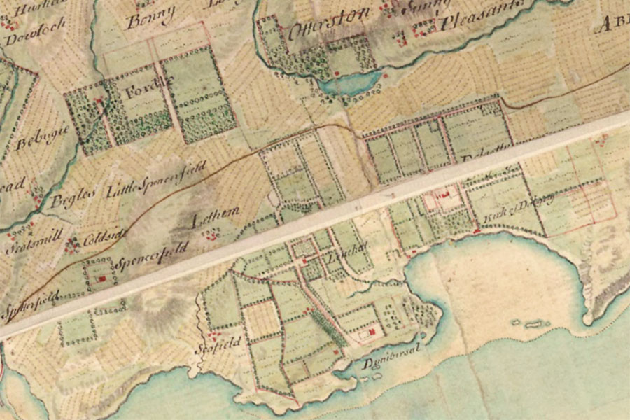
William Roy, 1747 – 1752map image courtesy of NLS

Leuchat was a castle or tower house belonging to the Spittal family between the 16th and 18th centuries but nothing of it now remains.

The first mention of the lands of Leuchat comes around 1220 when Richard, son of Hugh de Camera, granted to Inchcolm Priory an oxgang of land in the territory of Fordell located next to the sea between Dalgety and Leuchat.

Interestingly there is a Leuchat (now known as Leuchold) in Dalmeny parish across the River Forth which may have taken its name from the Fife estate. The two areas were in the possession of Gospatric who was the lord of Inverkeithing and Dalmeny in the 12th century.

In 1428 Sir David Stewart received a charter of the lands of Luchelde (Leuchat) along with the barony of Rosyth from James I but later in the 15th century Leuchat was in the possession of the Spittal family (also spelled as Spittell and Spittall) who were prominent in Fife from the mid-14th century.

What form the castle at Leuchat took and who built it is not known, however it may have been the Spittal family. It occupied a position on rising ground set back from the coast and would have offered commanding views along and across the River Forth and towards Barnbougle Castle on the opposite shore.

Leuchat (written as Lochalde) was the seat of a Willieam Spetell in 1457 however there seems to have been a connection with the church as when John Kers, the Abbot of Inchcolm, retired in 1460 he was permitted to draw a pension from the “lands, farms and annual rents of Donibristle and Bothedlak and the mill and garbal and lesser teinds of the same, together with the garbal teinds of Leuchat”.

A John Spittal of Leuchat witnessed a charter by the bailies of Inverkeithing in 1484 and in 1488 a William Spittal was a bailie of Dunfermline. William was married to Elizabeth Seytoun and bought a one-seventh part of the lands of Fordell from John Seytoun, portioner of Gargunnock in Stirlingshire. I haven’t managed to establish a connection between Elizabeth and John but it may be that they were related.

Around this time the Spittal family seems to have become quite active in the Stirling area and in 1480 Patrick Spittal came into the possession of Blairlogie. This branch of the family would go on to have some influence with James IV.

A William Spetale is recorded in 1523 leasing the mill of Fordell. In 1528 he is recorded as receiving the lands of Balmannoch or Mains of Beith from Thomas Balmannoch, after which they became known as Leuchatsbeath. A document from 1548 “records the excommunication of the Abbey at the instance of William Spittall of Leuchat”. Possibly the same William, or perhaps his son, protested in 1574 at having to build a doocot (James IV having decreed in 1503 that “All lords and lairds to have parks with dovecots etc”).

The Spittal family seem to have been quite wealthy and a household inventory of William, thought to date to around 1580, survives in the Henderson of Fordell papers. William died in 1586 and was succeeded by a James Spittell who was married to Agnes Lundie.

Early in the 17th century, possibly following the death of James Spittell, Alexander Spittal of Blairlogie came into the possession of the lands of Leuchat via a transaction with his relative Margaret Spittal and so united the two estates and branches of the family.

The Gordons’ mid-17th century map of Fife seems to show Leuchat on the coast between Donibristle Castle and St. Bridget’s Kirk. This location is also suggested by Blaeu’s slightly later 1654 map of “The Sherifdome of Fyfe” but Blaeu’s map of “The West Part of Fife”, also published in 1654, shows Leuchat (as Leuchell) slightly inland to the north.

The West Part of Fife
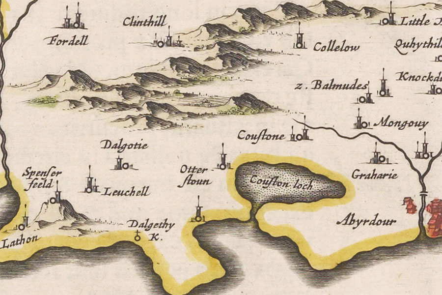
Joan Blaeu, Amsterdam, 1654map image courtesy of NLS

Alexander died in 1654 and a document of 1658 records an agreement made between the owner, presumably Alexander’s son Alexander, and a builder to construct a doocot at Leuchat. The younger Alexander Spittal of Blairlogie and Leuchat was the Member of Parliament for Inverkeithing from 1689 until his death in 1696, and in 1695 Leuchat was erected into a barony for him. He was in turn succeeded by his son, James, who was born in 1664.

James Spittal of Blairlogie and Leuchat went on to become provost of Inverkeithing and the Member of Parliament for the town from 1696 until 1707. He was predeceased by his only son, also James, and so the elder James was succeeded by his grandson, another James, who went on to become a captain in the British Army. The youngest James married Frances Innes in 1741 and their daughter, Elizabeth Spittal of Blairlogie married Robert Dundas of Blair. The Blairlogie estate subsequently passed to the Dundas family.

On Roy’s Military Survey of Scotland published in the mid-18th century Leuchat is shown within landscaped grounds to the north-west of Donibristle, to the east-south-east of Letham and to the west of Dalgety.

Seemingly the eldest James continued to reside at Leuchat until his death in 1760 at the age of 96 but it doesn’t seem to be named on early 19th century maps beyond this. Unnamed buildings marked on subsequent maps in the vicinity of Leuchat’s location suggest it may have been absorbed into the Donibristle estate.

By the time of the mid-19th century Ordnance Survey map the site of Leuchat was seemingly occupied by a “pinery” with walled garden and associated buildings. The walls of the garden are still standing, now surrounding a shopping centre off Regents Way, and Gardens Cottage still stands at the west corner of the garden. The pinery buildings would have been at the end of what is now Carrick Drive. A possible position for Leuchat is to the south-east of the walled garden and that is where I have placed it for now, the site falling within Longhill Park.

stay in a castle
  • advertisement

Alternative names for Leuchat

House of Leegt; Leuchatt; Leuchell; Leuquhet; Lewchatt; Lewquhat; Lewquhatt; Lochalde; Louchat; Louhild; Louchyldd; Lowchald; Lucaht; Luchart; Luchat; Luchatt; Luchelde; Luchett; Luchquhald; Luchquhet; Luchquhit; Luchteild; Luget; Luquhat; Luquhet; Luquhit; Luquhyt; Lwquhat

Surnames associated with Leuchat

Spittal

Spittel

Where is Leuchat?

Leuchat is in the parish of Dalgety and the county of Fife.

Grid reference:NT 15685 83381

Lat / long:56.035871,-3.354725

  • advertisement
Bing Maps | Google Maps | Historic maps (NLS) | OpenStreetMap | Ordnance Survey | PastMap | Streetmap | Wikimapia

OS Map for Leuchat

OS map 350
Edinburgh (Musselburgh & Queensferry)
OS Explorer map 350


OS map 367
Dunfermline, Kirkcaldy & Glenrothes South (Methil & Culross)
OS Explorer map 367


  • advertisement

Directions to Leuchat

Enter a starting point

  • advertisement
  • advertisement

Weather at Leuchat

6°C
max 7°C / min 5°C
9km/h E
1020mb
90%
100%
05:44 18:49

Overcast clouds
Weather observed at Saint Davids at 20:07
  • advertisement

References (books)

Calendar of the Laing Charters
John Anderson
Edinburgh, 1899
Charters of the Abbey of Inchcolm
D.E. Easson
Edinburgh, 1938
Register of Marriages of the City of Edinburgh, 1751-1800
Francis J. Grant
Edinburgh, 1922
Scotland and the Americas, c. 1650 - c. 1939
Various
Edinburgh, 2002
Scottish Arms Volume 2
R. R. Stoddart
Edinburgh, 1881
The Commissariot Record of Edinburgh - Register of Testaments 1514-1600
Francis J. Grant
Edinburgh, 1897
The Commissariot Record of Edinburgh - Register of Testaments 1601-1700
Francis J. Grant
Edinburgh, 1898
The History of the Sufferings of the Church of Scotland (Volume IV)
Robert Wodrow
Glasgow, 1832
The Oliphants in Scotland
Joseph Anderson
Edinburgh, 1879
The Peerage of Scotland
Robert Douglas
Edinburgh, 1764
The Register of Marriages for the parish of Edinburgh, 1701-1750
Henry Paton
Edinburgh, 1908
The Scots Peerage (Volume 5)
James Balfour Paul
Edinburgh, 1908

Castles near Leuchat

Donibristle Castle (site of)

0.6km away

Letham (site of)

0.9km away

Dalgety House (possible) (site of)

1.2km away

St David's Castle (site of)

1.3km away

Spencerfield House

1.6km away

Couston Castle

2.0km away

Otterston Tower

2.1km away

Balbougie

2.2km away

Fordell Castle

2.2km away
more castles....

Ancient sites near Leuchat

Cammo Stone standing stone

8.9km away

Hopetoun Wood standing stone

9.7km away

Lochend standing stone

11.2km away

Huly Hill barrow and standing stones

11.3km away

Inchgall (possible) crannog

12.6km away

Edinburgh Castle fort

13.6km away

Wester Craiglockhart Hill fort

15.1km away

Arthur's Seat fort

16.0km away

Samson's Ribs fort

16.1km away
more ancient sites....
  • advertisement

Pictish stones near Leuchat

Princes Street Gardens Class I symbol stone

13.5km away

Abernethy No. 2 Class III symbol stone

14.2km away

Abernethy No. 4 Class III cross shaft

14.2km away

Tullibole Class III cross slab

20.2km away

Court Cave Class I rock carving

23.0km away

Doo Cave Class I rock carving

23.1km away

Jonathan's Cave Class I rock carving

23.4km away

Sliding Cave Class I rock carving

23.4km away

East Lomond Hill Class I symbol stone

24.4km away
more Pictish stones....

Pictish sites near Leuchat

Norrie's Law hoard

34.8km away

Haddington silver chain

37.0km away

Borland silver chain

38.4km away

Todholes (possible) silver chain

39.5km away

Traprain Law silver chain

43.3km away

Whitlaw silver chain

49.1km away

Hoardweel silver chain

67.0km away

Whitecleugh silver chain

72.1km away

Dunnicaer fort

124.9km away
more Pictish sites....
  • Thrifty Rent-A-Car System, Inc.
  • Sixt Car Rental

Accommodation near Leuchat

Boreland Lodge hotel
hotelInverkeithing
2.4km away
Woodside Hotel
hotel, restaurantAberdour
3.7km away
Queensferry Hotel
hotelNorth Queensferry
4.0km away
Premier Inn Dunfermline
hotel, restaurantDunfermline
5.4km away
Orocco Pier
hotelQueensferry
5.7km away
Pitbauchlie House Hotel
hotelDunfermline
5.9km away
King Malcolm Hotel
hotelDunfermline
5.9km away
Premier Inn Edinburgh Airport (Newbridge)
hotel, restaurantEdinburgh
6.0km away
Dakota Forth Bridge
hotelSouth Queensferry
6.0km away
Express by Holiday Inn Dunfermline
hotelDunfermline
6.1km away

Accommodation search

(leave blank to view all)
Accommodation type
bed and breakfasts
campsites
castles
holiday parks
hostels
hotels
self-catering apartments
self-catering cottages
self-catering lodges
spas
  • advertisement
more accommodation....

Cafés, restaurants & bars near Leuchat

Woodside Hotel
hotel, restaurantAberdour
3.7km away
Papa Joe's Dunfermline
restaurantDunfermline
5.3km away
Premier Inn Dunfermline
hotel, restaurantDunfermline
5.4km away
The Two Bridges
restaurantSouth Queensferry
5.5km away
Premier Inn Edinburgh Airport (Newbridge)
hotel, restaurantEdinburgh
6.0km away
Auld Mill House Hotel Bar and Restaurant
hotel, bar, restaurantDunfermline
6.3km away
The Hideaway Restaurant
restaurantDunfermline
6.5km away
Premier Inn Edinburgh (South Queensferry)
hotel, restaurantEdinburgh
6.6km away
Craigie’s farm deli and café
caféSouth Queensferry
7.0km away
Best Western Keavil House Hotel
hotel, restaurant, barCrossford
9.4km away
more food.... / more drink....

Related pages

Dirleton Castle in East Lothian
Garden of Cosmic Speculation plus castles
Inveraray Castle and standing stone
A doocot, a castle and a beach in East Lothian
A pair of castles on the River Tweed
Dunbar harbour and castle
Published on the 15th of August 2018 at 5:14 pm. Updated on the 8th of July 2019 at 11:10 am.

Leave a comment

back to the top of the page

Connect with us

Like us on Facebook

Receive our newsletter

Follow us on Twitter

Tweets by Stravaig_Aboot

Quick links

Stay in a Scottish castle
Edinburgh Festival accommodation
Hotels in Scotland
Car hire in Scotland
Places to eat and drink in Scotland
Castles in Scotland
Trace your Scottish ancestors
Scottish clans
Standing stones in Scotland
The Picts
Pictish symbol stones
Pictish placenames
Scottish bands and musicians
Scottish films
Scottish TV shows
West Highland Way

About

Andy Sweet above Fast Castle

Stravaiging around Scotland is written, photographed and researched by Andy Sweet.
read more....

Cookies

To make this site work properly we use cookies to store information on your computer. Click here to read more.
© 2003 - 2023 Andy Sweet / Stravaiging around Scotland. Powered by WordPress. Hosted by Tsohost.