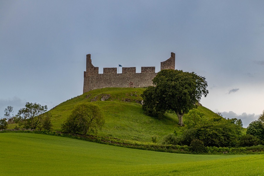
Hume Castle
Hume Castle is a late 18th century folly which was built on and from the remains of a late 12th or early 13th century castle belonging to the Home family.
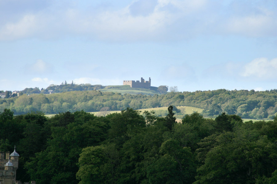
The site is of significant strategic importance, located around 10km from, and offering views to, the English border. The castle stands on a flat-topped 224m tall rocky outcrop which rises from a ridge lying within a triangle formed by the settlements of Gordon, Greenlaw and Kelso. It is clearly visible from many places in the surrounding landscape, including from several other castles, and has views north to the Lammermuirs, east along the Tweed valley, south to the Cheviots and beyond the Eildons to the west.
Exactly when the first castle was built here is unclear. A village and church dedicated to St Nicholas are known to have existed by the mid-12th century and it may well be that there was a contemporary castle however the first specific mention of it does not appear until later in the century.
The lands of Home, as it was also known, were granted as a dowry to Ada, daughter of Patrick, Earl of Dunbar, in 1214 when she married William de Courtney. Her husband died around 3 years later and in 1219 she married Theobald de Lascelles. She was widowed for a second time in 1225 and subsequently married her cousin, William, son of Patrick of Greenlaw, who took the surname Home.
Later rebuilding work has obscured the form of the original castle, however a 3D aerial survey in 2015 revealed previously undiscovered details which give an insight into the site’s development. A rampart to the east of the present structure’s walls has been interpreted as the possible remains of a timber and earthwork castle with further outworks at the western end of the outcrop’s platform.
The survey also revealed that there had been a wall to the west of the present west wall with a round tower sited in front of the current entrance and a second round tower projecting from the north wall. It has been suggested that these represent the remains of a castle on a courtyard plan which may have replaced the timber and earthwork construction in the 13th or 14th centuries. During the Wars of Independence in the early 14th century the village was devastated by English attacks and the castle almost certainly suffered a similar fate, although it’s said that it was the only Borders castle not destroyed by Robert the Bruce’s scorched earth policy prior to the Battle of Bannockburn.
In 1424 Sir Alexander Home of Home was killed fighting the English at the Battle of Verneuil in Normandy and was succeeded by his son, also Sir Alexander, a product of his marriage to Jean, daughter of Sir William Hay of Locherworth. The younger Sir Alexander married Mariotta or Marion, daughter and co-heiress of John Lauder, the son of Sir Robert Lauder of Edrington and The Bass.
Their eldest son, another Alexander, married Elizabeth or Agnes Hepburn, daughter of Sir Adam Hepburn of Dunsyre, Master of Hailes, succeeded following his father’s death, the date of which is variously given as 1456 or 1461.
In 1451 James II conceded to the younger Alexander the lands of Dunglass, Home, Susterpeth (Sisterpath), and Kello, which his father resigned, and erected them into the free barony of Home. The following year the lands of Chirnside were annexed to the barony, and further lands were added in 1452.
The elevated position and visibility in the landscape led to the castle being used as a beacon station to warn of English invasions. The first beacon would be lit at Hume which would then be seen from the second at Edgarhope Castle. The third beacon was described as being on Soutra Edge which would in turn be seen from Edinburgh Castle.
In 1460 James II and his wife Mary of Guelders stayed at Hume Castle, the King using it as a base from which to attack Roxburgh Castle which was occupied at that time by the English.
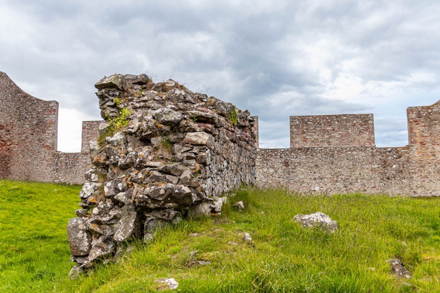
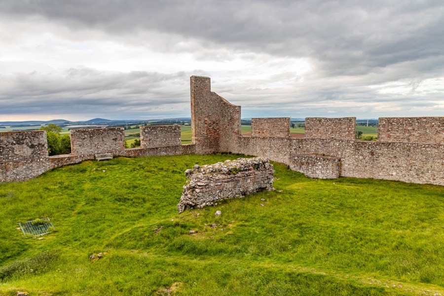
Alexander was created Lord Home in 1473 and around 1475 he was appointed Warden of the Eastern March. The castle was redeveloped in the 15th century, possibly to reflect Lord home’s new status, with a tower built within the courtyard and artillery defences constructed. A large section of wall from the tower, measuring around 8.0m long by 3.0m tall and 1.5m thick, complete with slight evidence of vaulting can still be seen within the castle’s walls. To the north-west of the tower was a well sunk into the rock, measuring around 1.5m in diameter and lined with squared stonework.
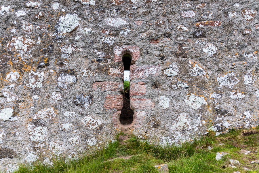
A 15th century dumbbell gun loop can be seen built into the present west wall to the north of the current entrance, along with an arrow slit and what has been interpreted as a drain. It isn’t clear if they are in their original positions.
The 1st Lord Home died in 1490 or 1491 and was succeeded by his grandson, also Alexander, his son, another Alexander, having predeceased him. The 2nd Lord Home was made Lord Chamberlain in 1488 following the the Battle of Sauchieburn and the following year was appointed Warden of the Eastern March, dying in 1506.
Alexander Home, 3rd Lord Home, succeeded his father in the positions of Lord Chamberlain and Warden of the Eastern March in 1506. In 1507 he bought the lands and burgh of Gordon from Alexander Gordon, 3rd Earl of Huntly and in 1509 he was appointed Warden of the Middle March.
Home and Huntly’s men formed the vanguard of the Scottish forces at the Battle of Flodden in 1513 and Home’s cavalry defeated the right wing of the English Army during the ultimately unsuccessful conflict. James IV died on the battlefield and what was reputed to be his body was taken to London, however legends persist that this was not the King. As penance for his involvement in the death of his father, James wore an iron chain around his waist during Lent. The fact that the body transported to London did not feature such a chain is given as justification for it not being that of the King, however the Battle of Flodden occurred in September when the King presumably would not have been wearing his chain.
One legend states that four Home horsemen collected the King’s body and took it back to Hume Castle where it was hidden in a cave off the castle’s well. A skeleton with a chain around its waist is said to have been discovered in the well in the 18th century but was later apparently lost. A second version has it that the body was discovered at Hume a few years after the battle and re-interred at Holyrood Abbey. Both seem rather fanciful.
What is true is that following the King’s death Lord Home didn’t accept the authority of the Regent, John Stewart, Duke of Albany which brought them into conflict. On the 10th of August 1515 Albany demanded “the surrender of the castles of Home, Thornton, Fastcastle, Newark, Dunglass and Samuelston.
Later in August Hume Castle was captured by Regent Albany and members of the Home family, including “Davy Hume, the Lord of Wetherborne, Sandy Hume, the Lord Blayneherne, and Adam Tunno, the constable of Hume” were imprisoned at Dunfermline.
Lord Home recaptured Hume Castle on the 26th of August and destroyed it to prevent it from falling again into Albany’s hands.
….the next day after winning the Castel the Lo. Chamberlayn, with masons of Norham and others, pulled it downe, and destroyed furst the foore gate, the hall, and the chambers, nd carried away all the leed and tymbre, and hath rasid all the batilments of the wallis that coude not be brought downe, and also hayth destroyed all the stayrs, vawths (vaults?), bakehouse, and brewhouse, and also hath dampned the well for ever moore, so that they can have no releefe of water within a greate space of the said castell.The History and Antiquities of North Durham
James Raine, London, 1852
Lord Home was enticed to meet the French ambassador at Dunglass with the offer of an amnesty and pardon, however he was captured and imprisoned in Edinburgh Castle at Albany’s behest. Home escaped along with his jailer however, his jailer being his brother-in-law James Hamilton, 1st Earl of Arran. Home then attacked Dunbar Castle and captured Sir William Cumming of Inverallochy, Lord Lyon King of Arms, at Coldstream.
Lord Home exchanged the Lord Lyon for his mother who was being held prisoner by Antoine d’Arces, Sieur de la Bastie, a French ambassador and trusted lieutenant of Albany’s who had been appointed Keeper of Dunbar Castle in December 1514. Eventually Lord Home and his younger brother, William, were arrested and charged with treason, forfeited, executed and their heads displayed in Edinburgh.
The Homes sought revenge and in 1517 intercepted d’Arces on his way from Dunbar Castle. His horse became stuck in boggy ground and George Home, brother of Sir David Home of Wedderburn, cut off the Frenchman’s head and displayed it on a pole in Duns.
The family’s estates and titles were restored in 1522 and the late Lord Home’s brother, George, became the 4th Lord Home. In 1547 during the Rough Wooing an English army under Edward Seymour, 1st Duke of Somerset, invaded Scotland and on the eve of the Battle of Pinkie the Homes were caught in a skirmish with the English near Fa’side Castle. Lord Home was wounded and his son, Alexander, captured.
Following the English victory at Pinkie, Somerset attacked and laid siege to Hume Castle which was being defended by George’s wife, Mariotta. Lady Home surrendered after two weeks when Somerset threatened to execute Alexander. After taking possession of the castle the English rebuilt and strengthened the defences, with the new Alexander taken to England as a hostage. In 1548 he was released and with his brother, Andrew, Commendator of Jedburgh, attacked and recaptured the castle. The English attempted to recapture the castle in February 1549 but were repelled and it remained in Home hands.
Lord Home pledged allegiance to Mary Queen of Scots and she spent two nights at Hume Castle in 1566 with Lord Darnley. The following year however Lord Home switched sides and he fought for Regent Moray at the Battle of Langside in 1568. In 1569 changed sides once again and Hume Castle was captured by an English force commanded by Thomas Radclyffe, 3rd Earl of Sussex. Lord Home was taken prisoner in 1571 during a skirmish with James Douglas, 4th Earl of Morton, in the suburbs of Edinburgh. He seems to have escaped or been released at some point since he later joined those involved in holding Edinburgh Castle for the Queen during the Lang Siege. After it fell in 1573 he was imprisoned for treason but later pardoned and restored, dying in 1575.
Lord Home’s widow (and second wife), Agnes Gray, was given funds in the 1570s by the Earl of Morton, now Regent Morton, to garrison Hume Castle for James VI. It may be that this was when a sloping section of the south wall was built. It has been interpreted as evidence of an artillery defence dating to the late 16th or early 17th centuries.
In 1578 Lord Home’s widow complained to Regent Morton that Hume Castle was being occupied by her late husband’s brother, Andrew Home, in whose care her young son and 6th Lord Home, Alexander, had been placed. Initially the Commendator was ordered to give up the castle but in 1579 it was agreed that it should be retained in the name of Lord Home with the Commendator allowed to continue in residence. In 1581 various people, including Alexander Home of Manderston, were ordered to restore certain lands to Lord Home.
The 6th Lord Home was involved in various disputes with Francis Stewart, 5th Earl of Bothwell, the cousin of James VI who would later try to oust the King, and Home was made captain of the King’s bodyguard. He accompanied James VI on his journey to England in 1603 and in 1605 he was created Earl of Home.
By 1611 the Home family had moved to The Hirsel and in 1619 the Earl of Home died in London. He was succeeded by his son, James Home, as 2nd Earl of Home, who died without issue in 1633 and the earldom passed to Sir James Home of Cowdenknowes.
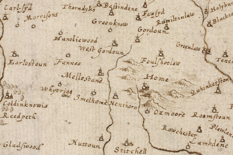
Robert Gordon, c. 1636 – 1652map image courtesy of NLS
Hume Castle saw action again during the Wars of the Three Kingdoms and in 1645 it was garrisoned with a company of soldiers from the Earl of Lothian’s regiment. Later it was held by Colonel John Cockburn of Caldra during an attack by Cromwell’s forces under Colonel George Fenwick in 1651. The castle was surrendered and destroyed by the Parliamentarian troops. Almost a century later the castle was apparently held by Government forces in 1745 to prevent it being used by the Jacobites however it seems to have been but a ruin by this time.
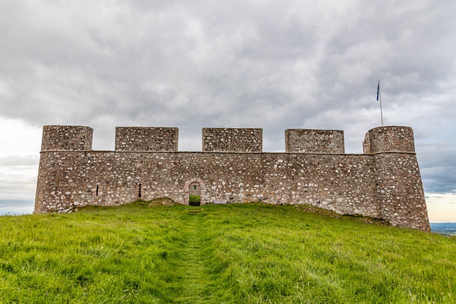
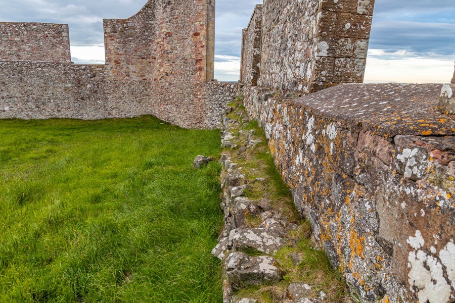
In 1766 Sir Hugh Hume-Campbell, 3rd Earl of Marchmont, a member of another branch of the Home family descended from the Manderston Homes, bought the barony of Hume along with Hume Castle. Sir Hugh rebuilt the castle as a folly, work which was completed in 1789. The courtyard wall now measures around 40m by 45m on a slightly trapezoidal quadrangular plan. The exaggerated crenellations are said to have been constructed so as to be clearly visible from the Earl’s new seat of Marchmont House, built in 1750 some 6km to the north-east.
During the Napoleonic Wars the elevated position of the castle led to its use once again as a signalling beacon to warn of invasion, with a beacon stance built at the south-west corner of the walls. On the 31st of January 1804 the beacon was lit when a member of the Berwick Volunteers saw a fire to the south and mistook it for another warning beacon. This led to the lighting of a chain of beacons through the Borders and the turnout of 3000 volunteers in what became known as The Great Alarm.
In 1929 Hume Castle was acquired by the State and in 1931 the Berwickshire Naturalists’ Club erected a viewfinder on the Napoleonic beacon platform to mark their centenary. During World War II the castle served as an observation post but this seems to have been its last functional use.
In the early 1980s the castle closed to the public however in 1985 a programme of restoration began, with funds from the Scottish Office administered by the Berwickshire Civic Society. The castle and the site of the old village were surveyed in 1987 as part of the Border Burghs Archaeology Project. In 1992 the castle re-opened to the public and in 2006 the Berwickshire Civic Society transferred ownership to the Hume Castle Preservation Trust, a charitable trust operated by the Clan Home Association.


Alternative names for Hume Castle
Castle Hume; Castle of Home; Castle of Hume; Haymo; Home; Home Castle; Hoom; Hoome; Hoome Castle; Houme; Howin; Howin Castle; Howyn; Howyn Castle; Hummes; Hwm; Hwme; Hwym