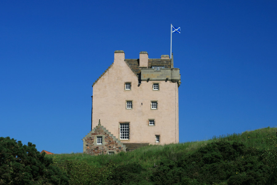
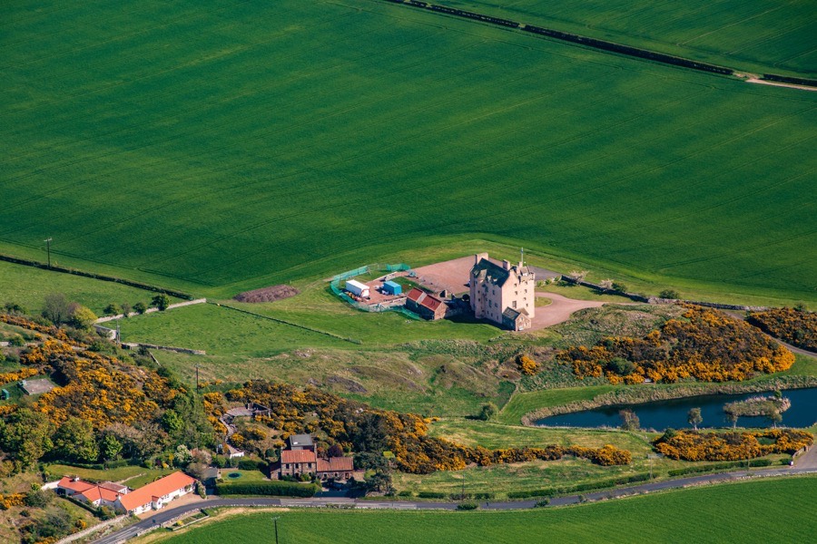
Fenton Tower
Fenton Tower is a restored 16th century L-plan tower house standing amongst gently rolling farmland in East Lothian.
The history of the site may date back to 11th century, with a tower reputed to have been built in the 12th century although there is no documentary evidence of this and as yet no archaeological proof. An early church existed nearby to the north at Kingston Common where some forty one early Christian long cist burials were discovered along with pottery dating to between the 12th and 14th centuries.
When the first castle was built at Fenton is unclear, however it occupies a site of some strategic importance. It stands on a rocky outcrop on the lower slopes of Kingston Hill with commanding views over the surrounding area farmland and beyond to the coast.
The land was owned by de Vaux family during the reign of David I in 12th century and around 1150 it is mentioned in charters of Dryburgh Abbey as Ester, Estir and Estyr Fenton. In the late 12th century Gregory of Fenton witnessed a grant of land near Cargill Castle in Perthshire, and in either the late 12th or early 13th century he was a witness to a grant by William de Vaux of land at Gullane to the monks of Durham.
Some time before the end of the first quarter of the 13th century, during the time of Sir John of Fenton, William de Vaux gave various land in Kingston and Fenton to the priory of Lanercost although this doesn’t seem to have included Fenton itself, instead being a toft and a field in the territory of Kingston known as Withelau or Quitelav (probably Whitelaw or Whytelaw) and a field in the territory of Fenton next to Kingston Muir.
Around 1237 Sir John’s son, Sir William, married Cecilia Bisset, the co-heiress of John Bisset of Lovat, and later came into the possession of Beaufort Castle as a result.
In 1244 Sir John of Fenton was listed as an oath-taker for Walter Comyn, Earl of Menteith, when Scottish knights agreed not to commit transgressions against Henry III of England, suggesting that he was a person of some note. At some point in the 13th century Sir John was given two tofts and two acres of land along with fisheries at Inchyra in Perthshire by John of Inchyra.
Around the same time Robert, son of Walter of Congalton, received from the prior of Lanercost, for his homage and service, the land which de Vaux had given them in Kingston.
Sir William of Fenton witnessed Alexander de Vaux’s grant of the island of Eldbotle to the canons of Dryburgh around 1255. By this time however the Fentons’ focus seems to have shifted north, with their principal seat then being at Baikie in Angus and in 1261 John de Fenton was sheriff of Forfar.
In the third quarter of the 13th century Sir William was in dispute with Sir David of Graham regarding land at Kiltarlity in Inverness-shire. During the fourth quarter of that century he granted to Sir Nicholas de la Haye, lord of Errol, the lands and fisheries at Inchyra given to his father, Sir John.
Sir William was one of Robert the Bruce’s auditors appointed during the arbitration for the Crown of Scotland in 1291 and 1292. John of Fenton, is mentioned in a plea roll of Edward I of England’s army at Berwick in 1296 and Walter of Fenton performed fealty to Edward in the same year. A document from January 1300 refers to the late Walter of Fenton owning a tenement within the town of Berwick. John campaigned with Robert the Bruce and signed the Declaration of Arbroath in 1320.
Early in the 14th century a presumably later William de Fenton gave his lands of Auchindorie or Auchindory in Angus to Coupar Angus Abbey for the salvation of his soul. In 1328 Master John of Fenton was described as a doctor law when witnessing Robert the Bruce’s promise to pay £20,000 to Edward III of England as part of the Treaty of Edinburgh.
A William de Fenton paid homage to the new king Robert II in 1371 and in 1385 the presumably de Vaux baron of Dirleton confiscated William’s tenement of Fenton and his “fermes and goods” but William successfully petitioned parliament for their return. In 1413 William of Fentoun acquired the lands of Quodquen in Lanarkshire. A John de Fentoun was a burgess of Edinburgh in 1426 and a Thomas of Fenton was a merchant in the sheriffdom of Forfar in 1432.
The year 1479 seems to have been one of disputes for the Fentons. John Kennedy, 2nd Lord Kennedy, and his wife Elizabeth Gordon, Countess of Erroll, pursued George of Fenton and Elizabeth Fenton for withholding produce from their farms at Clochtow in Angus and Callerty respectively.
In the same year Robert of Lauder of Edington pursued a case against John of Fenton of that Ilk “regarding the spoilation of 2 oxen from the lands of Sydserf“.
Also in 1479 John requested that Alexander Sydserf of that Ilk prove ownership of the lands of Chapelside and Sydserf since John claimed the rent from those lands was rightfully his.
In 1494 Alexander Mowat of Lescraigie denied that he had served Henry Douglas as heir to the late Janet of Fenton in her lands of Dunblat, Cowes and Antheris.
Around 1525 the Lowland Fenton line seems to have failed when Elizabeth, sister and heiress of John de Fenton of that Ilk married a Whitelaw of that Ilk and Fenton passed into the ownership of that family. A Johne Quhitlaw is recorded in the rental records of Dryburgh Abbey as in possession of “Est fentoun” around 1540.
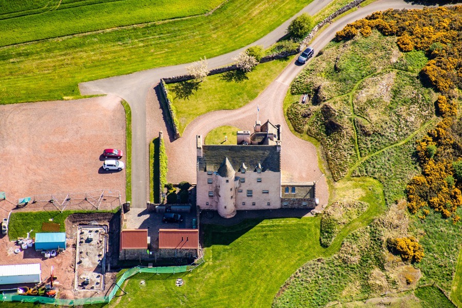
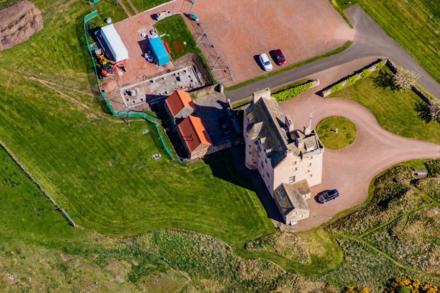
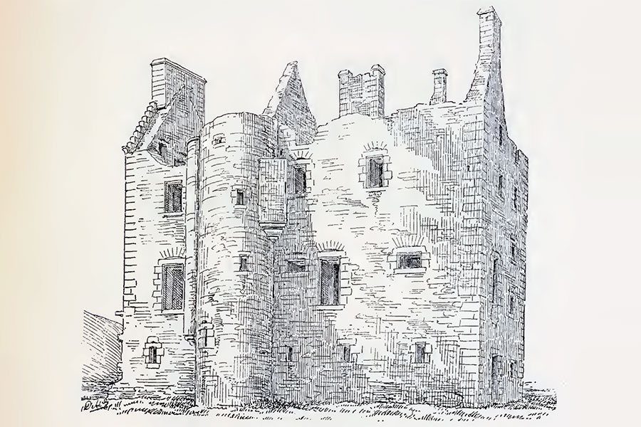
The current tower is thought to have been built around 1550 by Patrick Whitelaw of that Ilk. It consists of a main block aligned approximately east to west which measures around 17.4m long by 7.4m across and rises to a height of three storeys and an attic, with walls around 1.3m thick. Projecting from the south edge of the west end is a small wing measuring around 5.2m by 4.0m with a doorway in the re-entrant angle on this wing. The doorway gives access to the vaulted basement at ground floor level and also a half-circle spiral staircase leading up to the first floor.
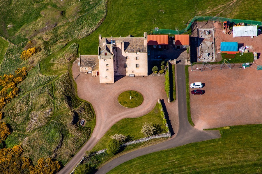
Towards the east end of the north side of the main block projects a semi-circular stair tower rising to the full height of the building. Aligned with this on the interior is a spine wall also rising the full height and dividing each floor into two unequal sections, the western most section representing around two thirds of the space and the eastern most section around a third. This may be evidence of an earlier smaller tower which was later extended.
There was no kitchen in the basement which is unusual for a tower house of this purported age however it may suggest that the tower incorporates an earlier structure. It is known that an ancillary building was once built on the west side of the main block and this may have contained a kitchen. The only other features of note were a pair of aumbries flanking a later door through the west end of the larger chamber to the ancillary building, and a doorway at the north-west corner of the smaller chamber leading to a second spiral staircase.
On the first floor the larger west chamber measures around 10.7m long by 5.5m wide and contained the hall, with a large fireplace on the south wall. The smaller eastern chamber measures around 5.2m long by 5.1m wide and features a smaller fireplace in its east wall. In both chambers the ceiling height was around 4.4m. A further chamber was contained in the projecting wing.
From the first floor a small corbelled-out tower in the re-entrant angle gives access to a spiral staircase leading to the upper floors, in addition to the aforementioned staircase in the northern stair tower. The second floor is much lower than the first, achieving a height of just over 2.0m. The larger chamber to the west measures around 9.5m by 5.3m and was subdivided with a wooden partition, each chamber having its own fireplace. The smaller chamber to the east measured around 5.2m by 5.0m and has a fireplace in its east wall, mirroring the chamber below. As on the first floor there was a further chamber within the projecting wing.
The attic level was similarly arranged with three further chambers in the main block and another either within the projecting wing or placed on top of it within a parapet walk. At the two south corners of the wing round towers were corbelled out.
To the south of the tower is a flat terrace enclosed by scarped edges which are thought to represent the footings of a barmkin wall. Within this enclosure, and parallel to the tower’s main block, is a turf-covered mound measuring around 15.0m long by around 5.0m which may represent an ancillary building.
Patrick Whitelaw fought for Mary Queen of Scots at the Battle of Langside and was subsequently accused of treason in 1568 and his estates forfeited. The Crown then granted “the lands of Quhitlaw, the lands of Fentoun called Oversydserf….and the towers, fortalices and manors of the lands of Quhitlaw and Fentoun” to Sir John Carmichael of Carmichael in May 1571. Another charter of 1576 refers to the “lands of Over Sydserf or Fentountoure”, so mentioning the tower specifically.
The dendrochronological analysis of timbers used as floor joists revealed one example firmly identified as having been felled in Scandinavia in the spring or summer of 1572, probably in Norway. This obviously doesn’t match up with the purported construction date of 1550 however it may have been the case that Carmichael undertook significant remodelling work of the early tower with the timber having been stored for several years prior to use.
Other timbers were identified as having come from southern Sweden and Denmark, with one example possibly coming from north Germany. The date ranges of these was wider, although also likely to have been in the 16th century, and this range may indicate two periods of construction. Certainly the lower two storeys of the tower were built with dark grey basalt while the upper storeys used red sandstone, perhaps suggesting they were built at different times.
A carved panel, now lost but heavily weathered when last seen in the 19th century, which was once installed above the doorway is said to have carried the date of 1577 and the initials JC for Sir John Carmichael of Carmichael and may have marked the completion of this later construction or remodelling work.
In 1581 Carmichael’s fortunes changed for the worse when he and his son, Hugh, were charged with treason for their support of James Douglas, 4th Earl of Morton. They seemingly went on the run but later returned and Carmichael senior participated in the Raid of Ruthven in 1582 for which he was charged with treason once again. He apparently fled the country and in 1584 a summons was affixed to the gate of Fenton Tower requesting Carmichael to appear before the King to answer the charge.
John Carmichael, younger, of that Ilk petitioned James VI in 1585 for the return of “the lands of Fenton, tower, mills and pertinents thereof pertaining to him” and in 1587 the King declared that any “pacification, restitution and abolition made in favour of the bairns and heirs of the late Patrick Whitelaw of that Ilk at any time heretofore, or that shall happen to be made and granted in their favour at any time hereafter, shall in no way be extended to the lands of East Fenton, commonly called Fenton Tower of Oversydserf, with the tower, fortalice, manor places, houses, buildings, yards and pertinents of the same”.
By 1587 the elder Carmichael seems to have been back in favour with James VI and he was regranted “the lands of East Fentoun commonly called Fentountoure or Ovir Syidsarff, with its fortalice and manor place”. In 1588 he was an ambassador to Denmark who helped to negotiate the King’s marriage to Anne of Denmark. Carmichael accompanied the King to Denmark late in 1589 for the marriage at the Old Bishop’s Palace in Oslo in November, returning in April 1590 just ahead of the King and Queen’s arrival at Leith on the 1st of May 1590. The King and Queen visited Fenton several times in the coming years.
In 1592 Carmichael was in dispute with the laird of Innerwick regarding ownership of Fenton. Patrick Whitelaw’s daughter and heiress, Margaret, married Sir Alexander Hamilton of Innerwick and their son, also Sir Alexander, was styled as “of Fenton” despite his grandfather’s forfeiture. Sir Alexander died without issue and seemingly so did the Hamilton claim to Fenton as in June 1592 there was a confirmation of ownership in favour of Sir John Carmichael of that Ilk.
Later that month James and Anne were staying at Falkland Palace in Fife when it was surrounded and attacked by a band of rebels led by Francis Stewart, 5th Earl of Bothwell. The attack was repulsed and the monarchs escaped by boat from Earlsferry to North Berwick and on to Fenton Tower where they were put up by the Carmichaels.
In 1594 James seems to have granted Fenton Tower and its lands to David Murray of Cockpool, although for what reason isn’t clear. Carmichael was made Warden of the Scottish West March in 1598 which brought him into contact with the notorious Armstrong Border Reivers and after some perceived sleight in 1600 he was murdered by members of the Armstrong family.
James VI then granted Fenton to Sir Thomas Erskine, later Lord Dirleton, Viscount Fenton and Earl of Kellie, in the same year. Erskine had killed Alexander Ruthven at Gowrie House in Perth during the latter’s struggle with the King. However by 1607 Fenton may have been in the possession of Patrick Whitelaw’s heiress and daughter, Margaret, as in that year she granted “a third part of the lands of Over Sydeserf alias Fentountour with its fortalice” to her husband, Sir Alexander Hamilton of Innerwick.
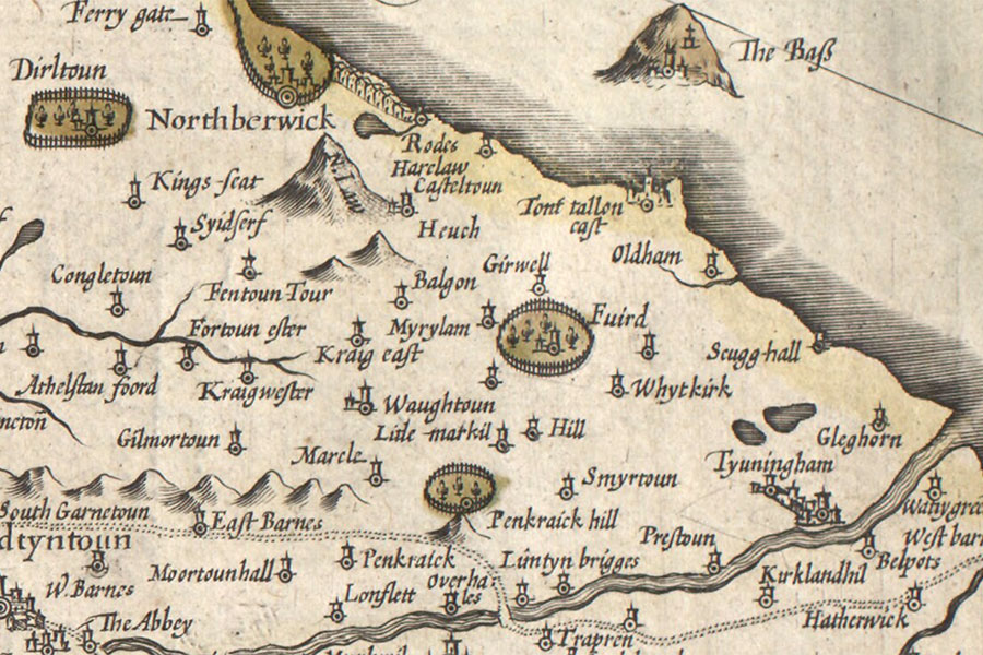
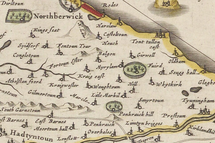
Hendrik Hondius, Amsterdam, 1630map image courtesy of NLS
In 1631 Fenton passed to Sir James Maxwell of Innerwick, who became Earl of Dirleton in 1646, possibly by marriage. Sir James Maxwell of Calderwood, possibly a relation, had married Isobel or Elizabeth Hamilton, daughter of Sir Alexander Hamilton of Innerwick.
When Cromwell invaded Scotland in 1650 and sacked Dirleton Castle some sources state that Fenton was also attacked and the tower left in ruins while other sources state that only the roof was removed or damaged but the rest of the castle left intact.
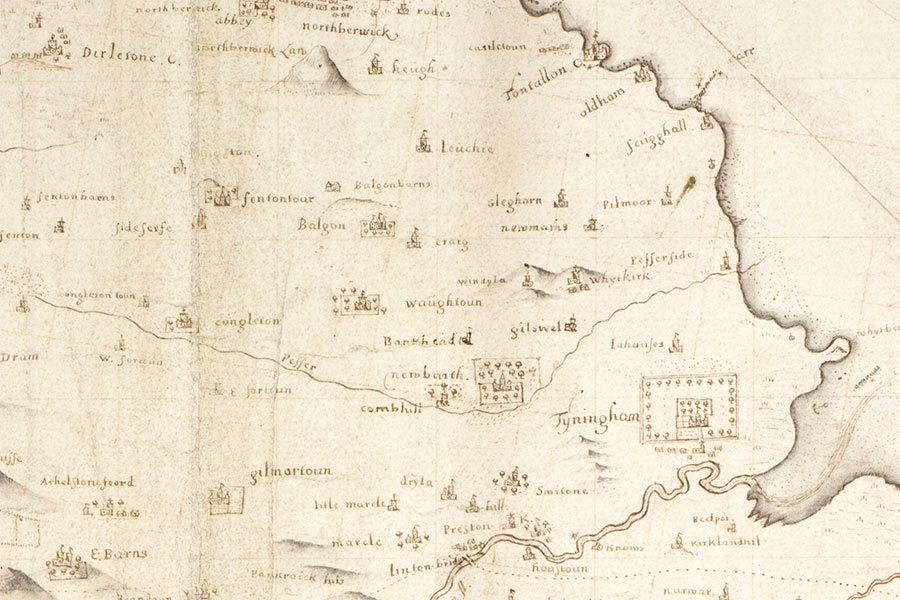
Joan Blaeu, Amsterdam, 1654map image courtesy of NLS
Either way in 1663 Sir John Nisbet (later Lord Dirleton) acquired “all and whole the lands and barony of Fenton, comprehending therein all and sundry the lands of Over-Sydserf, otherwise called Fenton tower, with the tower, fortalice, manor place thereof”. Whether or not he ever resided at Fenton is unclear as he soon built a new country house nearby at Archerfield. Fenton may have been occupied by a junior member of the family or perhaps estate workers.
John Adair, 1682map image courtesy of NLS
The tower was certainly habitable during the 18th century as Mary Yule, eldest daughter of George Yule of Gibslees, was born in it in 1753. She married Thomas Cleghorn of Weens or Weems / Wemyss in 1778. Fenton Tower may have been vacated by the end of the 18th century and was in ruins by the late 19th century. In 1906 the Simpson family bought the tower along with Sydserf farm.
In 1998 Ian Simpson, that Simpson’s great-grandson, and his childhood friend John Macaskill, now a banker in New York, decided to restore the tower, the ruins of which they had played in as children some 40 years earlier. The project was 2 years in the planning followed by 2 years of restoration, with Groves-Raines Architects, specialists in the restoration of historic buildings, appointed to oversee the work which cost around £2 million.
During 2000 and 2001 CFA Archaeology undertook archaeological investigations at the tower in order to record the ruins, look for buried remains and give their findings some context in relation to the known history of the tower.
Stone which had been robbed from the castle to build farm walls was reclaimed, and a nearby quarry which was the original source for the castle’s stone was reopened to provide new materials. The rebuilding and restoration took two years and was completed in 2002, with the castle now providing luxury accommodation. The tower also served as Archie the Inventor’s castle in the BBC series Balamory.


Alternative names for Fenton Tower
East Fenton; Easter Fenton; Eist Fentoun; Est Fentone; Est Fentoun; Ester Fenton; Estir Fenton; Estirfenton; Estyr Fenton; Fenton Tour; Fentone; Fentontour; Fentoun; Fentoun Tour; Fentoun-Tour; Fentoun-toure; Fentoune; Fentountour; Fentountoure; Over Sydeserf; Over Sydserf; Over Sydserfe; Over-Sydserf; Oversydserf; Ovir Syidsarff