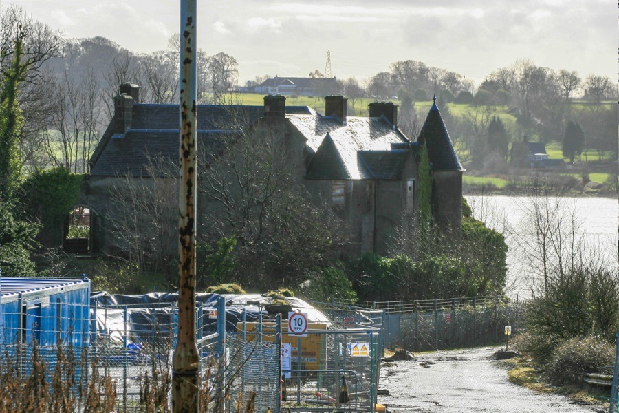
Dunglass Castle
Dunglass Castle is a ruined 14th century courtyard castle within which was built a 16th century fortified house, extended in the 19th century and now derelict.
Situated on a rocky promontory projecting from the north bank of the River Clyde it occupies a strategically important position observing and controlling passage along the river to and from the sea. This importance led to a Roman fort being built on the site, and it has been suggested that this rather than Kilpatrick may have been the terminal of the Antonine Wall.
Dunglass Castle is thought to have been built some time in the 14th century, although it’s early history isn’t known. However in 1439 it was granted to Sir John Colquhoun, later to be Comptroller of the Royal Household, Great Chamberlain of Scotland and governor of Dumbarton Castle, in 1439.
His grandfather, also Sir John Colquhoun, had also been the governor of Dumbarton Castle having been appointed in 1424. The lands around Dunglass formed the barony of Colquhoun, which had been in the possession of the Colquhoun family since early in the 13th century when Mael Domhnaich, the 3rd Earl of Lennox, granted the lands to Umfridus de Kilpatrick (modernised as Humphrey of Kilpatrick), probably around 1219. Humphrey subsequently adopted the surname Colquhoun.
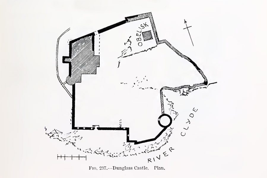
The earliest surviving part of the castle is the remains of a range built within the south wall of a courtyard. Thought to date to the 1470s, the south wall still stands to a height of two storeys and around 7 to 8 metres. At the centre of this wall is a sea gate giving access to the shoreline, directly above which the remains of corbelling can still be seen at the wall head.
At the north eastern corner of the courtyard, the rocky highest point on the site and now occupied by a 19th century monument to the steamship pioneer Henry Bell, there is thought to have been a tower. Probably built in the 14th or 15th centuries, no trace of it now remains. It may have been replaced or superseded by the south range.
David MacGibbon and Thomas Ross
Edinburgh, 1887
In 1489 James IV is said to have refortified Dunglass Castle during his siege of Dumbarton Castle.
Sir Humphrey Colquhoun built a new fortified house in the north-west corner of the site in 1590. Consisting of a three storey house arranged approximately north to south, it had a small bartizan projecting from the north-west corner. Below the corbels under this bartizan are carvings of the Colquhoun arms and a face in the shape of a shield, between which is the letter C.
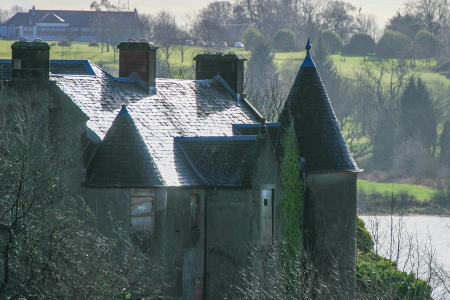
A wall extending from the north-east corner of the house, containing an arched entrance, and a relatively thin eastern wall and incorporated dovecot are also thought to date to a similar period, although the conical-roofed dovecot may be 17th century.
Colquhoun was beaten in a skirmish with the MacFarlanes of Arrochar in 1592 and fled to Bannachra Castle where he was killed by an archer who fired an arrow through a window.
Several sources state that during the 1630s the castle was garrisoned, that at the time of Cromwell a fort was built nearby, and that the castle blown up in 1640. However all of these things relate to the Dunglass Castle in East Lothian and not this one.
The castle’s condition deteriorated during the early 18th century and in 1735 the Commissioners of Supply ordered that it be partly partly demolished so that the stone could be used to restore Bowling’s quay nearby.
In 1738 it passed to the Edmonstone of Duntreath family in 1738, and in 1812 it was bought by Alexander Buchanan of Auchentorlie. He remodelled and extended the house in the 1830s with the addition of an east wing, and in the 1850s a circular turret was added to the south-west corner of the house.
From 1893 until 1899 the designer Talwin Morris owned and lived at Dunglass Castle, and carried out some work on the interiors. In 1899 he sold the property to his best friend Charles Macdonald, the lawyer brother of the artist Margaret Macdonald who would later marry Charles Rennie Mackintosh. Margaret and her mother moved in with Charles at this time. The same year Charles Macdonald commissioned Charles Rennie Mackintosh to redesign the interiors, in particular the drawing room and dining room. Rennie Mackintosh’s work here led to his commission to design the Hill House in Helensburgh.
Some time around 1910 to 1920 the south-east section of the courtyard wall extending from the dovecot fell into the river, but was later rebuilt. The house was occupied until the 1920s and subsequently was used as a stationary store.
Early in the 1920s land was reclaimed from the river to the west of the castle, and an oil terminal was built upon it by the then British Mexican Petroleum Co. Ltd. In the 1930s the oil terminal expanded onto partially reclaimed land to the east of the castle, leaving it surrounded by a massive industrial site.
The site was later bought by Esso but operations were closed down in 1997 and the process of decommissioning the plant began. Esso employed Simpson and Brown Architects to compile a report on the condition of the castle, and in 2000 they re-roofed the house and carried out consolidation work on the castle walls. The Rennie Mackintosh interiors, including a valuable fireplace and mantelpiece and a bookcase now in the National Museum in Edinburgh, have been removed. Historic Scotland granted Listed Building Consent in 2013 to repair the castle walls and make the house watertight.
As of March 2014 Dunglass Castle is still inaccessible to the public and under 24 hour surveillance.


Alternative names for Dunglass Castle
Dunglas; Dunglass House