skip to main content
Menu
  • Blog
    • Art & design
    • Castles
    • Cycling
    • Edinburgh
    • Edinburgh Festival
    • Food & drink
    • General
    • History
    • Music
    • Sport
    • Walking
    • Whisky
    • Wildlife
  • Castles
    • Glossary
    • Mottes
    • Stay in a castle
    • Castle blog posts
    • Alphabetical list of castles
    • Castles divided by county
    • Photos of castles
    • Castles we've visited
  • History
    • Castles
    • Ancient history
      • barrows
      • brochs
      • cairns
      • caves
      • chambered cairns
      • cists
      • crannogs
      • cursus monuments
      • forts
      • henges
      • rock art
      • sacred sites
      • souterrains
      • standing stones
      • stone circles
    • Pictish history
      • Pictish stones
      • Pictish sites
      • Pictish placenames
    • Clans
      • Surnames
      • Trace your ancestors
      • Tartan
    • Trace your ancestors
  • Culture
    • Music
      • Bands & musicians
      • Music links
    • Film
    • Television
    • Placenames
      • Pictish placenames
  • Eat
  • Drink
    • Scottish beer
    • Scottish gin
    • Scottish vodka
  • Stay
  • Travel guide
    • City guides
    • Car hire
    • Airports
  • Walking
    • Munros
    • West Highland Way
  • Photos
    • ancient sites
      • Dark Age sites
      • megalithic sites
      • other carved stones
      • Pictish sites
      • Roman sites
    • buildings
    • miscellaneous
    • places in Scotland
  • Offers
  • Home
  • history
  • castles

Durnock


Durnock was a tower extant in the 16th century but nothing of it now remains and its exact location is unclear.

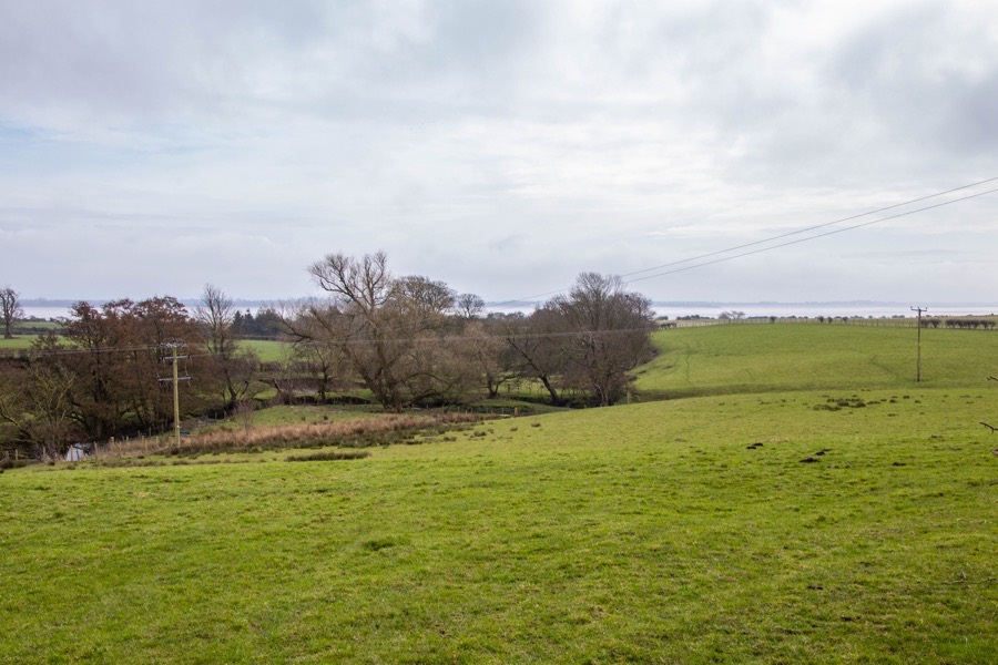
On the historical main route from Gretna to Annan the village of Dornock stands on rising ground to the north of the Dornock Burn, which flows down through marshy land to the Solway Firth. There was an old harbour on the coast not far from the village and fisheries which were historically considered important. Close by the Battle of Dornock was fought between English invaders under William of Lochmaben, Sir Ralph Dacre and Sir Anthony Lucy and a much smaller Scottish force under Sir William Douglas, Lord of Liddesdale in March 1333.

The village’s church is built just to the north of the site of the pre-Reformation St. Marjory’s church, the patronage of which was held by the Earls of Douglas by the early 15th century. In 1411 Simon of Carruthers received the church’s patronage and a grant of the “lands of Middilby and Dronnok” from Archibald Douglas, Earl of Douglas.

James II granted to John Carruthers of Mouswald, possibly Simon’s nephew, “the lands of Mousfald, Loganetenement, Medilby, Dronnok, Ellirbek, Hatilland Hill, Cummertries, Hoddome, Tunnergath, Hallthis, Cumlungand, Hultvhate, Stanrase and Wamfray” in 1452.

Following the Scottish defeat at the Battle of Flodden in 1513 English raiding parties entered the south of Scotland and laid waste to the countryside. Lord Dacre reported one such incursion in May 1514:

And upon the West Marchies of Scotland, I haif burnt and distroyed the townshipps of Annand, Dronok, Dronokwod, Tordoff, Fyshegewghe, Stokes, Estrige, Ryelande, Blawetwood, Foulsyke, Westhill, Berghe, Rigge, Stapilton, Wodhall, Raynpatrike, Woddishill, Overbrotts, Nethirbrotts, Elistrige, Caluertsholme, Beltemmount, Hole, Kirkpatrike, Hyrdhill, Mossesyde, Stakehughe, Bromeholme, Walghopp, Walghopdale, Baggraye, Murtholme, Langhane, Grymesley, and the Watter of Esk, fro Stabulgorton downe to Cannonby, beyng vi myle in lienth. Where as there was, in all tymes passed, ccccth pleughes, and above; whiche er now clerely waisted, and noo man duelling in any of them, at this daye; saue oonly in the Towrys of Annand, Stephill, and Walghopp.The History of Scotland, Volume II
John Pinkerton, London, 1797

In 1516 James V confirmed the “seven merk lands of Dronok” to Simon Carruthers and his wife, Katherine Carlile, and the lands subsequently passed through her to the Carlyles of Torthorwald. In 1529 Michael Carlile, the brother and heir of the late James, Lord Carlile, was granted a charter which included “the lands and mill of Durnock, with the advowson of the church of Durnock”.

The lands of Dronok seem to have later returned to the Carruthers family as they were owned by Simon Carruthers of Mouswald when he married Agnes, daughter of Cuthbert Murray of Cockpool, in 1538. Durnock was burned once again in 1543, by Thomas, Lord Wharton, the victor at the Battle of Solway Moss the previous year:

Also we brent Tordof, Dronoke, Blayt, Blaytwod, West hilles, Staillis, Stokes and others howses and steydes, beuildinges, and that litle corn they had was brent at all thes towns aforesaid.The Hamilton Papers, Volume II
Joseph Bain, Edinburgh, 1890

Carruthers died in 1548 and was succeeded by his daughters Janet and Marion between who his lands were divided. Janet Carruthers seems to have granted her part of the lands of Dronok to Sir James Douglas of Drumlanrig in 1562, while in 1564 Marion appears to have sold her part to Charles Murray of Cockpool.

Douglas had plenty of other properties and it may be that Durnock fell out of use at this time, perhaps having been damaged beyond repair during English attacks, although this is speculation on my part. The tower of Dundronok is marked on Lord Burghley’s map of 1590 but with few clues as to its specific location beyond its relative proximity to Torduff Castle.

Douglas transferred the lands to his son, also James, along with barony of Mouswald in 1608. In the 1640s the lands were in the possession of Archibald Douglas of Dornock and by 1681 were owned by William Douglas, 1st Duke of Queensberry, who was described variously as the “laird of Dornock” and “Lord Douglas of Kinmont, Middlebie and Dornock”.

The tower of Durnock is marked on Blaeu’s map of 1654 to the west of the Dornock Burn and north-east of Durnock Kirk.

Durnock

Annandiae praefectura, Vulgo, The Stewartrie of Annandail
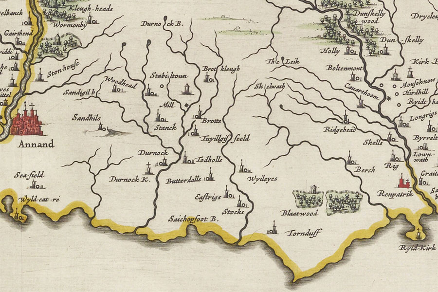
Joan Blaeu, Amsterdam, 1654map image courtesy of NLS

Around 1700 a new house, Dornock House, was built in the classical style on the south edge of the village. In 1718 James Douglas of Dornock bought lands from Sarah Irving and William Knox that her uncle, William Irving of Kirkconnel, had owned.

Dornock House was occupied in 1768 by John Douglas of Dornock. James Douglas of Dornock married his cousin, Philadelphia, only daughter of Sir John Johnstone of Westerhall, in the mid-18th century. The Douglas Dukes of Queensberry, and later the Douglas Scott Dukes of Buccleuch are said to have held Dornock into the 19th century although I haven’t been able to find a definitive reference to this.

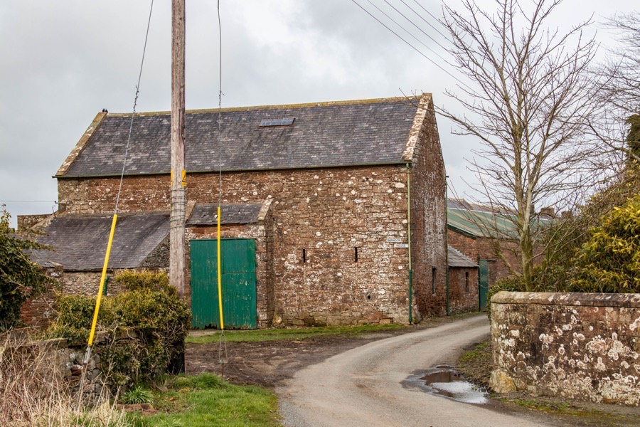
Dornock House was later extended as part of a complex of farm buildings, and the location of the tower has been lost. Historic Environment Scotland propose a site to the south of and overlooked by the village, although this doesn’t appear to be based on anything other than the aforementioned 16th and 17th century map references. The Ordnance Survey map of Annan and Dornock, published in 1899, shows a well to the south of the church partly enclosed by a bend in the Dornock Burn although I haven’t been able to ascertain the age of the well.

The lower-lying site to the south of the village may not seem so likely a castle site today, however if the Dornock Burn was navigable at that time then it may make more sense. The higher ground now occupied by Dornock House, close to the site of the medieval church, may however be a more likely location, with remnants of the tower perhaps even being incorporated into Dornock House or neighbouring farm buildings.

Durnock

stay in a castle
  • advertisement

Alternative names for Durnock

Dornock; Dornock House; Dronnok; Dronok; Dronoke; Drounok; Drunnok; Dundronok; Durno; Durnok

Clans associated with Durnock

Carruthers

Douglas

Surnames associated with Durnock

Carruthers

Douglas

Where is Durnock?

Durnock is in the parish of Dornock and the county of Dumfriesshire.

Grid reference:NY 231 659

Lat / long:54.98174,-3.2031345

Bing Maps | Google Maps | Historic maps (NLS) | OpenStreetMap | Ordnance Survey | PastMap | Streetmap | Wikimapia

OS Map for Durnock

OS map 314
Solway Firth (Wigton & Silloth)
OS Explorer map 314


OS map 323
Eskdale & Castle O’er Forest (Langholm, Canonbie & Gretna Green)
OS Explorer map 323


  • advertisement

Directions to Durnock

Enter a starting point

  • advertisement

Weather at Durnock

5°C
max 5°C / min 5°C
9km/h WSW
1033mb
80%
96%
08:12 16:37

Overcast clouds
Weather observed at Annan at 12:20
  • advertisement

References (books)

Caledonia (Volume 3)
George Chalmers
Paisley, 1888
Chronicon de Lanercost
Maitland Club
Edinburgh, 1839
History of the Johnstones
C.L. Johnstone
Edinburgh, 1909
Proceedings of the Society of Antiquaries of Scotland (Volume 23)
Various
Edinburgh, 1889
The Castles of Scotland
Martin Coventry
Prestongrange, 2015
The History Of Scotland (Volume II)
John Pinkerton
London, 1797
The manuscripts of His Grace the Duke of Buccleuch and Queensberry, KG, KT (Volume I)
HMSO
London, 1897
The Parishes of Medieval Scotland
Ian B. Cowan
Edinburgh, 1967
The Register of the Great Seal of Scotland A.D. 1513-1546
James Balfour Paul
Edinburgh, 1883
The Register of the Great Seal of Scotland A.D. 1546-1580
John Maitland Thomson
Edinburgh, 1886

References (websites)

Canmore

Castles near Durnock

Torduff (site of)

3.0km away

Stapleton Tower

3.0km away

Annan Castle (site of)

4.0km away

Westhills (site of)

4.1km away

Warmanbie (site of)

4.7km away

Blawst (site of)

5.4km away

Dumbretton (site of)

5.6km away

Dunskellie Castle (site of)

5.7km away

Newbie Castle

5.8km away
more castles....
  • advertisement

Ancient sites near Durnock

Cadgill cursus

12.2km away

McCulloch's Castle fort

24.8km away

Trailflat cursus

26.3km away

Lochbrow cursus

27.0km away

Curriestanes cursus

28.6km away

Holm cursus

30.7km away

Holywood South cursus

31.3km away

Holywood North cursus

31.4km away

Twelve Apostles stone circle

31.4km away
more ancient sites....
  • advertisement
  • Ancestry advert

Pictish stones near Durnock

Borthwick Mains Class I symbol stone

52.4km away

Trusty's Hill Class I rock carving

64.7km away

Eggerness Class I rock carving

76.4km away

Abernethy No. 2 Class III symbol stone

107.4km away

Abernethy No. 4 Class III cross shaft

107.4km away

Princes Street Gardens Class I symbol stone

107.6km away

Hawkhill Class III cross-slab

131.0km away

Court Cave Class I rock carving

131.4km away

Doo Cave Class I rock carving

131.5km away
more Pictish stones....
  • advertisement
  • advertisement

Pictish sites near Durnock

Whitecleugh silver chain

68.4km away

Todholes (possible) silver chain

82.0km away

Borland silver chain

82.0km away

Whitlaw silver chain

86.2km away

Hoardweel silver chain

109.5km away

Haddington silver chain

111.3km away

Traprain Law silver chain

114.5km away

Norrie's Law hoard

142.5km away

Dunnicaer fort

228.4km away
more Pictish sites....

Accommodation near Durnock

Days Inn Gretna Green
hotelGretna Green
8.2km away
Bella Vista
self-catering apartmentPowfoot
8.2km away
Gables Hotel
hotelGretna Green
8.4km away
Powfoot Golf Hotel
hotelPowfoot
8.4km away
Kirkcroft Guest House
bed and breakfastGretna Green
9.1km away
Gretna Hall Hotel
hotelGretna Green
9.1km away
Solway Lodge Hotel
hotelGretna
9.1km away
Rhone Villa
bed and breakfastGretna Green
9.2km away
Smiths At Gretna Green Classic
hotelGretna Green
9.3km away
Hazeldene Hotel
hotelGretna Green
9.4km away

Accommodation search

(leave blank to view all)
Accommodation type
bed and breakfasts
campsites
castles
holiday parks
hostels
hotels
self-catering apartments
self-catering cottages
self-catering lodges
spas
more accommodation....

Cafés, restaurants & bars near Durnock

Kirkconnel Hall Hotel
hotel, restaurant, barEcclefechan
10.1km away
Hetland Hall Hotel
hotel, restaurant, barCarrutherstown
15.0km away
The Cross Keys Hotel, Canonbie
hotel, barCanonbie
19.0km away
Best Western Dryfesdale Country House Hotel
hotel, restaurant, barLockerbie
20.3km away
Premier Inn Dumfries
hotel, restaurantDumfries
24.7km away
Aston Hotel Dumfries
hotel, restaurant, barDumfries
26.1km away
Cavens Country House Hotel
hotel, restaurantDumfries
26.4km away
Best Western Station Hotel
hotel, restaurant, barDumfries
27.6km away
Friars Carse Country House Hotel
hotel, restaurantAuldgirth
36.0km away
Annandale Arms Hotel
hotel, restaurant, barMoffat
42.0km away
more food.... / more drink....

Related pages

Dirleton Castle in East Lothian
Garden of Cosmic Speculation plus castles
Inveraray Castle and standing stone
A doocot, a castle and a beach in East Lothian
A pair of castles on the River Tweed
Dunbar harbour and castle
Published on the 21st of December 2011 at 12:11 am. Updated on the 24th of January 2021 at 6:54 pm.

Leave a comment

back to the top of the page

Connect with us

Like us on Facebook

Receive our newsletter

Follow us on Twitter

Tweets by Stravaig_Aboot
  • Ancestry advert

Quick links

Stay in a Scottish castle
Edinburgh Festival accommodation
Hotels in Scotland
Car hire in Scotland
Places to eat and drink in Scotland
Castles in Scotland
Trace your Scottish ancestors
Scottish clans
Standing stones in Scotland
The Picts
Pictish symbol stones
Pictish placenames
Scottish bands and musicians
Scottish films
Scottish TV shows
West Highland Way

About

Andy Sweet above Fast Castle

Stravaiging around Scotland is written, photographed and researched by Andy Sweet.
read more....

Cookies

To make this site work properly we use cookies to store information on your computer. Click here to read more.
© 2003 - 2023 Andy Sweet / Stravaiging around Scotland. Powered by WordPress. Hosted by Tsohost.