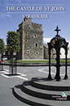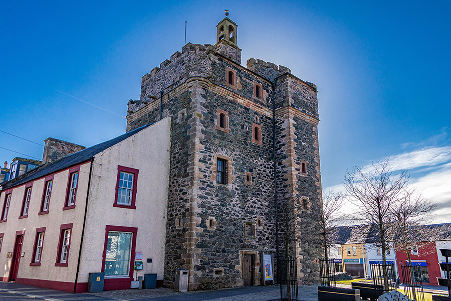
Castle of St. John
The Castle of St. John, or Stranraer Castle, is an early 16th century castle in Stranraer which may have earlier origins.
In the 13th century the lands around Stranraer seem to have been owned by the MacDouall family, who traced their descent from the Lords of Galloway, although it has also been suggested that they were owned by the Knights Hospitallers of the Order of Saint John. The MacDoualls were supporters of the Comyns against Robert the Bruce and in the pay of Edward I of England.
Early in the 14th century Robert the Bruce gave to Fergus de de Mandeville (also spelt as Mondewilla or Mundwell) the half lands of Stranreuer or Stranraer which had belonged to Sir Dungal MacDouall. In 1307 MacDouall had repelled an invasion of Galloway led by two of Bruce’s brothers, Thomas and Alexander, who were captured and subsequently executed in Carlisle.
By 1484 the Adair family had acquired lands at Stranraer and built a chapel there dedicated to St. John. The Adairs originally came from Ireland in the 13th century and became one of the most powerful families in Wigtownshire. The chapel was a dependency of Inch parish church and the area became known as St. John’s Croft or simply Chappell or Chapel. Stranraer was in Leswalt parish and the parish boundary was what became known as the Town Burn, which now runs in a tunnel under Castle Square.
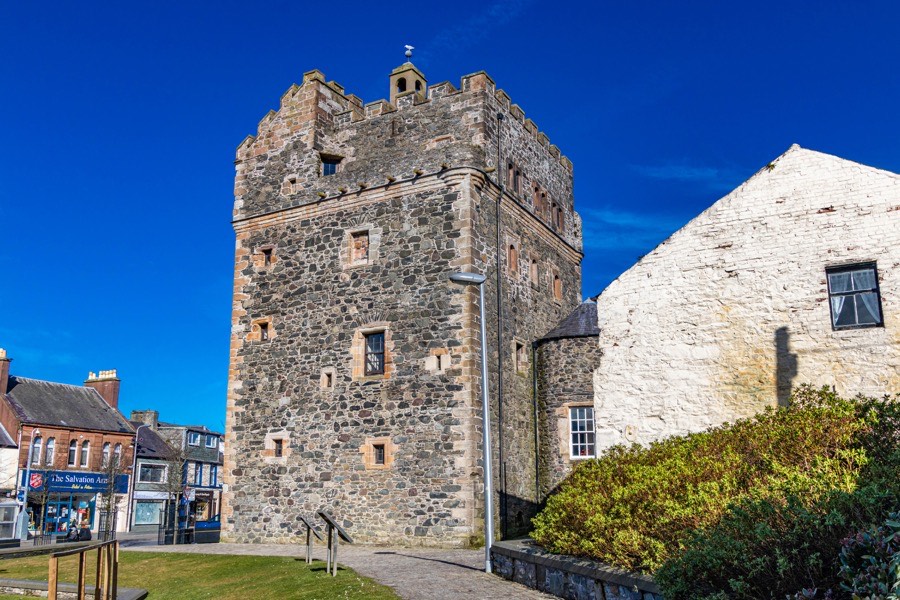
A castle was built at Chappell in 1510 or 1511, usually attributed to Ninian Adair of Kilhilt however it may have been his father, William Adair of Kilhilt. The castle may have been built on the site of earlier building, indicated by various stylistic features usually found in castles earlier than the 16th century.
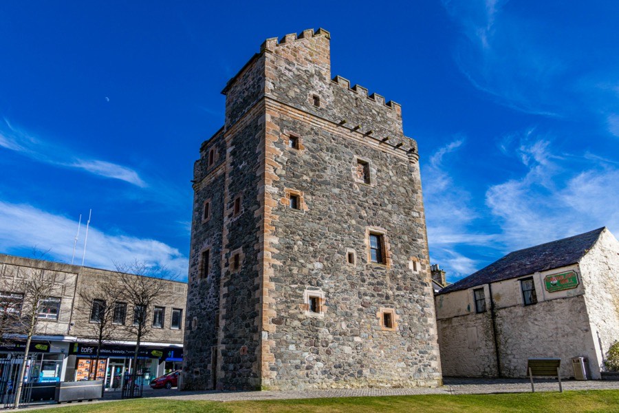
The castle consists of three storeys plus an attic and the main block is rectangular in plan, aligned approximately east to west measuring around 10.7m east to west by around 8.5m north to south. A stair tower projects around 1.5m from the north-west corner of the north wall, giving the castle an L-plan, and is around 3.6m wide.
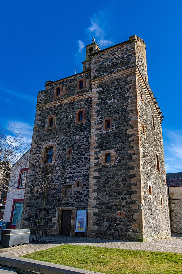
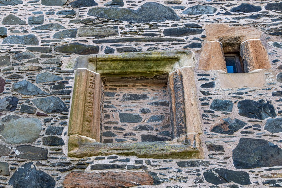
The walls are around 1.6m thick and rubble-built from local dark whinstone with lighter sandstone dressings quarried in central Ayrshire. The entrance is via a roll-moulded doorway on the north side, to the east of the stair tower, with a splayed gunloop to its left.
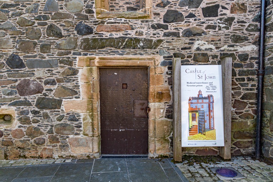
Above the doorway is an empty niche would have held a heraldic panel. The edges of the niche are carved with a worn inscription which is said to contain the names of Adair and Kennedy commemorating a marriage between those families.
The entrance led into a lobby and narrow corridor, within the thickness of the north wall, with a flat slabbed ceiling. A doorway straight ahead led into one of two chambers located on the barrel-vaulted ground floor. This eastern chamber features a gunloop on both the north and south walls and has joist holes indicating that there was a wooden entresol. The vaulting runs north to south and high on the east wall is a small blocked window. The western chamber’s vaulting runs at ninety degrees to its neighbour’s, that is east to west, and it features a recess in the west wall. This recess seems to have been knocked through at a later date, perhaps in the 18th century, to provide access to a neighbouring building. Both chambers originally had cobbled floors.
Continuing along the corridor to the west leads to the spiral staircase which gave access to all floors. At the bottom of the staircase is a blocked entrance to what would once have been a servants’ stair rising up to the first floor within the thickness of the west wall. Just before reaching first floor level a doorway leads to a narrow room off the left of the stair and within the thickness of the north wall. Recesses in the south wall of this room are thought to have house cupboards in which valuables may have been stored. This kind of intramural chamber is more common in towers of the fifteenth century and may represent the remains of an earlier building.
On the first floor is the barrel-vaulted Great Hall, although the vault was apparently added in the 19th century when the original timber ceiling was removed. To the right of the staircase entrance in the north wall is a large fireplace, later reduced in width with the addition of masonry sections. Behind the fireplace within the thickness of the wall is a small chamber which is thought to have been a pit prison, accessed from the floor above via a trapdoor.
At the east end of the north wall is a large window recess which would have had bench seats on either side of it. An opening in the west side of this recess leads into what was the pit prison which was later repurposed as a small kitchen with the installation of slop sink at its west end. Within the west wall of the Great Hall is an intramural garderobe accessed from a window recess and at the south end of the wall is an entrance to the blocked servants’ staircase.
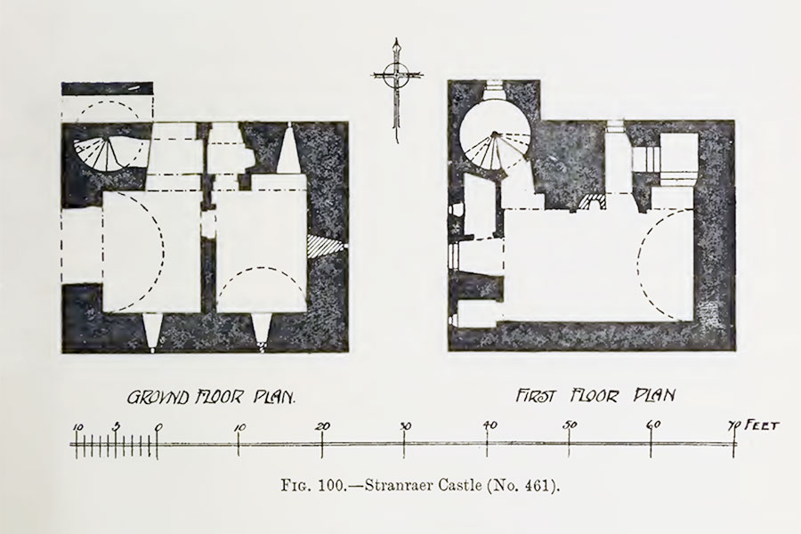
The original layout of second floor is unclear due to extensive remodelling in the 19th century, however it is likely to have consisted of two bedroom chambers accessed via a narrow corridor to the north. Each chamber had a cupboard at the south end of their external walls and a window at the north end, all now blocked.
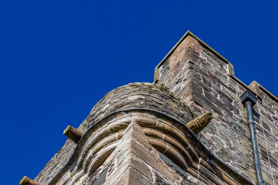
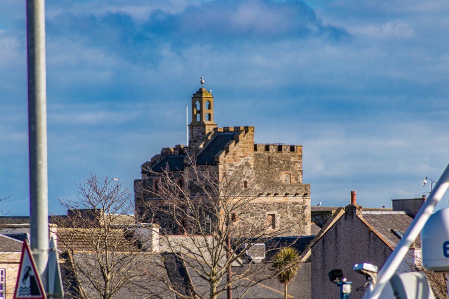
The third floor was also altered significantly in the 19th century however there are clues as to the original layout. A caphouse above the staircase occupied the north-west corner of the tower while there were bartisans at each of the other corners. A parapet walk supported by corbels is likely to have extended around three sides of the tower with a garret level structure within housing servants’ quarters.
The castle would almost certainly have been surrounded by a courtyard wall with ancillary buildings but no trace of these remain.
William was killed at the Battle of Flodden in 1513 and was succeeded by, Ninian Adair of Kilhilt, variously described as his son or grandson. Ninian was married to Katherine Agnew, daughter of Patrick Agnew, Sheriff of Galloway and seems to have died by 1520. In 1520 or 1521 Ninian’s son, William, was underage and so some of his inheritance was placed in the care of Gilbert Kennedy, 2nd Earl of Cassilis. Later William would marry the 2nd Earl’s daughter, Helen.
In 1549 Robert Johnston of Newton, brother of Gilbert Johnston of Ochterlure and Aryewlane, sold St. John’s Croft, land close to the castle, to his niece Agnes’ husband, James Kennedy, said to be a son of Gilbert, 3rd Earl of Cassilis, and a Hew Kennedy of Chappell is on record in 1571.
The younger William was succeeded by his son, Ninian. Ninian’s son, also named William, married Rosina MacClellan of Galston, sister of Sir Robert McClellan of MacLellan’s Castle, in 1580 and in the 1590s Ninian’s daughter, Elizabeth, married John Kennedy of Greenan, Creichan and Balneil, natural son of the 3rd Earl of Cassilis. Their son, Gilbert Kennedy of Aryewlane, would marry Helen Adair, grand-daughter of William Adair and Helen Kennedy, around 1603, so cementing the Adairs’ connection with the Earls of Cassilis.
In 1595 the Clachane of Stranrawer was included in a barony for Ninian Adair of Kilhilt and in 1596 Stranraer was created a burgh of barony under Ninian’s superiority. The barony comprised of “Saint John’s Croft, extending to six acres from the burn which comes from the Loch of Chappell to the Loch of Lochryan and the lands of Airds on the east. The Tower, fortalice, manor-place, and yards of Chappell, on the west. The watergang which runs to the Mill of Chappell on the south, and the Loch of Lochryan on the north. Reserving to Elizabeth Kennedy, heretrix of the said Croft, the Tower, Fortalice, Manor-Place, yards, and orchards of Chappell.”
The castle is said to have been attacked in 1599 by Alexander Gordon of Hills and Robert Gordon of Glennis, however I have only found one reference to this and Hills was a Maxwell property at that time. It may be that the story has become confused over the centuries and actually refers to somewhere else. If the castle was in fact attacked it may however have prompted remodelling work which was carried out around 1600.
At that time the garret level was remodelled and extended out to the north and south edges of the parapet, leaving isolated sections of wall walk to the east and west. The west wall walk was accessed via a small spiral stair leading off the main staircase while its eastern counterpart was accessed via a doorway at the end of the corridor running along the edge of the north wall, now later converted into a window. This smaller staircase also led up to an attic room at the top of the caphouse but was later blocked. It may be that the internal remodelling of the Great Hall dates to the same period, the changes intended to better reflect the Adairs’ increased wealth and standing.
Ninian died in 1608 and is said to have been succeeded by his son, William, despite the burgh of barony document reserving the tower of Chappell to Elizabeth. It’s possible that William inherited his father’s other estates, including Kilhilt, but that the castle in Stranraer went to his sister.
In 1617 Stranraer became a royal burgh when the castle was again seemingly reserved to Elizabeth and her husband. William died in 1626 having moved to Ballymadoss in County Antrim, Ireland, presumably as part of the Plantation of Ulster, and was succeeded by eldest son, Sir Robert Adair of Kilhilt. Sir Robert’s two sons, William and Archibald, both moved to Ireland and so his daughter Isobel seems to have inherited Kilhilt and presumably also the castle in Stranraer.
Isobel married Patrick Macdowall of Logan around 1649 and died in 1678. It is said that Sir John Dalrymple of Stair bought the castle in 1677 to serve as the town house of the Dalrymples but I wonder if this was connected to Isobel’s death in some way. It may also have become confused with Sir John’s purchase of Castle Kennedy in 1677.
Sir John supported the Covenanters and in 1682 John Graham of Claverhouse, who had been appointed military commander of the area in 1678, quartered his troops on Dalrymple’s property and lodged in the castle. It seems to have continued in use as a military garrison for government troops and in 1685 it was attacked by a band of Covenanters. The perpetrators were later taken to the castle to be interrogated by the Colin Lindsay, 3rd Earl of Balcarres, and Claverhouse.
At Claverhouse‘s instigation Sir John was arrested and imprisoned in 1684 and wasn’t released until November 1685, some time after which the castle resumed service as the Dalrymples’ town house. He was eventually rehabilitated however, despite his involvement in the Massacre of Glencoe, and in 1703 was created 1st Earl of Stair.
During the 18th century a house was built against the east wall of the tower and the windows on that side were blocked at this time. Another building was built up against the south wall. Stranraer had increased rapidly in size and the area around the tower was becoming increasingly built up. In 1684 there were only 279 people over the age of 12 in the town however by the end of the 18th century there were more than two thousand inhabitants.
In the mid-18th century the Earl of Stair moved to a new house in Stranraer, supposedly where the George Hotel is now, however the fate of the castle is unknown. By the early 19th century the castle was empty and in 1815 it was bought by the town council for £340 with the intention to use it as a courtroom and jail. In 1820 the architect Robert Wallace criticised plans for the conversion which he had been sent and proposed his own, however designs by the Glasgow architect Kenneth Mathieson were accepted with an estimated cost of £600 and the extensive remodelling was carried out in 1820 and 1821.
The timber ceiling of the first floor was removed and replaced with a stone vault, the Great Hall being converted into a courtroom. Significant changes were made to the second floor which was divided into three cells using red sandstone from Dumfriesshire and an iron gate was added to the entrance to the corridor. The east and middle cells were accessed via the corridor while the west cell was accessed directly from the staircase.
On the third floor the 17th century addition was remodelled to contain two debtors’ cells and an iron gate added to the entrance to its corridor. The 17th century gable roof was removed and replaced with a flat roof which was used as an exercise yard for the prisoners, accessed via the spiral staircase. A belfry was added to the top of the original medieval chimney.
Conditions in the castle prison were seemingly bad and in 1847 a new prison was built on Lewis Street, with the castle being used for a short time in the 1850s as a police station. By 1875 the castle was so closely “surrounded by other buildings that its antique baronial appearance is completely hidden”, being hemmed in by shops and other buildings with a narrow lane known as Castle Court leading to the entrance.
Some of the prison cells were apparently still in occasional use as late as 1907 but by 1912 the castle was used mainly as a store for nearby shops. During the Second World War it was used as an Air Raid Precautions base. In the 1960s and 1970s various buildings were cleared away from around the tower giving the castle a renewed prominence in the town.
In 1979 archaeological investigations were carried out ahead of consolidation work, revealing cobbled floors in the cellars and an open drain in the west cellar. On the first floor two blocked-up mural passages were found along with the former pit prison behind fireplace.
Between 1988 and 1990 further archaeological investigations were carried out ahead of the castle’s refurbishment. The floor of the stair tower was excavated and the original floor level was discovered 0.2m down. A small section, around 0.7m by 0.5m, of the Great Hall’s flooring was removed at the centre of room which revealed pieces of oyster shell and a bird bone. The chamber behind the fireplace was cleared of around 0.9m of earth and bird droppings which revealed two stone steps. The wooden floor in front of this chamber was removed along with 0.3m of debris and a modern cement step, revealing the original stone slab floor.
Following its renovation the castle was opened in 1990 as a museum and visitor centre.


Alternative names for Castle of St. John
Castell of Chappell; Castle Kennedy; Castle of Chapel; Castle of Saint John; Castle of St John; Castle of St. John; Chapel; Chappel; Chappell; Kennedy's Castle; Place of St John; Place of St. John; St John's Castle; St Johns Castle; St. John's Castle; St. Johns Castle; Stranraer Castle; The Chapel