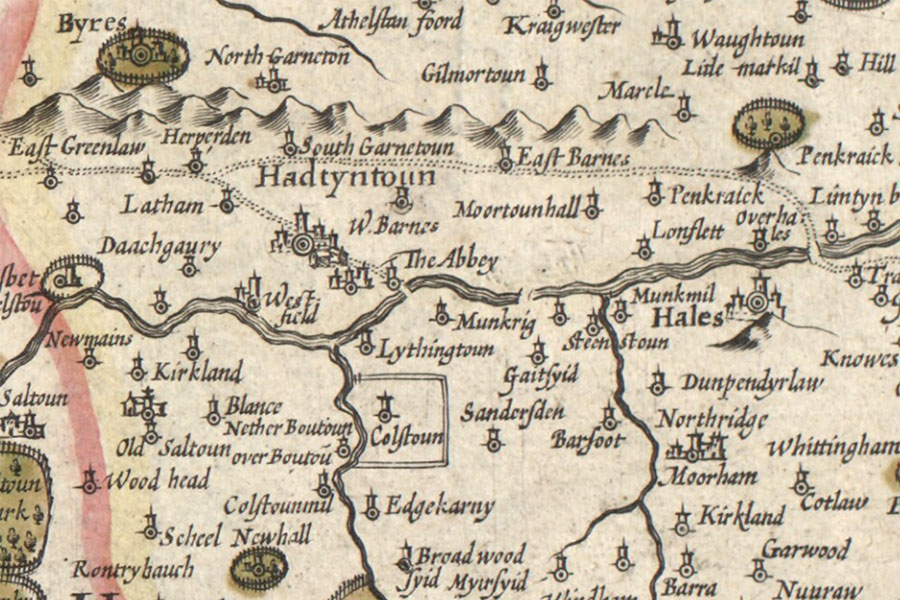
Byres Castle
Hendrik Hondius, Amsterdam, 1630map image courtesy of NLS
Byres Castle is a small ruined castle which was for centuries the seat of the Lords Lindsay of the Byres.
It may possibly be more accurately described as a bastle rather than a castle. Whatever its true classification, it’s a small but substantial structure measuring around 6.3m long by 5.2m wide, with walls 0.7m thick.
Now in ruins, it consists of two storeys. The ground floor level is vaulted and features narrow slit windows in the north-east and south-west walls, with a larger square window in the south-east wall. Access is provided by a doorway in the south-west wall.
The first floor features a fireplace but is now unroofed.
The existence of an earlier castle is suggested by the fact that the title of Lord Lindsay of the Byres was created in 1445 for Sir John Lindsay. His daughter, Margaret Lindsay, was married to Henry Wardlaw and by 1477 they owned the barony of Inchgall in Fife.
Sir John died in 1482 and was succeeded by David Lindsay, who died in 1490, then in turn by John Lindsay. The 3rd Lord Lindsay of the Byres married Margaret Baillie, daughter of Sir William Baillie of Lamington, and died in 1497, being succeeded by Patrick Lindsay.
The Lindsays seem to have had some interest in the lands of Midhope in West Lothian. In 1517 a Marion Livingston and Margaret Roull were recorded as assignees to Margaret, Lady Lindsay of the Byres, and a letter of reversion from 1523 indicates that Margaret Roull had been given the lands of Medhope for the “sum of £100 Scots, being half the value of the marriage of John Livingstone of Manerstoun” but offered to resign them if the £100 was repaid (with expenses).
Patrick Lindsay, 4th Lord Lindsay of the Byres, died in 1526 and was succeeded by his grandson, John Lindsay, son of John Lindsay of Pitcruvy, Master of Lindsay. In 1537 Sir James Hamilton of Finnart received a grant of half the lands of Medop, half the lands of Mannerstoun and half the mill of Abercorne from Elizabeth Martyne, Lady of Falscastell, who held the lands from the 5th Lord Lindsay of the Byres.
In 1538 James V confirmed a charter to Sir James Hamilton of Finnart by John Lindsay of the lands, tower, fortalice, mill and fisheries of Meidhoip, and the lands of Manerstoun. Hamilton was convicted of treason and executed in 1540 and the same year the King confirmed a new charter to Lord Lindsay of various lands including Medope.
The Hamiltons seemed to have continued to hold Midhope from Lindsay of the Byres however as in 1545 Andrew Hamilton of Meddop was Provost of Glasgow. In 1546 Mary, Queen of Scots, granted to Patrick Lindsay, son and heir of the 5th Lord Lindsay of the Byres, his father’s lands including Meidhope.
The present structure is thought to date back to the 16th century. During the Rough Wooing the English are said to have dismantled Byres in 1548, and it was probably rebuilt in its current form following the English departure from Haddington in 1549.
It has been speculated that some of the stone from Byres was used to build Garleton Castle nearby in the 16th century.
In 1587 James VI confirmed the 6th Lord Lindsay of the Byres in various lands which belonged to his late father, including Medhop. The 6th Lord Lindsay died in 1589 and in 1591 his son, James Lindsay, 7th Lord Lindsay of the Byres, a gentleman of James VI’s bedchamber, had a ratification of various lands in the Lothians, including the lands of Midhope, from the King.
The 7th Lord Lindsay was forfeited in 1596 for his involvement in a riot at the Tolbooth kirk in Edinburgh however in 1603 James VI confirmed John Lindsay, 8th Lord Lindsay of the Byres, in various lands including Medop. Later that year the King granted the barony of Abercorn, which the 8th Lord Lindsay had resigned to him, to James Hamilton, creating him the 1st Earl of Abercorn.
Jean Lindsay, grand-daughter of Patrick Lindsay, 4th Lord Lindsay of the Byres and widow of John Melville of Carnbee, married John Anstruther, minister of Kilrenny in Fife and son of John Anstruther of Anstruther.


Alternative names for Byres Castle
Byres Tower; Byris; The Byres