West Cowden Farm
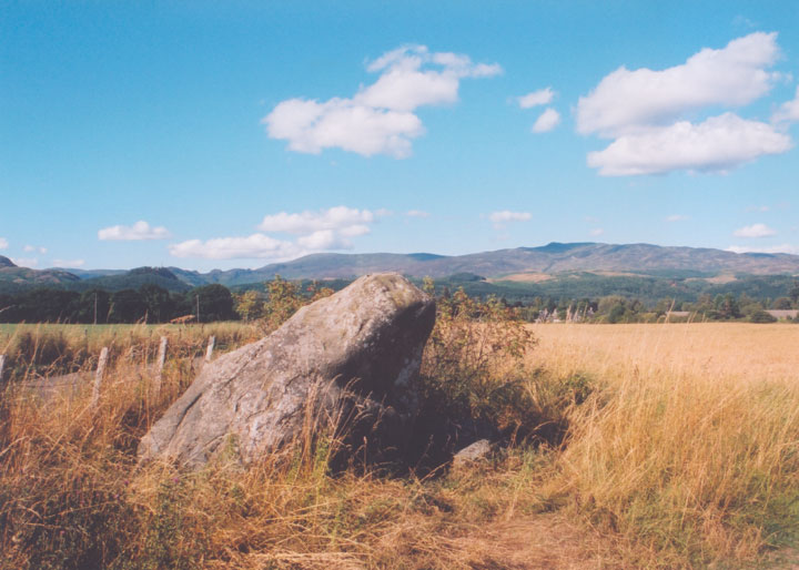
There are three stones here in a line, almost certainly not in their original positions. The largest, known as the Roman Stone, leans sharply to the east but still manages a vertical height of around 1.90m. Beside it is a block of whinstone about 0.50m thick by 1.30m long by by 0.85m wide and a now earthfast stone decorated with 22 cupmarks.


Alternative names for West Cowden Farm
Dalginross; Roman Stone
Where is West Cowden Farm?
West Cowden Farm is in the parish of Comrie and the county of Perthshire.
Grid reference: NN 7744 2064
Lat / long: 56.362198, -3.985317
OS Map for West Cowden Farm

Crieff, Comrie & Glen Artney (Strathearn & Auchterarder)
OS Explorer map OL47
Buy from Ordnance Survey
OS Explorer map OL47
Buy from Ordnance Survey
Directions to West Cowden Farm
Enter a starting point
Get directions

Weather at West Cowden Farm
12°C
max 13°C / min 10°C
max 13°C / min 10°C
4km/h N
1029mb
54%
100%
04:55 19:33
1029mb
54%
100%
04:55 19:33
Overcast clouds
Weather observed at Comrie at 14:04
References (books)

References (websites)
Ancient sites near West Cowden Farm
Castles near West Cowden Farm
Pictish stones near West Cowden Farm

Pictish sites near West Cowden Farm
Accommodation near West Cowden Farm
Comrie Croft SYHA Hostel
3.6km away
James Cottage Guest House
8.5km away
The Four Seasons Hotel
8.7km away
Drummond Hotel
8.8km away
Knock Castle Hotel & Spa
8.8km away
Crieff Hydro self-catering cottages and chalets
9.2km away
Crieff Hydro Hotel and Leisure Resort
9.3km away
Merlindale
9.4km away
Galvelbeg House
9.5km away
Murraypark Hotel
9.6km away
Accommodation search
Cafés, restaurants & bars near West Cowden Farm
Torlum Café, Auchingarrich
1.6km away
Famous Grouse Experience
8.7km away
Drummond Hotel
8.8km away
Knock Castle Hotel & Spa
8.8km away
Crieff Hydro Hotel and Leisure Resort
9.3km away
Roman Camp Hotel
19.2km away
Sheriffmuir Inn
19.2km away
The Crags Hotel
19.2km away
Dreadnought Hotel
19.4km away
Mhor Bread
19.4km away


