River Almond
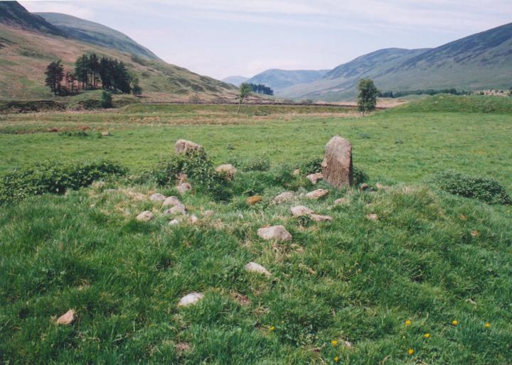
This circle is of the same type as its close neighbour Clach na Tiompan, but is in a better state of preservation (although still quite ruinous). Two stones remain standing, and a further two stoneholes have been identified. The stones protrude from cairn material, which spreads to a diameter of approximately 5.0m. The circle itself is nothing much to look at, but its location, between the steep sides of Glen Almond, is stunning.
remaining 2 stones – approximately 1.0m tall
cairn material approximately 5.0m in diameter


Alternative names for River Almond
Auchnafree; Clach na Tiompan; Glenshervie Burn
Where is River Almond?
River Almond is in the parish of Monzievaird and Strowan and the county of Perthshire.
Grid reference: NN 8259 3299
Lat / long: 56.47365005, -3.907700103

Directions to River Almond
Enter a starting point
Get directions
Weather at River Almond
6°C
max 6°C / min 5°C
max 6°C / min 5°C
7km/h NW
1026mb
71%
20%
04:57 19:31
1026mb
71%
20%
04:57 19:31
Few clouds
Weather observed at Perth and Kinross at 19:58
References (websites)
Ancient sites near River Almond
Castles near River Almond
Pictish stones near River Almond

Pictish sites near River Almond

Accommodation near River Almond
Comrie Croft SYHA Hostel
10.2km away
Knock Castle Hotel & Spa
11.0km away
Crieff Hydro self-catering cottages and chalets
11.1km away
Crieff Hydro Hotel and Leisure Resort
11.3km away
Murraypark Hotel
11.6km away
Galvelbeg House
11.9km away
James Cottage Guest House
12.1km away
Merlindale
12.7km away
The Kenmore Hotel
13.6km away
The Rowans
14.2km away
Accommodation search
Cafés, restaurants & bars near River Almond
Famous Grouse Experience
9.8km away
Knock Castle Hotel & Spa
11.0km away
Crieff Hydro Hotel and Leisure Resort
11.3km away
Torlum Café, Auchingarrich
13.9km away
Drummond Hotel
15.7km away
House of Menzies
16.4km away
The Watermill
16.4km away
Habitat Café
16.4km away
Aberfeldy Weem Hotel
16.9km away
Atholl Arms Hotel, Dunkeld
22.3km away


