Kinnell
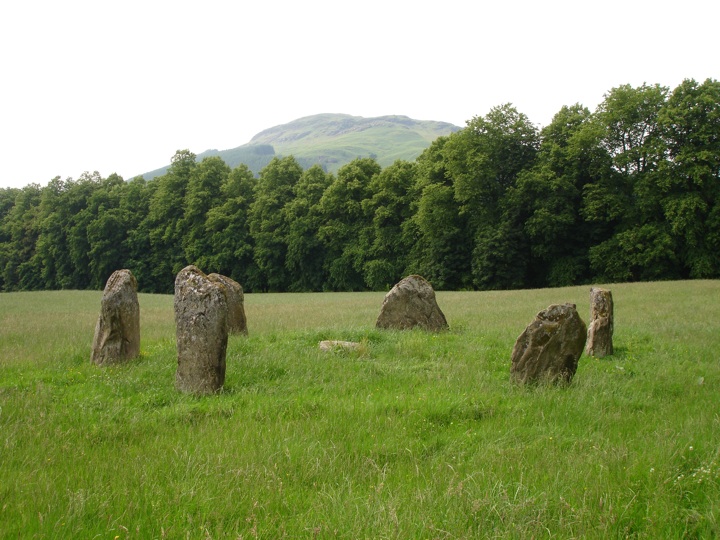
Kinnell stone circle stands just beyond the Falls of Dochart within the policies of Kinnell House, and close to the confluence of the River Dochart and River Lochay where they flow into Loch Tay.
The circle, around 10m in diameter, consists of six large stones between 1.4m and 1.9m in height. The most northerly stone is decorated with three cupmarks.


Alternative names for Kinnell
Achmore; Kinnell; Kinnell House; Kinnell Park
Where is Kinnell?
Kinnell is in the parish of Killin and the county of Perthshire.
Grid reference: NN 5770 3280
Lat / long: 56.46591697, -4.309954407
OS Map for Kinnell
Directions to Kinnell
Enter a starting point
Get directions
Weather at Kinnell
4°C
max 4°C / min 4°C
max 4°C / min 4°C
2km/h E
1006mb
87%
34%
04:44 19:45
1006mb
87%
34%
04:44 19:45
Scattered clouds
Weather observed at Comrie at 22:07
References (websites)
Ancient sites near Kinnell
Castles near Kinnell
Pictish stones near Kinnell

Pictish sites near Kinnell


Accommodation near Kinnell
The Courie Inn
0.6km away
Braveheart Backpackers
0.6km away
Killin Hotel
0.7km away
The Bridge Of Lochay Hotel
1.6km away
Clachan Cottage Hotel
9.2km away
Ardeonaig Hotel and Restaurant
9.4km away
Balquhidder Braes Log Cabins
11.8km away
Ben Lawers Hotel
12.1km away
Mhor 84 Motel
12.6km away
Drummond Hotel
14.4km away
Accommodation search
Cafés, restaurants & bars near Kinnell
The Courie Inn
0.6km away
Mhor 84 Motel
12.6km away
Glenlyon Tearoom
14.3km away
Drummond Hotel
14.4km away
Inn At Strathyre
15.9km away
Monachyle Mhor Hotel
16.6km away
The Rod & Reel
20.6km away
Best Western The Crianlarich Hotel
20.6km away
Poppies Hotel and Restaurant
24.5km away
Torlum Café, Auchingarrich
24.6km away


