Ferntower
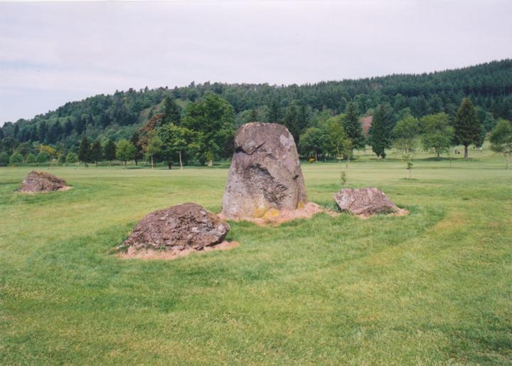
This stone circle is beautifully-located on Crieff’s Ferntower golf course, on a terrace overlooking Strathearn.
Three stones remain of an original four-poster circle measuring 5.5m in width and length, and form the W, S and E corners. The W stone measures 1.45m long by 1.25m wide and 0.7m high, the S stone is 1.6m by 1.5m by 0.6m high, and the E stone is 1.3m by 1.1m by 0.7m in height. The S stone has a cup-mark on it, close to a drill-hole.
At a distance of 7.5m to the ENE is an outlier, standing upright, measuring 1.8m tall by 1.7m wide and 0.8m thick. At its base lie two further stones of length 1.1m and 1.7m.
When Coles visited in 1911 all four stones were present in the circle. For some reason the N corner stone seems to have been removed, and may be one of the stones at the base of the outlier, as Coles only mentions one stone being at the outlier’s base.


Alternative names for Ferntower
Crieff golf course; Ferntower golf course
Where is Ferntower?
Ferntower is in the parish of Crieff and the county of Perthshire.
Grid reference: NN 8740 2262
Lat / long: 56.38234663, -3.823757562
OS Map for Ferntower

OS Explorer map OL47
Buy from Ordnance Survey
Directions to Ferntower
Enter a starting point
Weather at Ferntower
max 6°C / min 5°C
1025mb
73%
17%
04:47 19:39
Few clouds
Weather observed at Crieff at 21:16

References (books)

London and New Haven, 2000


