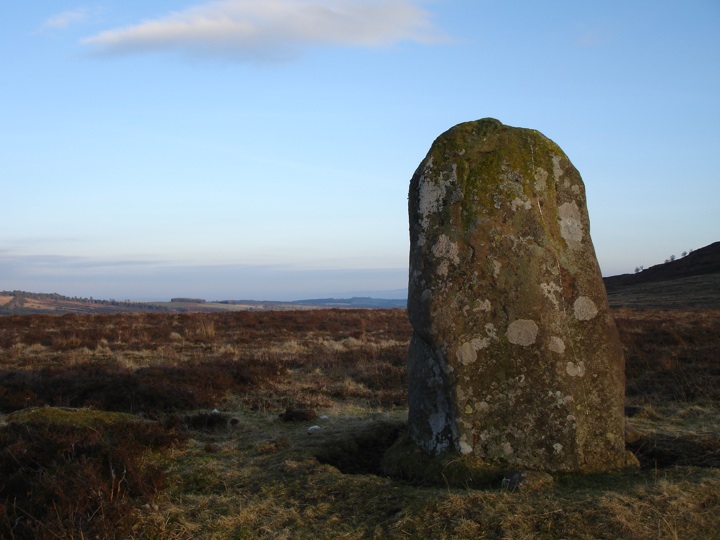
Dunruchan E
This stone is part of a wider complex of standing stones (comprising Dunruchan A, Dunruchan B, Dunruchan C, Dunruchan D and Dunruchan F). This stone would appear to be one half a typical Perthshire pair of standing stones. It measures 1.75m tall, and is rounded and chunky in appearance, in contrast to the slab-like shape of its near neighbour Dunruchan D.


Alternative names for Dunruchan E
Aodann Mhor; Cornoch; Craigneich; Shillinghill
Where is Dunruchan E?
Dunruchan E is in the parish of Muthill and the county of Perthshire.
Grid reference: NN 7898 1682
Lat / long: 56.32816238, -3.958669717
OS Map for Dunruchan E

Crieff, Comrie & Glen Artney (Strathearn & Auchterarder)
OS Explorer map OL47
Buy from Ordnance Survey
OS Explorer map OL47
Buy from Ordnance Survey
Directions to Dunruchan E
Enter a starting point
Get directions
Weather at Dunruchan E
2°C
max 2°C / min 1°C
max 2°C / min 1°C
1km/h NW
1006mb
95%
99%
04:41 19:45
1006mb
95%
99%
04:41 19:45
Overcast clouds
Weather observed at Comrie at 23:45
References (websites)
Ancient sites near Dunruchan E
Castles near Dunruchan E
Pictish stones near Dunruchan E

Pictish sites near Dunruchan E
Accommodation near Dunruchan E
Comrie Croft SYHA Hostel
6.3km away
James Cottage Guest House
8.3km away
Merlindale
8.8km away
Knock Castle Hotel & Spa
9.0km away
Galvelbeg House
9.4km away
Crieff Hydro Hotel and Leisure Resort
9.4km away
Crieff Hydro self-catering cottages and chalets
9.4km away
Murraypark Hotel
9.6km away
Cromlix House
10.7km away
The Four Seasons Hotel
12.1km away
Accommodation search
Cafés, restaurants & bars near Dunruchan E
Torlum Café, Auchingarrich
2.8km away
Knock Castle Hotel & Spa
9.0km away
Crieff Hydro Hotel and Leisure Resort
9.4km away
Famous Grouse Experience
9.5km away
Drummond Hotel
12.1km away
Sheriffmuir Inn
15.1km away
Roman Camp Hotel
18.2km away
The Crags Hotel
18.3km away
Dreadnought Hotel
18.5km away
Mhor Bread
18.5km away


