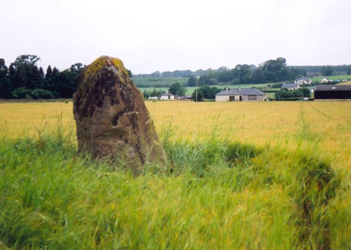
Dunning
This standing stone is 1.90m high by 1.00m wide and 0.80m thick. It is associated with a legend that it was the burial place of Doncha, Abbot of Dunkeld, who was killed in AD. 964 at the Battle of Duncrub.


Alternative names for Dunning
Battle Of Duncrub; Burial Place Of Doncha, Abbot Of Dunkeld; Leadketty Holdings
Where is Dunning?
Dunning is in the parish of Dunning and the county of Perthshire.
Grid reference: NO 0185 1469
Lat / long: 56.3137024, -3.587644361
OS Map for Dunning
Directions to Dunning
Enter a starting point
Get directions

Weather at Dunning
1°C
max 3°C / min 0°C
max 3°C / min 0°C
6km/h NNW
1022mb
81%
7%
04:44 19:39
1022mb
81%
7%
04:44 19:39
Clear sky
Weather observed at Auchterarder at 04:28

References (books)

References (websites)
Ancient sites near Dunning
Castles near Dunning
Pictish stones near Dunning
Pictish sites near Dunning
Accommodation near Dunning
Glendevon Hotel
7.9km away
Cairn Lodge Hotel
8.8km away
Duchally Country Estate
9.5km away
An Lochan Tormaukin
10.5km away
Gleneagles Hotel
10.7km away
Bronton Cottage B&B
12.0km away
Huntingtower Apartment
12.1km away
Symphony Lovat Hotel
12.3km away
At The Willows
12.3km away
The Rowans
12.4km away
Accommodation search
Cafés, restaurants & bars near Dunning
An Lochan Tormaukin
10.5km away
Huntingtower Hotel
12.4km away
Best Western Queens Hotel & Leisure Club
12.7km away
Breizh
13.5km away
Holiday Inn Express Perth
13.8km away
The Famous Bein Inn
14.2km away
Windlestrae Hotel and Leisure Club
15.3km away
The Green Hotel Golf & Leisure Resort
15.4km away
Crieff Hydro Hotel and Leisure Resort
17.1km away
Knock Castle Hotel & Spa
17.6km away


