Dundurn
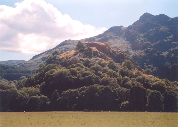
It’s easy to see why Dundurn was chosen as the site of a fort, as it rises steeply from the flat ground around it making it easy to defend. The slopes are littered with stones that are from the fort’s walls, which have now tumbled from their original position on the flat summit.
The views from the top are stunning, and show further it’s strategic importance, offering a sweeping vista of the wide flood plain of the River Earn below, and covering several major mountain passes.


Alternative names for Dundurn
Dùn Fhaoláin (Dun Fhaolain); St Fillan's Hill
Where is Dundurn?
Dundurn is in the parish of Comrie and the county of Perthshire.
Grid reference: NN 7080 2327
Lat / long: 56.38349022, -4.092730122
OS Map for Dundurn

Crieff, Comrie & Glen Artney (Strathearn & Auchterarder)
OS Explorer map OL47
Buy from Ordnance Survey
OS Explorer map OL47
Buy from Ordnance Survey
Directions to Dundurn
Enter a starting point
Get directions


Weather at Dundurn
5°C
max 5°C / min 5°C
max 5°C / min 5°C
7km/h SE
1005mb
92%
61%
04:43 19:44
1005mb
92%
61%
04:43 19:44
Broken clouds
Weather observed at Comrie at 19:02
References (websites)
Ancient sites near Dundurn
Castles near Dundurn
Pictish stones near Dundurn
Pictish sites near Dundurn

Accommodation near Dundurn
The Four Seasons Hotel
1.8km away
Drummond Hotel
1.8km away
Comrie Croft SYHA Hostel
9.2km away
Clachan Cottage Hotel
11.2km away
Ardeonaig Hotel and Restaurant
13.1km away
Balquhidder Braes Log Cabins
13.8km away
Mhor 84 Motel
14.7km away
Knock Castle Hotel & Spa
15.2km away
James Cottage Guest House
15.2km away
Crieff Hydro self-catering cottages and chalets
15.6km away
Accommodation search
Cafés, restaurants & bars near Dundurn
Drummond Hotel
1.8km away
Torlum Café, Auchingarrich
8.6km away
Mhor 84 Motel
14.7km away
Famous Grouse Experience
14.7km away
Knock Castle Hotel & Spa
15.2km away
Crieff Hydro Hotel and Leisure Resort
15.7km away
Inn At Strathyre
16.0km away
The Courie Inn
16.7km away
Poppies Hotel and Restaurant
17.2km away
The Crags Hotel
17.2km away


