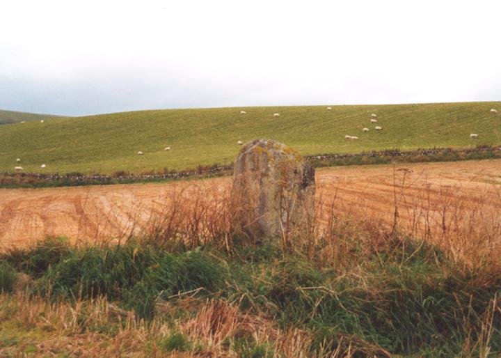
Drumend
This single standing stone sits on a slight mound towards the NW corner of a field off the A926. Standing 1.6m tall, it swells slightly around its middle, where it is wider than at it’s base or top. Around its base is piled field clearance, and it has obviously been scraped by farm machinery at some point. Although a largely unremarkable stone, it’s a nice site, with a good view to the south, over Strathmore, towards the King’s Seat and the distant Sidlaws.
stone – 1.6m tall


Alternative names for Drumend
Easter Rattray
Where is Drumend?
Drumend is in the parish of Rattray and the county of Perthshire.
Grid reference: NO 2018 4582
Lat / long: 56.59740303, -3.301423626
OS Map for Drumend
Directions to Drumend
Enter a starting point
Get directions

Weather at Drumend
11°C
max 13°C / min 8°C
max 13°C / min 8°C
10km/h E
1029mb
66%
100%
04:52 19:31
1029mb
66%
100%
04:52 19:31
Overcast clouds
Weather observed at Blairgowrie at 15:48
References (books)

References (websites)
Ancient sites near Drumend
Castles near Drumend
Pictish stones near Drumend


Pictish sites near Drumend

Accommodation near Drumend
Blairgowrie Holiday Park
2.1km away
Angus Hotel
2.2km away
The Royal Hotel, Blairgowrie
2.4km away
Altamount Country House Hotel
2.5km away
Alyth Hotel
5.2km away
Old Stables Bed and Breakfast / Self-Catering
5.3km away
Lands of Loyal Hotel
5.8km away
Meikleour Hotel
8.2km away
Bridge of Cally Hotel
8.4km away
Corriefodly Holiday Park
8.6km away
Accommodation search
Cafés, restaurants & bars near Drumend
Altamount Country House Hotel
2.5km away
Alyth Hotel
5.2km away
Lochside Lodge & Roundhouse Restaurant
11.9km away
Atholl Arms Hotel, Dunkeld
17.7km away
Murrayshall House Hotel
20.2km away
Premier Inn Dundee West
20.5km away
Premier Inn Dundee North
21.3km away
Holiday Inn Express Perth
22.4km away
Kinnettles Castle
22.5km away
Best Western Invercarse Hotel
23.0km away


