Crofthead Farm
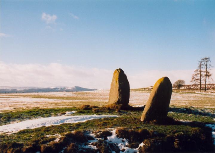
These two standing stones stand high on a ridge overlooking Strathearn with magnificent views south to the Ochils and beyond to the Lomonds of Fife, although they are themselves overlooked by the Braes of Fowlis stones on the next ridge.
The stones are approximately 1.65m and 1.85m tall and stand on pronounced mounds beside a small burn.
A line drawn from the centre of these stones to the New Fowlis cairn would have passed through the original position of the Thorn cup-marked boulder.


Alternative names for Crofthead Farm
The Thorn
Where is Crofthead Farm?
Crofthead Farm is in the parish of Fowlis Wester and the county of Perthshire.
Grid reference: NN 9203 2404
Lat / long: 56.39599306, -3.749869063
OS Map for Crofthead Farm

Crieff, Comrie & Glen Artney (Strathearn & Auchterarder)
OS Explorer map OL47
Buy from Ordnance Survey
OS Explorer map OL47
Buy from Ordnance Survey
Directions to Crofthead Farm
Enter a starting point
Get directions

Weather at Crofthead Farm
4°C
max 6°C / min 4°C
max 6°C / min 4°C
12km/h NNW
1005mb
64%
100%
04:42 19:42
1005mb
64%
100%
04:42 19:42
Overcast clouds
Weather observed at Crieff at 06:51
References (websites)
Ancient sites near Crofthead Farm
Castles near Crofthead Farm
Pictish stones near Crofthead Farm

Pictish sites near Crofthead Farm

Accommodation near Crofthead Farm
The Rowans
1.2km away
At The Willows
1.2km away
Murraypark Hotel
5.4km away
Galvelbeg House
5.6km away
Crieff Hydro Hotel and Leisure Resort
5.7km away
Crieff Hydro self-catering cottages and chalets
5.7km away
Merlindale
6.1km away
Knock Castle Hotel & Spa
6.2km away
James Cottage Guest House
6.7km away
Glendevon Hotel
11.6km away
Accommodation search
Cafés, restaurants & bars near Crofthead Farm
Crieff Hydro Hotel and Leisure Resort
5.7km away
Knock Castle Hotel & Spa
6.2km away
Famous Grouse Experience
6.5km away
Torlum Café, Auchingarrich
14.1km away
Huntingtower Hotel
15.4km away
Holiday Inn Express Perth
17.7km away
Best Western Queens Hotel & Leisure Club
19.2km away
Breizh
19.9km away
An Lochan Tormaukin
20.8km away
Atholl Arms Hotel, Dunkeld
21.4km away


