Craighall
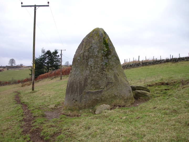
This massive standing stone, aligned NNE-SSW measures 2.5m in height by 1.7m wide at the base, and is decorated on its east side with numerous cupmarks. According to Historic Environment Scotland in 1986 there were 9 cupmarks, but in 1881 there were apparently 13. Four of the cupmarks are particularly well-defined and may represent the nearby Craighall stone circle.


Alternative names for Craighall
Glenballoch; Glenballoch Cottage
Where is Craighall?
Craighall is in the parish of Rattray and the county of Perthshire.
Grid reference: NO 1852 4826
Lat / long: 56.61868561, -3.328233365
OS Map for Craighall
Directions to Craighall
Enter a starting point
Get directions


Weather at Craighall
3°C
max 4°C / min 2°C
max 4°C / min 2°C
3km/h SW
1013mb
74%
27%
04:59 19:25
1013mb
74%
27%
04:59 19:25
Scattered clouds
Weather observed at Blairgowrie at 04:33
References (books)

References (websites)
Ancient sites near Craighall
Castles near Craighall
Pictish stones near Craighall

Pictish sites near Craighall
Accommodation near Craighall
Blairgowrie Holiday Park
2.2km away
The Royal Hotel, Blairgowrie
2.9km away
Angus Hotel
3.0km away
Altamount Country House Hotel
3.7km away
Bridge of Cally Hotel
5.6km away
Corriefodly Holiday Park
5.9km away
Alyth Hotel
6.0km away
Old Stables Bed and Breakfast / Self-Catering
6.0km away
Lands of Loyal Hotel
6.3km away
Meikleour Hotel
9.8km away
Accommodation search
Cafés, restaurants & bars near Craighall
Altamount Country House Hotel
3.7km away
Alyth Hotel
6.0km away
Lochside Lodge & Roundhouse Restaurant
11.6km away
Atholl Arms Hotel, Dunkeld
16.8km away
Murrayshall House Hotel
22.3km away
Premier Inn Dundee West
23.3km away
Holiday Inn Express Perth
23.9km away
Premier Inn Dundee North
24.1km away
Kinnettles Castle
24.1km away
Dalmunzie Castle
24.9km away


