Claverhouse's Stone
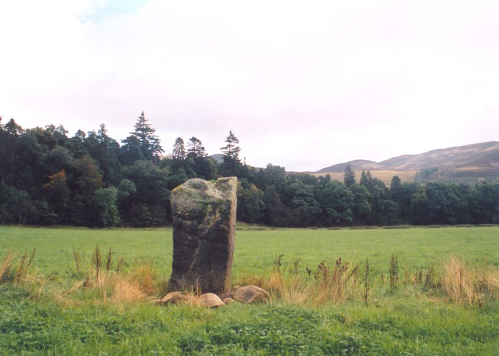
Claverhouse’s Stone – so named because John Graham of Claverhouse, Viscount of Dundee (the famed “Bonnie Dundee”) is believed to have died leaning against it after being injured in the nearby Battle of Killiecrankie in 1689 – stands approximately 1.6m tall, with packing stones and some field clearance visible at its base.


Alternative names for Claverhouse's Stone
Killiecrankie; Urrard House
Where is Claverhouse's Stone?
Claverhouse's Stone is in the parish of Moulin and the county of Perthshire.
Grid reference: NN 9082 6319
Lat / long: 56.7468585, -3.785776694
OS Map for Claverhouse's Stone

Directions to Claverhouse's Stone
Enter a starting point
Get directions

Weather at Claverhouse's Stone
11°C
max 12°C / min 10°C
max 12°C / min 10°C
11km/h NNW
1029mb
54%
74%
04:53 19:33
1029mb
54%
74%
04:53 19:33
Broken clouds
Weather observed at Pitlochry at 13:16

References (websites)
Ancient sites near Claverhouse's Stone
Castles near Claverhouse's Stone
Pictish stones near Claverhouse's Stone
Pictish sites near Claverhouse's Stone
Accommodation near Claverhouse's Stone
Killiecrankie House
0.5km away
River Tilt Park
3.9km away
Bridge of Tilt Hotel
4.0km away
Atholl Arms Hotel, Blair Atholl
4.4km away
Tigh na Cloich Hotel
5.1km away
Green Park Hotel
5.1km away
Moulin Hotel
5.2km away
Pine Trees Hotel Pitlochry
5.3km away
Craigatin House & Courtyard
5.4km away
Craigvrack Hotel
5.5km away
Accommodation search
Cafés, restaurants & bars near Claverhouse's Stone
Atholl Arms Hotel, Blair Atholl
4.4km away
Moulin Hotel
5.2km away
The Auld Smiddy Inn
5.6km away
Strathgarry Restaurant & Rooms
5.6km away
McKays
5.6km away
The Old Mill Inn
5.7km away
Kingfisher Bar
5.8km away
Scotland's Hotel & Spa
5.8km away
Victoria's Restaurant
6.0km away
Atholl Palace Hotel
6.4km away


