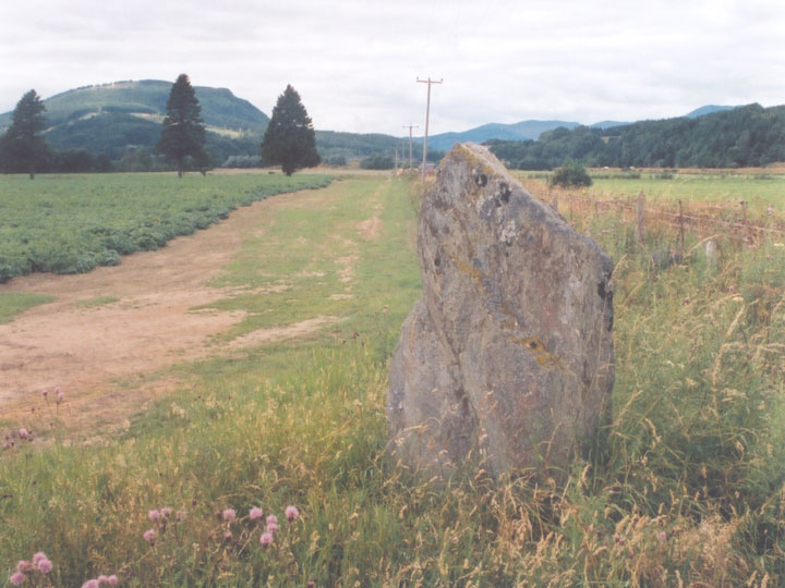
Clach Glas
The Clach Glas is not too far from the embankment for the railway on the flood plain of the Tay. It is around 1.7m tall by 1.0m wide, and is approximately 30cm thick, making it slab-like in appearance. It stands on a small but pronounced mound in which packing material is visible, and there was said to have once been more stones lying on the ground to the south and east, although these are no longer there. In the centre of the south face of the stone are two cup marks.


Alternative names for Clach Glas
Grey Stone; Westhaugh Of Tulliemet
Where is Clach Glas?
Clach Glas is in the parish of Logierait and the county of Perthshire.
Grid reference: NN 9853 5112
Lat / long: 56.64082614, -3.655181509
OS Map for Clach Glas

Directions to Clach Glas
Enter a starting point
Get directions


Weather at Clach Glas
8°C
max 10°C / min 7°C
max 10°C / min 7°C
13km/h ENE
1003mb
68%
100%
04:41 19:43
1003mb
68%
100%
04:41 19:43
Overcast clouds
Weather observed at Milton of Edradour at 15:42
References (books)

References (websites)
Ancient sites near Clach Glas
Castles near Clach Glas
Pictish stones near Clach Glas


Pictish sites near Clach Glas
Accommodation near Clach Glas
Cuil-an-Daraich Guest House
2.1km away
Dalshian Guest House
6.2km away
Atholl Palace Hotel
7.8km away
Acarsaid Hotel
8.0km away
Rosemount Hotel
8.1km away
Beinn Bhracaigh
8.2km away
Knockendarroch House Hotel
8.2km away
Carra Beag Guest House
8.3km away
Scotland's Hotel & Spa
8.4km away
Fisher's Hotel
8.5km away
Accommodation search
Cafés, restaurants & bars near Clach Glas
Atholl Palace Hotel
7.8km away
Victoria's Restaurant
8.3km away
Scotland's Hotel & Spa
8.4km away
Kingfisher Bar
8.4km away
The Old Mill Inn
8.5km away
McKays
8.6km away
Strathgarry Restaurant & Rooms
8.6km away
The Auld Smiddy Inn
8.7km away
Moulin Hotel
9.2km away
Atholl Arms Hotel, Dunkeld
9.4km away


