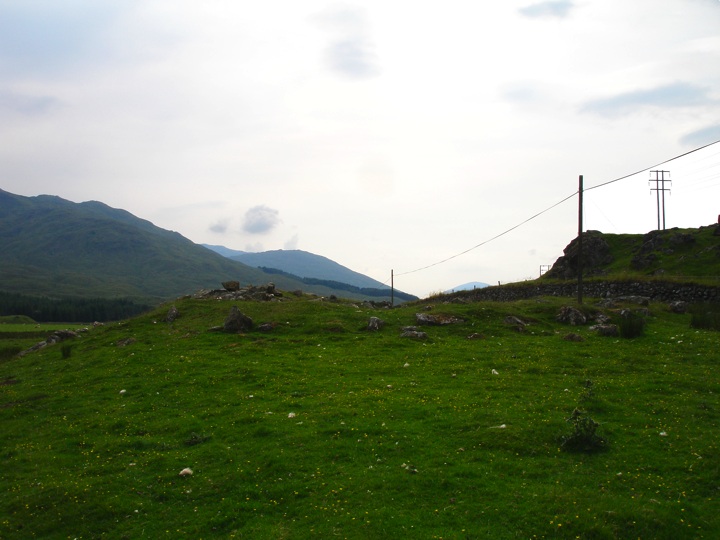
Caisteal Cona Bhacain
Caisteal Cona Bhacain is an interesting site in that it is of a type unique to the Glen Lyon area. Sometimes described as a homestead, sometimes described as a fort, what is clear from the remains is that this structure was certainly defensive in nature. Massive boulders make up a circular wall between 3m and 4m thick, with an entrance at the eastern end.
The plan of the structure is oval in shape, measuring approximately 27m east to west by 20m north to south.


Alternative names for Caisteal Cona Bhacain
Caisteal a' Chonbhacain; Cashlie
Where is Caisteal Cona Bhacain?
Caisteal Cona Bhacain is in the parish of Fortingall and the county of Perthshire.
Grid reference: NN 4828 4168
Lat / long: 56.54194853, -4.469142781
OS Map for Caisteal Cona Bhacain
Directions to Caisteal Cona Bhacain
Enter a starting point
Get directions


Weather at Caisteal Cona Bhacain
4°C
max 4°C / min 4°C
max 4°C / min 4°C
24km/h WNW
1013mb
90%
86%
04:59 19:33
1013mb
90%
86%
04:59 19:33
Overcast clouds
Weather observed at Comrie at 00:26
References (websites)
Ancient sites near Caisteal Cona Bhacain
Castles near Caisteal Cona Bhacain
Pictish stones near Caisteal Cona Bhacain

Pictish sites near Caisteal Cona Bhacain

Accommodation near Caisteal Cona Bhacain
The Bridge Of Lochay Hotel
11.4km away
Killin Hotel
12.2km away
Braveheart Backpackers
12.3km away
The Courie Inn
12.5km away
Inverardran House
17.1km away
Bridge of Orchy Hotel
18.5km away
Tyndrum Lodge Hotel
18.9km away
Best Western The Crianlarich Hotel
19.0km away
Crianlarich SYHA Hostel
19.0km away
Ardeonaig Hotel and Restaurant
19.4km away
Accommodation search
Cafés, restaurants & bars near Caisteal Cona Bhacain
Glenlyon Tearoom
11.3km away
The Courie Inn
12.5km away
Bridge of Orchy Hotel
18.5km away
The Green Welly Stop
18.9km away
Best Western The Crianlarich Hotel
19.0km away
The Rod & Reel
19.0km away
Monachyle Mhor Hotel
21.9km away
Mhor 84 Motel
22.8km away
Macdonald Loch Rannoch
24.2km away
Dunalastair Hotel
24.7km away


