Airlie
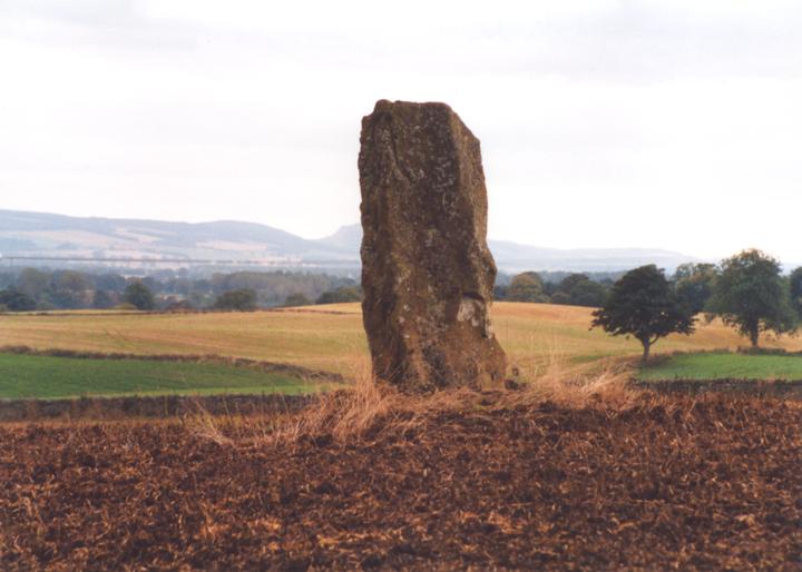
This slab-like standing stone is in a prominent position on the crest of a knoll overlooking Strathmore, and measures 2.0m tall. In the 18th century human remains were found at its base, supposedly the victims of a battle here.


Alternative names for Airlie
Baitland; Cairnwell; Carlinwell
Where is Airlie?
Airlie is in the parish of Airlie and the county of Angus.
Grid reference: NO 3208 5025
Lat / long: 56.63880535, -3.108797223
OS Map for Airlie
Directions to Airlie
Enter a starting point
Get directions

Weather at Airlie
6°C
max 7°C / min 6°C
max 7°C / min 6°C
2km/h E
1005mb
75%
64%
04:39 19:41
1005mb
75%
64%
04:39 19:41
Broken clouds
Weather observed at Kirkton of Airlie at 18:53

References (websites)
Ancient sites near Airlie
Castles near Airlie
Pictish stones near Airlie
Pictish sites near Airlie

Accommodation near Airlie
Castleton House Hotel
3.7km away
Lochside Lodge & Roundhouse Restaurant
5.8km away
Lands of Loyal Hotel
7.3km away
Old Stables Bed and Breakfast / Self-Catering
7.6km away
Alyth Hotel
7.6km away
Crawford Cottages
8.0km away
Kinnettles Castle
11.1km away
The Hideaway Experience
13.2km away
Royal Hotel, Forfar
13.5km away
Chapelbank Hotel
13.7km away
Accommodation search
Cafés, restaurants & bars near Airlie
Lochside Lodge & Roundhouse Restaurant
5.8km away
Alyth Hotel
7.6km away
Kinnettles Castle
11.1km away
Altamount Country House Hotel
15.1km away
Premier Inn Dundee North
18.3km away
Premier Inn Dundee West
19.0km away
Best Western Invercarse Hotel
20.9km away
Duke's Corner
21.4km away
Number Twenty Five
21.7km away
Papa Joe's Dundee
21.7km away


