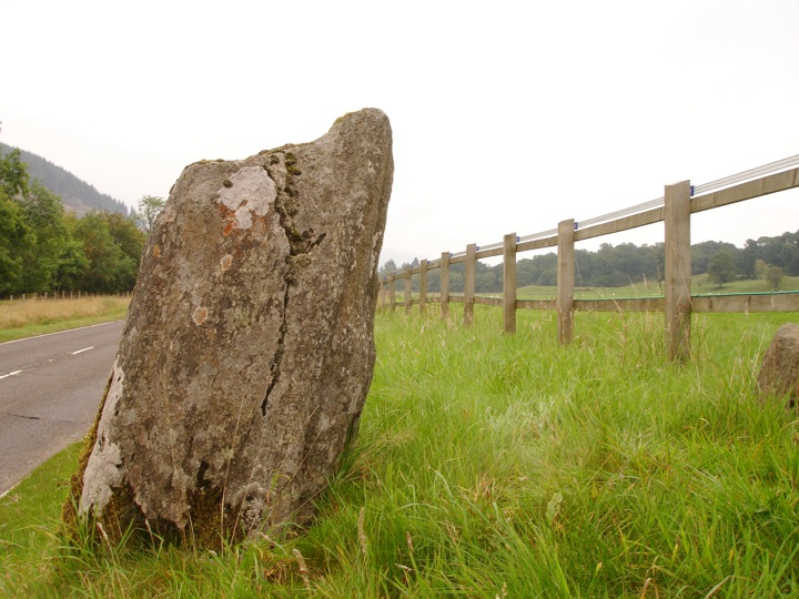
Acharn
This single stone measures 1.2m high by 0.7m wide and 0.3m thick (at the base) and stands on a bank beside the road.


Where is Acharn?
Acharn is in the parish of Killin and the county of Perthshire.
Grid reference: NN 5614 3160
Lat / long: 56.45465813, -4.335241442
OS Map for Acharn
Directions to Acharn
Enter a starting point
Get directions


Weather at Acharn
2°C
max 2°C / min 2°C
max 2°C / min 2°C
7km/h WSW
1021mb
86%
100%
05:01 19:30
1021mb
86%
100%
05:01 19:30
Overcast clouds
Weather observed at Comrie at 04:00
References (books)
References (websites)
Ancient sites near Acharn
Castles near Acharn
Pictish stones near Acharn

Pictish sites near Acharn
Accommodation near Acharn
The Courie Inn
1.6km away
Braveheart Backpackers
2.1km away
Killin Hotel
2.1km away
The Bridge Of Lochay Hotel
2.7km away
Clachan Cottage Hotel
8.5km away
Balquhidder Braes Log Cabins
10.7km away
Mhor 84 Motel
11.3km away
Ardeonaig Hotel and Restaurant
11.3km away
Ben Lawers Hotel
14.1km away
Airlie House Bed and Breakfast
14.4km away
Accommodation search
Cafés, restaurants & bars near Acharn
The Courie Inn
1.6km away
Mhor 84 Motel
11.3km away
Inn At Strathyre
14.6km away
Monachyle Mhor Hotel
14.7km away
Drummond Hotel
15.1km away
Glenlyon Tearoom
15.6km away
The Rod & Reel
18.7km away
Best Western The Crianlarich Hotel
18.7km away
The Green Welly Stop
23.2km away
Poppies Hotel and Restaurant
23.6km away


